
Flood disaster in Queensland and New South Wales after a year’s worth of rain, Australia
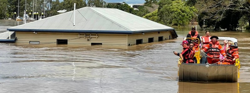
Image credit: QFES
The Australian Bureau of Meteorology (BOM) has issued numerous major flood warnings across southeast Queensland and northern New South Wales (NSW) with a severe weather warning remaining current for several parts of the region. Multiple major flood warnings remain current for north-eastern NSW including the Tweed, Richmond, Wilsons, Clarence, Brunswick rivers and Marshall Creek. Authorities are describing the situation as unprecedented and warning the worst is yet to come!
- At least 8 people have been killed and three remain missing in Queensland after a year's worth of rain fell on parts of the southeast.
- Record river flooding has been reported, in parts of the region 2 m (6.5 feet) above record.
- 58 000 homes have been flooded in Brisbane alone
- Tens of thousands of customers are without power
- Public transport is disrupted and many schools closed
- Residents are asked to conserve water
While the intense rainfall experienced across south-east Queensland, particularly around Brisbane, was not related to a tropical cyclone, it was of similar intensity in some areas, BOM meteorologists said.1
Locally intense rainfall remains likely around the Gold Coast and northern New South Wales today.
The intense rainfall is expected to move south of the Queensland-New South Wales border during Monday afternoon.
With many catchments saturated, dangerous and life-threatening flash flooding and landslides continue to occur, and emergency services are advising the community to monitor the situation closely.
Flooding impacts are being seen across southeast Queensland and into northern New South Wales.
Major flood warnings are current for several rivers across the region including the Upper and Lower Brisbane rivers, Logan and Albert rivers, Bremer River and Warrill Creek, the Mary River, the Noosa River, and Condamine and Balonne rivers.
Flooding of the Brisbane River is impacting inner-city areas. Peak water levels are expected to exceed moderate to major flood levels at high tide on Monday and Tuesday and will not fall below minor until later this week.
The flood warning for the Brisbane River continues to consider the releases from Wivenhoe Dam, being managed by SEQ Water.
Damaging to locally destructive wind gusts are possible at the Gold Coast and nearby hinterland areas this morning.
Flooding is impacting populated communities including Gympie, Maryborough, Sunshine Coast, Ipswich and Brisbane, and Lismore and Grafton.
Parts of southeast Queensland may see additional localized flash flooding in the coming week with indications that severe thunderstorms with large hail, damaging winds and heavy rainfall are possible around southeast Queensland from Wednesday and into the weekend.
Communities should be prepared for flood impacts and are encouraged to keep up to date with the latest forecasts and warnings on the Bureau's website and BOM Weather app, and to follow the advice of emergency services.
Multiple major flood warnings remain current for north-eastern New South Wales including the Tweed, Richmond, Wilsons, Clarence, Brunswick rivers and Marshall Creek.2
Wilsons River at Lismore is currently higher than the February 1954 and 1974 levels and is continuing to increase.
Dangerous and life-threatening flash flooding will continue for parts of the Northern Rivers and Mid North Coast throughout Monday.
Rain will continue today and gradually ease in the far north later this afternoon and later this evening for parts of the Mid North Coast as the low moves a little further south. Further rain and thunderstorms are possible on Thursday and Friday across the northern NSW coast.
Along the southern half of the NSW coast, riverine flooding may also develop with heavy rain forecast on Wednesday as a low moves towards the central NSW coast. This system may also bring damaging winds and waves.
A hazardous surf warning for the Byron Coast, Coffs Coast and Macquarie Coast is current and is likely to extend to the south of the state by Wednesday.
With many catchments saturated, flash flooding and landslides are occurring, and emergency services are advising the community to stay off the roads and monitor the situation closely.
Communities should be prepared for flood impacts and are encouraged to keep up to date with the latest forecasts and warnings on the Bureau's website and BOM Weather app, and to follow the advice of emergency services.
References:
1 Major flooding continues in Queensland – February 28, 2022 – BOM
2 Major flooding continues in northern New South Wales – February 28, 2022 – BOM
I'm a dedicated researcher, journalist, and editor at The Watchers. With over 20 years of experience in the media industry, I specialize in hard science news, focusing on extreme weather, seismic and volcanic activity, space weather, and astronomy, including near-Earth objects and planetary defense strategies. You can reach me at teo /at/ watchers.news.
Commenting rules and guidelines
We value the thoughts and opinions of our readers and welcome healthy discussions on our website. In order to maintain a respectful and positive community, we ask that all commenters follow these rules.