
Ex-Tropical Cyclone “Seth” producing high tides and dangerous surf in parts of Queensland and NSW, Australia
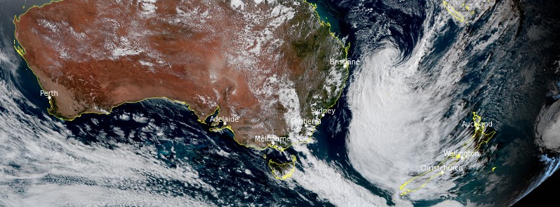
Featured image: Ex-Tropical Cyclone "Seth" at 06:10 UTC on January 2, 2021. Credit: JMA/Himawari-8, RAMMB/CIRA, TW
Tropical Cyclone "Seth" formed in the Coral Sea NE of Mackay, Queensland on December 31, 2021, as the 4th named storm of the 2021/22 Australian region cyclone season. While Seth is not expected to directly affect the coastline over the weekend, it will direct large waves toward the coast, and produce strong winds and heavy rain.
Seth remained a category 1 cyclone well offshore the coast of Queensland on January 1 before weakening to a tropical low.
However, dangerous surf and abnormally high tides are likely about exposed beaches in southeast Queensland and northeast New South Wales, and Severe Weather Warnings and Dangerous Surf Warnings are in effect, the Australian Bureau of Meteorology (BOM) warned.
Due to the extreme weather, 14 beaches were forced to shut along the Sunshine Coast and Gympie regions.
Meanwhile, flash flooding caused several road closures across southeast Queensland with at least five people left stranded by floodwaters.1
Emergency services including a rescue 500 chopper were called to McNamara Rd at Rocksberg, east of Caboolture on Saturday after multiple cars became stuck.
Queensland Fire and Emergency Service said the motorists had become stranded near where the road crossed the Caboolture River.
At 05:00 UTC on January 2, Seth was a tropical low moving SW at 15 km/h (9 mph) with sustained winds near the center of 75 km/h (45 mph) and wind gusts to 110 km/h (68 mph).2
Its center was located about 590 km (365 miles) ESE of Hervey Bay and 560 km (347 miles) E of Brisbane.
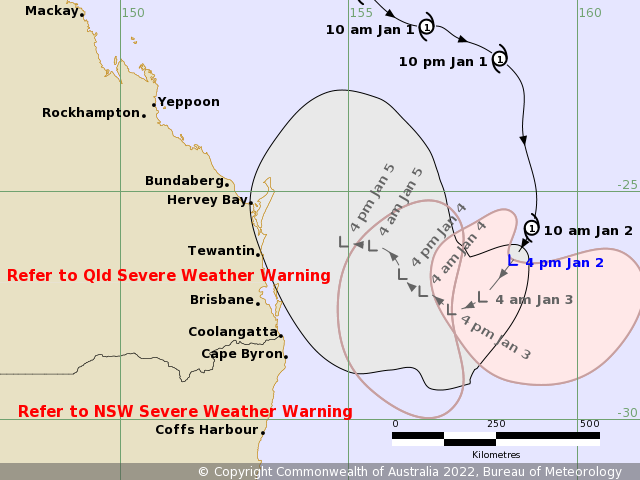
"Ex-Tropical Cyclone Seth has transitioned to a sub-tropical system," BOM said.
"Although it is no longer classified as a tropical cyclone, the system will continue to produce gale force winds as it moves south to south-westward during the remainder of Sunday.
On Monday, January 3, Seth is expected to take a more westward motion and may approach the northern New South Wales or southern Queensland coasts by mid-week, however, the exact path the system takes is uncertain at this time.
While this system is not expected to directly impact the coastline in the next 48 hours, it will cause dangerous surf and abnormally high tides about the southeast Queensland and northeast New South Wales coastlines.
If the remnants of the system approach the southeast Queensland coast during Tuesday and Wednesday, strong and gusty winds, possibly damaging may develop ahead of the system.
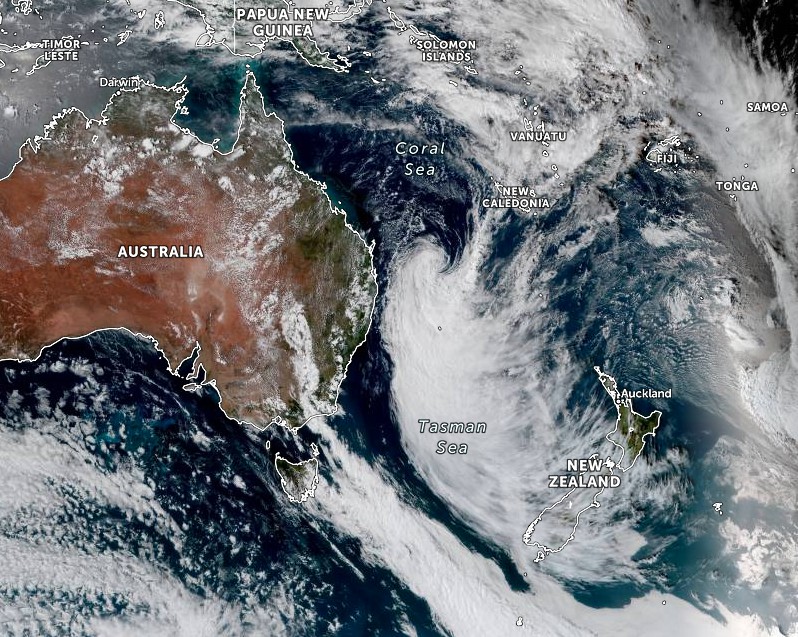
Ex-Tropical Cyclone "Seth" at 05:30 UTC on January 2, 2022. Credit: JMA/Himawari-8, Zoom.Earth, TW
References:
1 Powerful tropical cyclone bears down on Australia's east coast bringing destructive winds and major flooding – forcing dozens of beaches to close – DailyMail
2 TROPICAL CYCLONE FORECAST TRACK MAP for Ex-Tropical Cyclone Seth Issued at 4:09 pm AEST Sunday 2 January 2022
I'm a dedicated researcher, journalist, and editor at The Watchers. With over 20 years of experience in the media industry, I specialize in hard science news, focusing on extreme weather, seismic and volcanic activity, space weather, and astronomy, including near-Earth objects and planetary defense strategies. You can reach me at teo /at/ watchers.news.
Commenting rules and guidelines
We value the thoughts and opinions of our readers and welcome healthy discussions on our website. In order to maintain a respectful and positive community, we ask that all commenters follow these rules.