
Eruption of underwater volcano near Mayotte continues, may badly affect Lake Dziani on Petite Terre
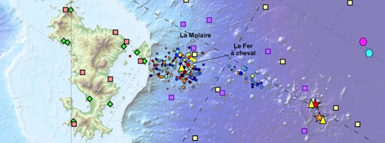
Image credit: REVOSIMA
Eruption at a developing submarine volcano east of Mayotte continues and may contaminate Petite Terre's Lake Dziani. The underwater volcano is the reason behind the seismo-volcanic crisis affecting the small island in the Indian Ocean since May 2018. The crisis started with earthquake swarm that continued for months causing anxiety among locals until May 2019 when a new developing volcano was confirmed.
An underwater eruption is officially underway as of July 31, 50 – 60 km (31 – 37 miles) east of Mayotte.
The seismic activity is centered at 5 to 15 km (3 to 9 miles) from Petite Terre at depths of 25 to 47 km (16 to 29 miles). It remains stationary with a high number of quakes.
544 were recorded so far from October 16, 2019, to October 31. The average seismic activity is 38 per day, with the recording of a clear recrudescence of seismic energy released.
#Mayotte : bulletin #Revosima n°7 sur l’activité sismo-volcanique.
Bilan du 16 au 31 octobre :
202 séismes localisés
une moyenne de 13 #séismes par jour
dont 1 par jour de magnitude supérieure ou égale à 3
magnitude maximum ressentie 4,2
https://t.co/Rk3VspsdLk pic.twitter.com/5LUSFGPGpk— BRGM (@BRGM_fr) November 12, 2019
#Mayotte : retrouvez sur notre compte Instagram de nouvelles images issues des campagnes d’observation du #volcan !
https://t.co/0DPmjDdz7U
https://t.co/lSKpu5YSCX
Et encore plus de photos dans notre story dédiée.#MAYOBS pic.twitter.com/2uxtBtNfw7— BRGM (@BRGM_fr) July 31, 2019
Since the start of the crisis, GPS stations recorded a displacement towards the east part of the island of 190 to 210 mm (7 to 8 inches), and subsidence of 80 to 160 mm (3 to 6 inches), more to the east than to the west.
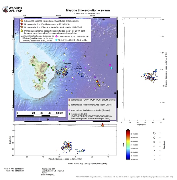
Image credit: REVOSIMA
The volcano is located 50 km (31 miles) east of the Petite-Terre island at a depth of 3 500 m (11 482 feet), BGRM, the France-based geological agency serving the territory said.
The current size of the volcano is estimated at 800 m (2 624 feet), with a base of 4 to 5 km (2.5 – 3.1 miles) in diameter.
The gas emanations reported along the Petite-Terre coastline are a common sign encountered in this type of volcanic activity and are the subject of specific studies.
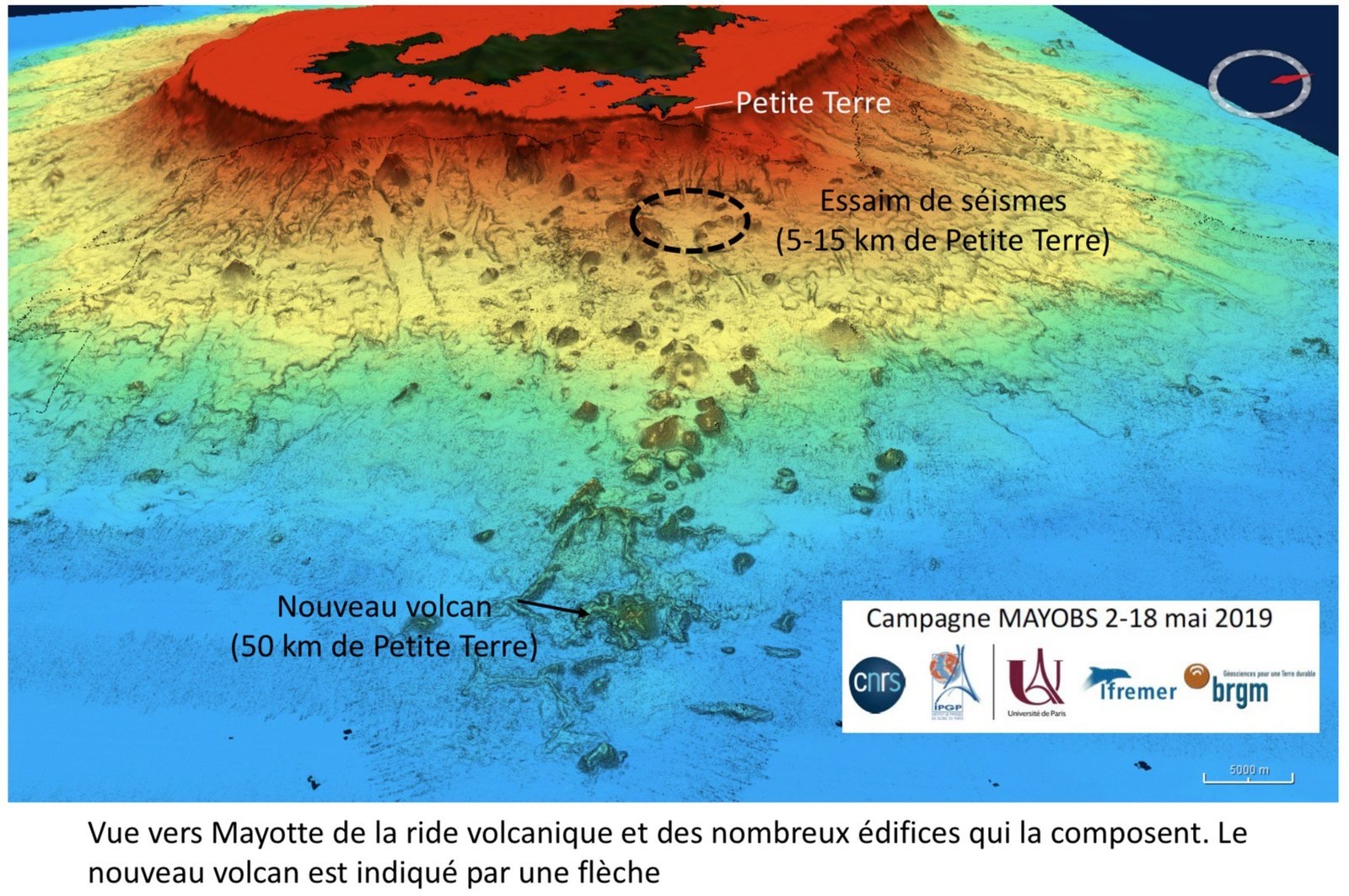
Image credit: MAYOBS
The new volcano might affect the maar Lake Dziani on Petite Terre as the impact due to subsidence may cause cracks and infiltration of waters of the lagoon, altering its unique composition. This might lead to the lake eventually vanishing.
The lake is known for its green, almost fluorescent waters because of Spirulina– a biomass of cyanobacteria.
The crisis began with a rare earthquake swarm on May 10, 2018. The tremors were initially believed to be the result of a seismic hot spot as well as the island’s position along the East African Rift.
The seismic activity remained abnormal and persisted for months, leaving locals in fear. There were no serious injuries or fatalities, but in June 2018, locals reported minor damage to buildings, including a school in Dembeni.
In January 2019, the Mayotte seismo-volcanic crisis intensified as a large number of dead fish emerged at various sites off of the barrier reef, and the earthquake swarm was believed to be one of the possible causes.
Authorities then launched several major observation missions by late February 2019, with results expected within 6 months. The missions are coordinated by CNRS with the support of BRGM, IPGP, IGN, Ifremer and the Environment Ministry of France.
Attempts to understand the reason behind the intense volcano-seismic crisis affecting Mayotte finally resulted in a solid answer around May 2019, when the submarine volcano was discovered.
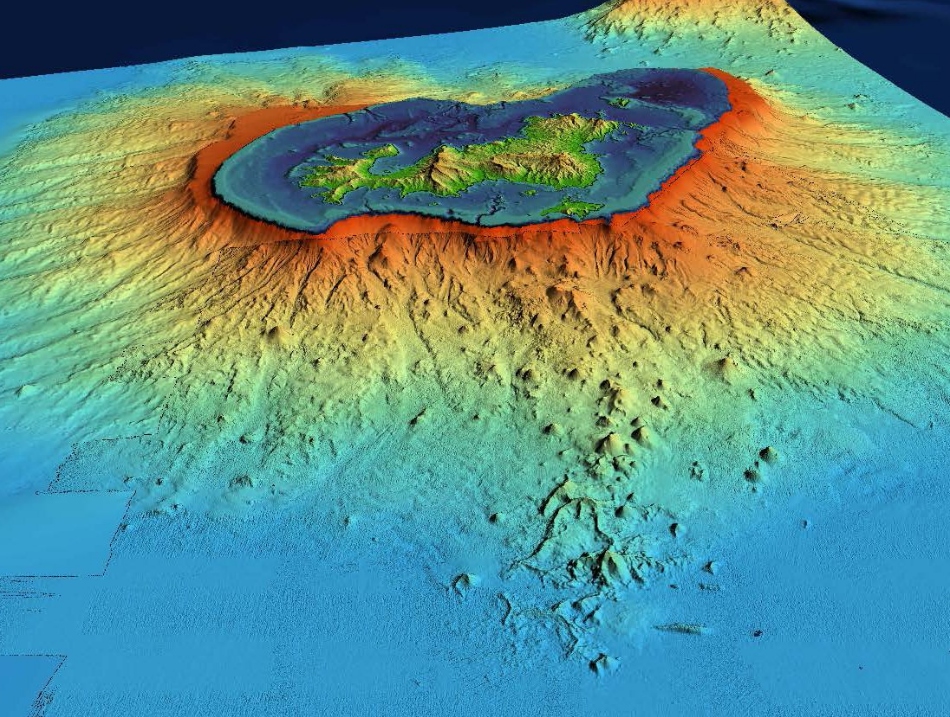
Image credit: BRGM
Geological background
Mayotte Island in the Mozambique Channel between the northern tip of Madagascar and the eastern coast of Africa consists of two volcanoes with diverse geochemistry that were active from the Pliocene to the Holocene. Lavas on the NE were active from about 4.7 to 1.4 million years and on the south from about 7.7 to 2.7 million years.
Mafic activity resumed on the north from about 2.9 to 1.2 million years and on the south from about 2 to 1.5 million years. Morphologically youthful-looking maars are present on Mayotte Island, and Zinke et al. (2003) found several pumice layers of Holocene age in gravity cores on the barrier reef-lagoon complex at Mayotte. (GVP)
Commenting rules and guidelines
We value the thoughts and opinions of our readers and welcome healthy discussions on our website. In order to maintain a respectful and positive community, we ask that all commenters follow these rules.