
Tropical Cyclone Chido hits Agalega as the strongest in over 50 years, heads toward Mayotte and Mozambique
Tropical Cyclone Chido rapidly intensified before making landfall over the Agalega on Thursday, December 12, 2024, as the strongest cyclone to hit the island since 1983. The cyclone is now heading toward Madagascar, Mayotte, and Mozambique.

Satellite image of Tropical Cyclone Chido at 12:15 UTC on December 12, 2024. Credit: EUMETSAT/Meteosat, RAMMB/CIRA, The Watchers
- Tropical Cyclone Chido underwent rapid intensification soon after formation, with wind speeds surging from 111 km/h (69 mph) to 222 km/h (138 mph) in 24 hours to 21:00 UTC on December 11.
- The system made landfall over the island of Agalega, Mauritius as the strongest cyclone to hit the island since 1983.
- Chido is expected to brush past northern Madagascar on Friday, December 13, and approach Mayotte before likely making landfall near Nacala, Mozambique, on Sunday, December 15.
Tropical Cyclone Chido formed in the Southwest Indian Ocean Basin on Tuesday, December 10, as the third named storm of the 2024/25 Southwest Indian Ocean Cyclone season. Rapid intensification started soon after formation, with wind speeds increasing from 111 km/h (69 mph) to 222 km/h (138 mph) in 24 hours to 21:00 UTC on Wednesday, December 11.
The system was located near the Island of Agalega (population 330) at around 00:00 UTC on Thursday, making landfall on Agaléga North Island later on the same day as a category 4-equivalent intense tropical cyclone.
Chido became the strongest cyclone to hit the island since Cyclone Andry in 1983, which claimed one life, left around 349 stranded, and destroyed nearly all structures on the island.

Enhanced Infrared (EIR) imagery acquired at 18:00 UTC on Wednesday showed a compact 11 km (7 miles) wide eye surrounded by stronger convection.

Chido will brush past the northern tip of Madagascar at around 18:00 UTC on Friday and is forecast to move close to or possibly directly over Mayotte in the northern Mozambique Channel on Saturday, December 14.
It is expected to make landfall along the northeastern coast of Mozambique, likely just north of Nacala, on Sunday, December 15.
Advanced intensity analysis tools indicate that the system peaked at around 16:00 UTC on Wednesday, when the raw Advanced Dvorak Technique (ADT) values exceeded T6.2, with the eye reaching its warmest temperatures. The cyclone is expected to weaken as it approaches Madagascar due to cooler sea surface temperatures, with a possible eyewall replacement cycle temporarily weakening the storm.
Despite weakening, the system is expected to remain a strong tropical cyclone near Mayotte. The system is forecast to have maximum sustained winds of around 130 – 150 km/h (80 – 95 mph) at landfall and is expected to rapidly weaken and dissipate by December 16.
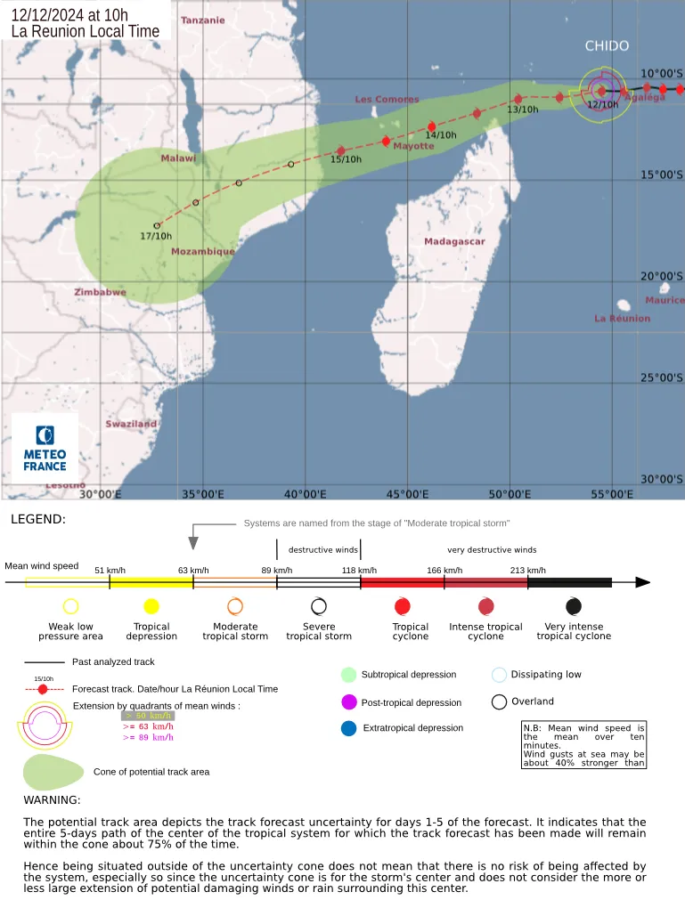
At 12:42 UTC on December 12, the center of Intense Tropical Cyclone Chido was located about 920 km (570 miles) ENE of Mayotte, according to Meteo France.
The cyclone had maximum (10-minute) wind speed of 215 km/h (135 mph), gusting to 295 km/h (185 mph), and minimum central pressure of 936 hPa. It was moving west at 22 km/h (14 mph).
In northern Madagascar (Antsiranana province), a deterioration in weather conditions is expected from Friday morning, accompanied by heavy rain, strong winds, even locally destructive, and dangerous seas, particularly in the north of the region. Conditions should improve on Saturday.
Concerning Mayotte, the prefect placed the department on cyclone pre-alert yesterday. The system is expected to pass close to the island and a deterioration in weather conditions is expected from Saturday morning with strong winds, heavy rain and possible coastal flooding. The extent of the deterioration will depend a lot on the distance of the system’s passage.
For the Comoros, Chido is expected to pass in close proximity to the archipelago, causing a deterioration in weather conditions starting Saturday, with strong winds, heavy rainfall, and potential coastal flooding.
For Mozambique, it is still too early to target the precise region of impact of the system during the weekend, due to the uncertainty in the forecast and the small size of the system.
Residents of all affected regions are invited to follow official forecasts, through their national meteorological service.
References:
1 PROGNOSTIC REASONING FOR TROPICAL CYCLONE 04S (CHIDO) – JTWC – Issued at 21:00 UTC on December 11, 2023
2 Bulletin D’Information Cyclone Tropical Indense Chido – Meteo France – 12:42 UTC on December 12, 2024
3 MAURITIUS – Cyclone – USaid.gov – December 8, 1983

I am an Assistant Editor and Severe Weather & Science Journalist at The Watchers, specializing in real-time severe weather coverage, geophysical event reporting, and research-driven scientific analysis. You can reach me at rishav(at)watchers(.)news.
Commenting rules and guidelines
We value the thoughts and opinions of our readers and welcome healthy discussions on our website. In order to maintain a respectful and positive community, we ask that all commenters follow these rules.