
Parts of New York under State of Emergency as third lake-effect snowstorm brings heavy snowfall
New York Governor Kathy Hochul declared a State of Emergency for parts of Western New York, the Finger Lakes, Central New York, and the North Country regions, as heavy lake-effect snow is expected to bring up to 90 cm (3 feet) of accumulation in the third lake-effect snowstorm of the season.
Governor Kathy Hochul declared a State of Emergency for parts of the Western New York, Finger Lakes, Central New York and North Country regions on Wednesday, December 11, and urged communities to prepare for up to 90 cm (3 feet) of snow in the third lake-effect snowstorm of the season.
The order takes effect on Thursday, December 12 for Cattaraugus, Chautauqua, Erie, Franklin, Genesee, Hamilton, Herkimer, Jefferson, Lewis, Oswego, St. Lawrence, Wyoming and contiguous counties.
The New York State Department of Transportation (NYSDOT) has issued a tandem and empty tractor-trailer ban for NY Route 5 from NY 179 to I-190, US 219 from I-90 to I-86, NY Route 400 from I-90 to NY 16, and I-86 from US 219 to the Pennsylvania state line.
“Our first responders and emergency crews are on the ground, ready to deal with this storm. I urge New Yorkers to take precautions to stay safe. Monitor your local forecasts, avoid unnecessary travel, and sign up for emergency alerts,” said Governor Hochul.
Peak snowfall rates of 5 – 8 cm (2 – 3 inches) per hour are expected during the storm, with strong winds and gusts of 50 – 70 km/h (30 – 45 mph), possibly resulting in whiteout conditions. Strong wind gusts, heavy rain, and coastal flooding may cause hazardous travel conditions and power outages downstate.
Heavy lake-effect snow is expected to develop over the region through Thursday night into Friday morning, with significant blowing and drifting snow in lake-effect areas. The heaviest lake-effect snow is forecasted east of Lake Erie and Lake Ontario.
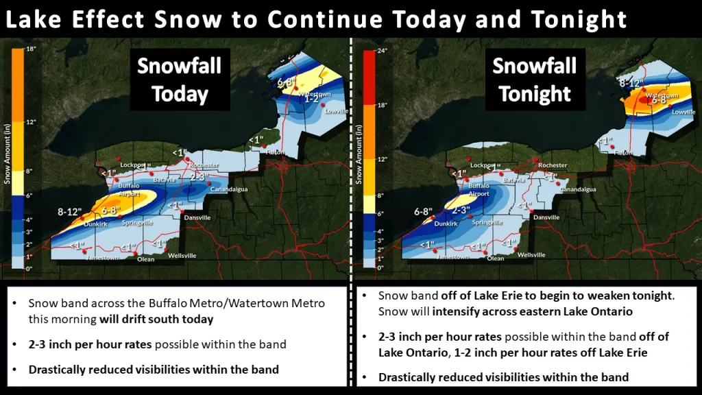
The snow band off Lake Erie is expected to weaken on Thursday night, while snow will intensify across eastern Lake Ontario. Snowfall rates of 5 – 78 cm (2 – 3 inches) per hour are possible within the snow band off Lake Ontario, while rates of 2.5 – 5 cm (1 – 2 inches) per hour are expected off Lake Erie.
Visibility will be significantly reduced within these snow bands, creating hazardous travel conditions. NYSDOT warned of rain and icy roads through Thursday crews in New York are working to address these conditions.
The snowstorm is caused by an influx of arctic air driven by a deep low-pressure system moving into eastern Canada. As an associated cold front exits New England, an arctic high-pressure system will dominate the northern Plains and expand across the eastern U.S. over the next two days.
Heavy rain in Maine will clear early today, followed by significantly colder temperatures and strong westerly winds.
Meanwhile, on the West Coast, a Pacific cyclone is bringing heavy precipitation to northern California and the Pacific Northwest. Coastal and lower elevations will experience rain, while higher elevations, including the Sierra Nevada, are forecast to receive moderate to heavy snow. This precipitation will ease temporarily tonight before another Pacific system arrives Friday, bringing further heavy rainfall to northern California and southwestern Oregon into Saturday, with a marginal risk of excessive rainfall.
The arctic high-pressure system will bring sub-zero temperatures to parts of the eastern U.S. by Saturday morning. As it shifts eastward, southerly winds will draw Gulf moisture into the southern Plains, where thunderstorms and heavy rain could develop by Friday night.
A new low-pressure system forming over the central Plains on Saturday could bring mixed precipitation to the north-central Plains and upper Midwest. In the short term, dry and breezy conditions in the southern High Plains will elevate fire weather concerns today.
References:
1 Governor Hochul Urges New Yorkers to Take Caution Ahead of Winter Storm – New York State – December 10, 2024
2 Short Range Forecast Discussion – NWS/WPC – December 12, 2024

I am an Assistant Editor and Severe Weather & Science Journalist at The Watchers, specializing in real-time severe weather coverage, geophysical event reporting, and research-driven scientific analysis. You can reach me at rishav(at)watchers(.)news.
Cry me a river, well here in Sault Saint Marie Michigan we received more than that and we just deal with it without calling it an emergency or declaring one. Suck it up pull up your boot straps and deal with it.