
Earthquake swarm near Mayotte, oldest volcanic island in the Comoros basin
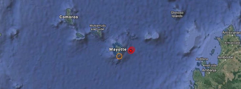
Image credit: EMSC, Google
A rare earthquake swarm started near the small Indian Ocean island of Mayotte on May 10, 2018 and continues to date. Mayotte is the oldest volcanic island in the Comoros Basin grouping and quakes likely are the result of a seismic hot spot as well as the island’s position along the East African Rift.
According to the BRGM, the France-based geological agency serving the territory, the swarm started at 05:14 UTC on May 10 and increased around 12:00 UTC with magnitudes close to 3.0. Magnitudes increased to 3.5 and 3.7 by 16:40 UTC on the same day.
The first quake felt by the population hit at 23:19 UTC, May 10 and had a magnitude of 4.5, according to the BRGM.
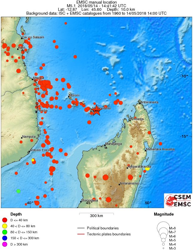
The strongest earthquake in this sequence so far was M5.1 (USGS, EMSC) registered at 14:41 UTC on May 14.
"Other earthquakes are likely to be felt by the population in the hours or days to come," BRGM said 13:00 UTC, May 14. "Magnitudes equivalent to those of Sunday and Monday morning earthquakes are still possible. These earthquakes do not produce damage and, although at sea, are too weak to generate tsunamis."
First analysis performed by the BRGM shows that all earthquakes are taking place in the same sector and there is no significant migration.
About 250 shocks were recorded in Iloni between within 24 hours to May 11 at 11:00 UTC, about 35 of magnitude greater than 3.0.
Analysis of Mamoudzou and Iloni signals show that the earthquakes are located 50 – 55 km (31 – 34 miles) away from these two stations, ie. approximately 12.6 °N, 45.7 °E.
 "Earthquakes in this swarm are of the same order of magnitude as those of 1981 and December 1985," BRGM said. "They are are part of a known and moderate seismicity in the Mozambique Channel, as can be seen in the figure below:"
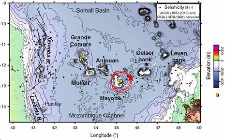
Moderate but poorly known seismicity in Mayotte
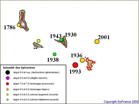
Seismicity in this region remains poorly known. A 2000 BRGM report notes that the seismicity is real as evidenced for example by the event of December 1, 1993 (epicentral intensity VII-VIII; Mb = 5.2 magnitude, depth 10 km), which fortunately occurred at sea about 40 km (25 miles) west of the main island. This earthquake is the strongest recorded in the Comoran archipelago for at least 60 years. Numerous huts in Mayotte were damaged, the agency said.
The archipelago of Comoros presents, along its 500 km (310 miles), a diffuse seismicity which probably has a double volcanic and tectonic origin. This seismicity, however, is regular with a relatively high frequency of earthquakes with magnitude close to 5 (at least five earthquakes recorded over the last 20 years: 21/5/2000 near Moheli (Mw 5.2); 23/6/2007 Bench of Geyser (Mw 5.1); 14/10/2010 North West of Grande Comore (Mw 5.2); 9/9/2011 East of Anjouan (Mw 5.0); 21/9/2016 West of Moheli (mb 5.1). On the other hand, no destructive earthquake of magnitude greater than 6 was recorded near Mayotte.
A seismic hazard study would make it possible to better understand the seismicity of the region and to estimate the return periods associated with events that could impact buildings.
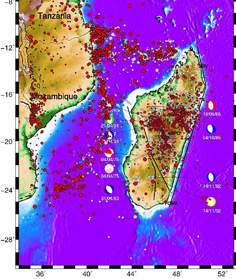
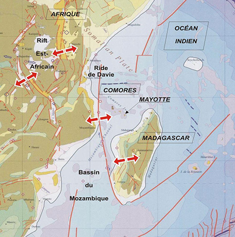
Seismotectonic context
The seismotectonic zones with notable seismicity around Mayotte are: the East African Rift, the Davie Ridge, the Mozambique Basin, the Madagascar Block and the Comoros Archipelago.
The earthquakes of the Comoros probably have a double origin which translates:
- their geodynamic position on an active hot spot;
- their probable position at the front of the deformation of the East African rift.
The oceanic crust of the Comoros basin supports the four volcanic islands of Grande Comore, Mohéli, Anjouan and Mayotte. Mayotte is the oldest volcanic island.
Today, volcanic activity is restricted to the Karthala volcano at Grande Comore. The opening of the East African rift continues at sea using the fault system of the Davie Ridge and seems to progress towards the southeast, ie. towards the Comoros and Madagascar. It is likely that this phenomenon will bring back the old faults of these two sectors, and in particular the sub-meridian faults parallel to the East African Rift and the Davie Ridge.
Analysis, data and seismotectonic context source: BRGM report published May 14, 2018
I'm a dedicated researcher, journalist, and editor at The Watchers. With over 20 years of experience in the media industry, I specialize in hard science news, focusing on extreme weather, seismic and volcanic activity, space weather, and astronomy, including near-Earth objects and planetary defense strategies. You can reach me at teo /at/ watchers.news.
Commenting rules and guidelines
We value the thoughts and opinions of our readers and welcome healthy discussions on our website. In order to maintain a respectful and positive community, we ask that all commenters follow these rules.