
First snowfall in 28 years hits parts of Florida, Georgia and South Carolina
Featured image: Florida snowfall and ice accumulation - January 3, 2018. Credit: NWS Tallahassee
A powerful winter storm brought snow, sleet, and freezing rain to parts of Florida, Georgia and South Carolina on Wednesday, January 3, 2017. Although measured amounts aren't impressive at all, compared to what regions further north are used too, in many places it was the heaviest snowfall in nearly 30 years. The storm led to numerous road closures and state of emergency declarations.
The snow, sleet, and freezing rain that marked January 3rd are over as of early January 4, but the next few days will stay very cold, NWS Tallahassee office in Florida said. Hard freeze warnings and wind chill advisories are up across our area for tonight, they added.
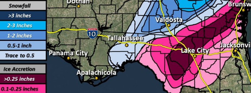
The Tallahassee measured 2.5 mm (0.1 inches) of snow on Wednesday morning, January 3, 2018, the first measurable snow since 1989. Up to 6.5 mm (0.25 inches) of ice accumulated in Lake City, Florida, between Jacksonville and Tallahassee, The Weather Channel reported, while some light freezing rain reached the western part of Duval County, and some flakes of snow were seen briefly at the NWS office in Jacksonville. Light ice accumulation on elevated surfaces and trees was seen as far south as northern Levy County, Florida.
Georgia received up to 152 mm (6 inches) of snow in Ellabell, 127 mm (5 inches) fell in Pembroke and 101.6 mm (4 inches) in Nevils. Up to 13 mm (0.5 inches) of ice accumulation was observed near Folkston and in Brunswick, Georgia.
Charleston County in South Carolina saw up to 5 mm (0.2 inches) of ice, before precipitation changed to snow during early afternoon hours, while Charleston International Airport had the third-heaviest one-day snowfall, as well as its heaviest snow event since February 10, 1973, with 134.6 mm (5.3 inches) of snow.
A strengthening Nor'easter will bring snow and gusty winds, with blizzard conditions along the coast and blowing snow elsewhere, along the Middle Atlantic and Northeast through Thursday, NWS said.
Minor to major coastal flooding and erosion will be possible, especially during high tides. In addition, dangerous travel, scattered power outages, and bitter wind chill can be expected across the entire east coast.
I'm a dedicated researcher, journalist, and editor at The Watchers. With over 20 years of experience in the media industry, I specialize in hard science news, focusing on extreme weather, seismic and volcanic activity, space weather, and astronomy, including near-Earth objects and planetary defense strategies. You can reach me at teo /at/ watchers.news.
Commenting rules and guidelines
We value the thoughts and opinions of our readers and welcome healthy discussions on our website. In order to maintain a respectful and positive community, we ask that all commenters follow these rules.