
Flash flooding expected in Mid‑Atlantic and Florida due to record moisture and slow-moving storms
Flash flood potential is elevated across several U.S. regions, with a Moderate Risk (level 3/4) in effect for the I-95 corridor in the Mid‑Atlantic from July 14 into July 15, 2025, due to a slow-moving frontal boundary and record-setting atmospheric moisture. Elevated flash flood risk also exists across the Florida Peninsula as deep tropical moisture and slow-moving storms impact the region.
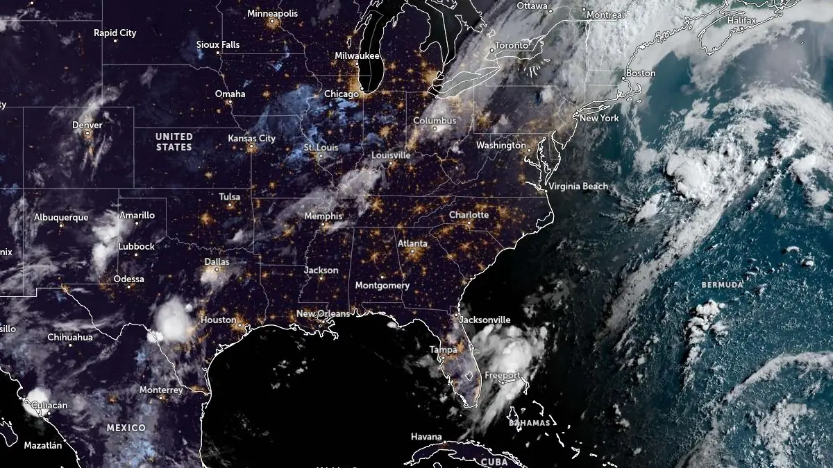
Satellite image acquired at 10:50 UTC on July 14, 2025. Credit: NOAA/GOES-East, Zoom Earth, The Watchers
A Moderate Risk of excessive rainfall was issued for portions of the Mid-Atlantic states, including parts of Virginia, Maryland, Delaware, Pennsylvania, New Jersey, and southern New York, by the U.S. National Weather Service (NWS) Weather Prediction Center (WPC), valid from 12:00 UTC on July 14 through 12:00 UTC on July 15.
A slowly advancing cold front from the Ohio Valley is forecast to reach the Mid-Atlantic and New England by evening. Numerical weather guidance agrees on widespread afternoon convection forming along a pre-frontal trough, aided by dynamic ascent from a strong vorticity maximum and favorable thermodynamics.
Precipitable water values exceeding 57 mm (2.25 inches), setting a daily record, combined with most unstable CAPE (MUCAPE) in the range of 1 000–2 000 J/kg and deep warm cloud layers around 4 270 m (14 000 feet) are expected to result in intense rainfall rates.
The High-Resolution Ensemble Forecast (HREF) indicates 30–50% probability of hourly rates reaching or exceeding 50 mm (2 inches), with localized bursts potentially over 75 mm (3 inches).
Forecast totals are expected to reach 50–100 mm (2–4 inches) widely, with localized amounts exceeding 125 mm (5 inches), particularly where training occurs.
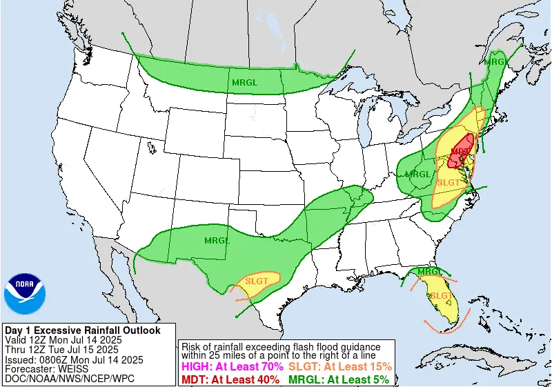
Model agreement supports this high-impact setup, especially along the I-95 corridor from Richmond, Virginia to New York City. Multiple ensemble systems, including the CSU First-Guess field and the ECMWF Extreme Forecast Index, highlight this corridor as at high risk. This signature, combined with antecedent wet conditions and vulnerable soils, led to coordination with local Weather Forecast Offices and a Moderate Risk upgrade.
Additional heavy rainfall potential exists across the Florida Peninsula, where a westward-advancing tropical wave and inverted mid-level trough will interact with high precipitable water and surface instability above 2 000 J/kg. Thunderstorm development is expected to intensify through the afternoon, with rainfall rates of 50–75 mm/hr (2–3 inches/hr).
While storms will initially favor the Atlantic coast, convective activity is expected to spread inland and then shift southwestward through the day. A secondary round of storms may impact eastern coastal areas after 03:00 LT on July 15. Rainfall totals are expected to reach 75–125 mm (3–5 inches) with localized higher amounts, especially in urban areas where short-duration training occurs.
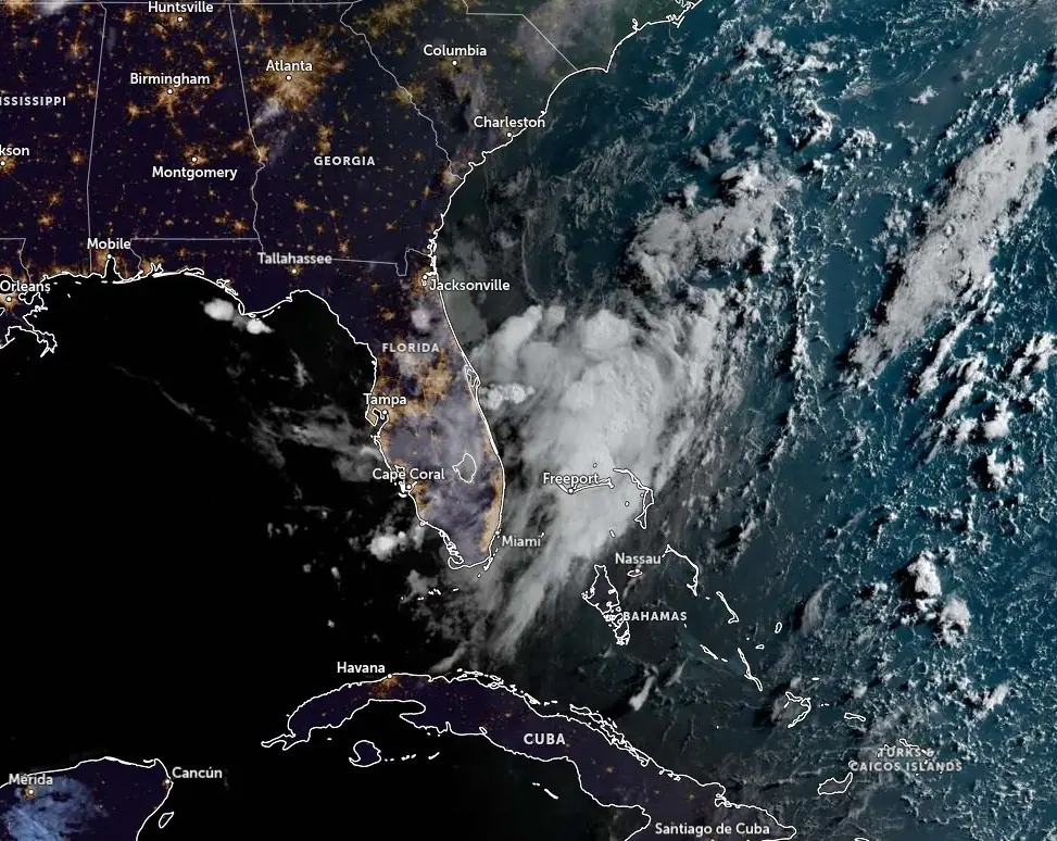
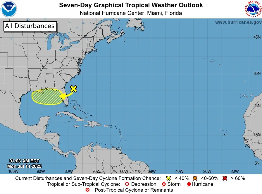
The National Hurricane Center (NHC) is monitoring a trough of low pressure along the Atlantic Coast, forecast to move westward across Florida during the next day or so, and into the northeastern Gulf by late Tuesday, July 15.
Environmental conditions appear favorable enough to support some gradual development of this system while it moves westward to west-northwestward across the northeastern and north-central portions of the Gulf during the middle to latter part of this week.
“Regardless of development, heavy rainfall could produce localized flash flooding over portions of Florida and the north-central Gulf coast through the middle to latter portion of this week,” NHC forecaster Hagen noted.
In the Desert Southwest through the Mid-Mississippi Valley, an upper-level ridge with embedded shortwave disturbances will generate scattered but intense convective activity from Arizona and New Mexico into Texas and the Ozarks. Precipitable water values in this region will range from 30–50 mm (1.25–2 inches), and afternoon MUCAPE is expected to reach 1 000–2 000 J/kg. The resulting convection could produce localized rainfall rates of 25–75 mm/hr (1–3 inches/hr), with enhanced potential over southeastern Arizona and southwestern New Mexico due to favorable overlap of dynamics and moisture.
Although satellite analysis indicates morning cloud cover, forecast models suggest a 60% probability of 25 mm (1 inch) totals, with isolated areas possibly reaching 75 mm (3 inches). A Slight Risk remains in effect due to uncertainty in storm regeneration.
Another region of concern is the Texas Hill Country into the Ozarks, where a stalled front and an approaching mesoscale convective vortex from northern Mexico may trigger heavy convection in an environment with extremely high soil saturation and favorable convergence.
Model spread is large here, but several CAMs highlight the potential for enhanced rainfall totals. Forecast rainfall totals could reach or exceed 75 mm (3 inches) locally. A Slight Risk has been added for this region following coordination with Weather Forecast Offices in San Angelo and Austin/San Antonio.
Over the Northern Plains, a developing upper trough over southern Canada will push a cold front into a moist and unstable environment later in the day. Precipitable water values are expected to exceed the 90th percentile, and a strengthening low-level jet of 25–35 kt will enhance moisture advection into the region. Convective development is expected along the front, supported by ascent and parallel wind profiles that could support training storms.
Although storm motions will remain generally progressive, hourly rainfall rates of 25–50 mm (1–2 inches) and isolated totals above 75 mm (3 inches) could occur, with greatest impacts expected in the evening hours. Model-derived exceedance probabilities suggest isolated flash flooding is possible.
References:
1 Short Range Forecast Discussion – NWS/WPC – July 14, 2025
2 WPC Day 1 Excessive Rainfall Outlook – NWS/WPC – July 13, 2025
3 Tropical Weather Outlook – NWS/NHC – July 14, 2025

I’m a science journalist and researcher at The Watchers, contributing to the Epicenter edition, where I cover peer-reviewed scientific research and emerging discoveries across Earth and space sciences. With a background in astronomy and a passion for environmental science, I’ve worked in shark and coral conservation in Fiji, conducting reef and shark-behavior research, contributing to mangrove restoration, and earning PADI Open Water and Coral Reef Certifications. I bring a blend of scientific rigor and storytelling to illuminate the discoveries shaping our planet and beyond.
Commenting rules and guidelines
We value the thoughts and opinions of our readers and welcome healthy discussions on our website. In order to maintain a respectful and positive community, we ask that all commenters follow these rules.