
NWS confirmed EF-2 tornado in Scott County, Iowa as rare flash flood emergency hit Quad Cities
An EF-2 tornado struck Davenport, Iowa at 17:03 CDT (22:03 UTC) on July 11, 2025, with peak winds of 193 km/h (120 mph), according to the National Weather Service. On the same day, a rare Flash Flood Emergency was declared for the Quad Cities region after 109.2 mm (4.3 inches) of rainfall.
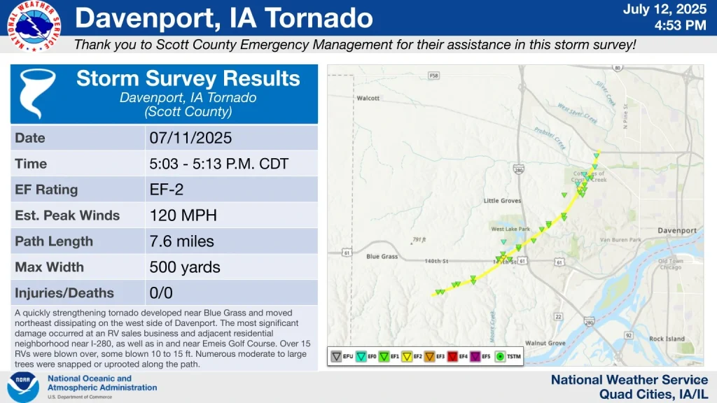
NWS in Quad Cities, Iowa/Illinois, conducted a damage survey following severe weather on July 11, confirming an EF-2 tornado in Scott County, Iowa. The tornado developed southeast of Blue Grass and remained on the ground for 10 minutes, from 17:03–17:13 LT, traveling 12.2 km (7.60 miles) with maximum winds estimated at 193 km/h (120 mph).
According to the NWS, the tornado’s path reached up to 457 m (1 500 feet) in width. Significant damage was observed at an RV sales business near Interstate 280 and in the adjacent residential areas and Emeis Golf Course. More than 15 RVs were overturned or displaced, some by up to 4.6 m (15 feet), including a 11 340 kg (25 000 lb) vehicle. Over 80 trees were snapped or uprooted, many in concentrated areas. Two unoccupied vehicles were reported damaged by falling trees.
No injuries or fatalities were reported.
The tornado was part of a broader convective system that also produced a rare Flash Flood Emergency in the Quad Cities later that evening, marking one of the few times such an alert was issued for this region.
Rainfall totals reached 109.2 mm (4.3 inches) in Davenport, with intense downpours leading to rapid rises in Duck Creek and widespread urban flooding. Roads became impassable and multiple vehicles were submerged.
The NWS also confirmed a second tornado in Missouri, rated EF-0, based on radar and ground assessments. This tornado touched down near Strasburg in Cass County at 20:21 LT on July 11, and remained on the ground for about two minutes. It traveled 1.2 km (0.77 miles) with a maximum width of 183 m (200 yards), causing minor tree damage along Route 58 and surrounding farmland.
Both tornadoes were associated with a convective weather system that affected parts of the central United States during the afternoon and evening hours.
References:
1 National Weather Service Raw Text Product – NWS – July 12, 2025
Featured image credit: Live Storms Media (stillshot)

I’m a science journalist and researcher at The Watchers, contributing to the Epicenter edition, where I cover peer-reviewed scientific research and emerging discoveries across Earth and space sciences. With a background in astronomy and a passion for environmental science, I’ve worked in shark and coral conservation in Fiji, conducting reef and shark-behavior research, contributing to mangrove restoration, and earning PADI Open Water and Coral Reef Certifications. I bring a blend of scientific rigor and storytelling to illuminate the discoveries shaping our planet and beyond.
Commenting rules and guidelines
We value the thoughts and opinions of our readers and welcome healthy discussions on our website. In order to maintain a respectful and positive community, we ask that all commenters follow these rules.