
Rare Moderate Risk (4/5) issued for Mid-Atlantic as severe thunderstorms raise threat of damaging winds and tornadoes
A Moderate Risk (Level 4 of 5) for severe thunderstorms has been issued across parts of the Mid-Atlantic United States for Monday, March 16, 2026, as a powerful storm system affects much of the country. Fast-moving thunderstorms may become widespread during the afternoon and evening from the Carolinas into Virginia and Maryland, bringing damaging wind gusts and a few tornadoes, with the potential for a couple of storms to produce strong and long-track tornadoes.
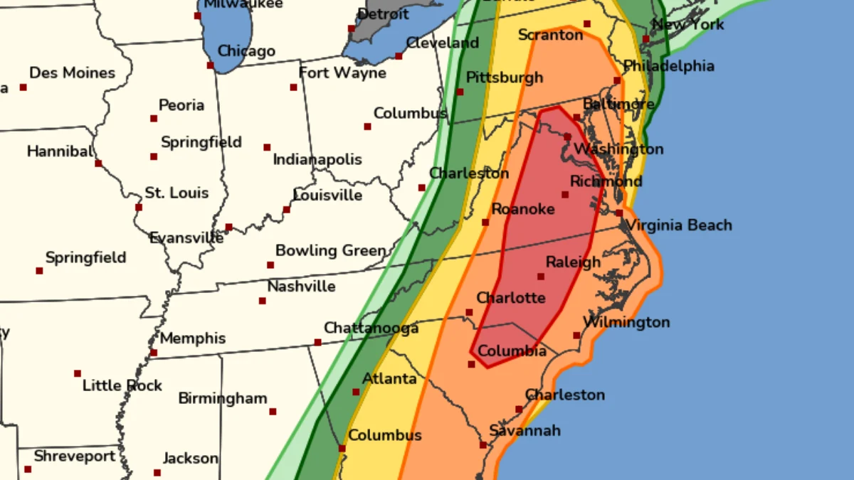
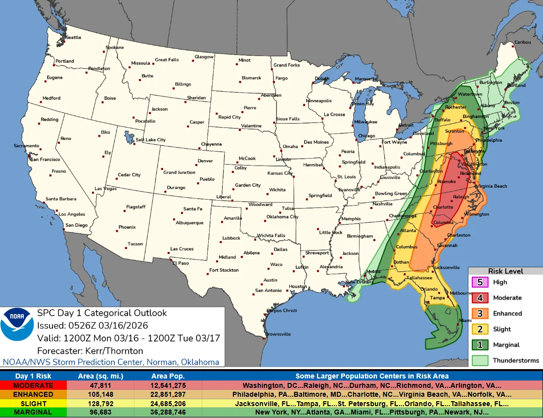
Image credit: NOAA/SPC
The Storm Prediction Center (SPC) issued a Moderate Risk (Level 4 of 5) outlook valid from 12:00 UTC on March 16 to 12:00 UTC on March 17, citing the risk of severe thunderstorms capable of producing damaging wind gusts and tornadoes across parts of the Mid-Atlantic.
A Moderate Risk is one of the higher categories in SPC’s five-level severe weather outlook system. Ahead of the event, the National Weather Service office serving the Washington, D.C. area described the setup as a “quite rare Day 2 Moderate Risk area.”
The Moderate Risk area covers central Maryland, much of central and eastern Virginia, central North Carolina, and adjacent portions of South Carolina, where atmospheric conditions will support fast-moving thunderstorms during the afternoon and evening hours.
Meanwhile, an Enhanced Risk (level 3/5) expands from Pennsylvania to Georgia, while a Slight (level 2/5) and a Marginal (level 1/5) stretch from New York to Florida.
The severe weather threat is associated with a large storm system affecting much of the United States. The broader system is forecast to produce severe thunderstorms, widespread strong winds, heavy snow in northern regions, and sharp temperature drops in parts of the northern and eastern United States.
The risk areas include major metropolitan cities such as Washington, D.C., Richmond, Virginia, and Raleigh, North Carolina, increasing the potential societal impact if severe storms develop as expected.
Forecast models show a short-wave disturbance embedded within a larger trough over the central United States will pivot toward the Cumberland Plateau during the day before rapidly accelerating northeast toward Quebec later in the evening and overnight hours.
This disturbance is expected to support the development of a rapidly deepening secondary surface cyclone over Quebec, while a trailing cold front advances eastward across the Appalachian region toward the Atlantic coast.
Ahead of the cold front, low-level moisture is returning northward along the Atlantic Seaboard, with surface dew points forecast to exceed 16°C (60°F) across parts of the Mid-Atlantic and reach 18 to 19°C (mid-60s°F) across eastern North Carolina and Virginia.
Although forecast instability remains modest, with convective available potential energy (CAPE) values of approximately 500–1 000 J/kg, the atmosphere is expected to feature very strong wind shear, which significantly increases the potential for rotating thunderstorms.
Forecasts show a deep-layer southwesterly flow of approximately 93–111 km/h (58–69 mph) along with strong low-level directional shear. These wind profiles favor the development of organized supercells capable of producing tornadoes, particularly during the early stages of storm development.
A few supercells may produce strong tornadoes, with storm motions fast enough to support longer-track tornado paths, if storms remain discrete during the afternoon.
Later in the event, thunderstorms may consolidate into a pre-frontal squall line, which could produce widespread damaging wind gusts as strong winds from higher levels of the atmosphere are transported to the surface.
Farther south along the Atlantic coastal states, a pre-existing line of storms may persist or re-intensify, maintaining a risk for severe wind gusts and embedded tornadoes.
References:
1 Day 1 convective outlook – SPC – March 16, 2026

I am an Assistant Editor and Severe Weather & Science Journalist at The Watchers, specializing in real-time severe weather coverage, geophysical event reporting, and research-driven scientific analysis. You can reach me at rishav(at)watchers(.)news.
Commenting rules and guidelines
We value the thoughts and opinions of our readers and welcome healthy discussions on our website. In order to maintain a respectful and positive community, we ask that all commenters follow these rules.