
Ex-cyclone Debbie wreaks havoc across North Island, New Zealand
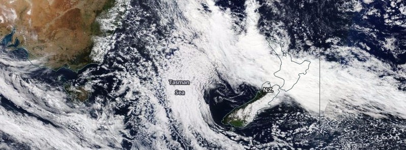
Featured image: Ex-cyclone Debbie over Tasman Sea affecting New Zealand on April 4, 2017. Credit: NASA Terra/MODIS
Remnants of Tropical Cyclone "Debbie" have reached New Zealand and are now dumping flooding rain across the North Island. Parts of the region have declared states of emergency and are expecting record flooding Wednesday. The storm will continue affecting the country on Wednesday and move to the east of New Zealand on Thursday, April 6, 2017. Weather is expected to settle down over the country on Friday and continue through to Sunday.
A deep low affecting New Zealand today and Wednesday, April 5 is expected to move southeastwards to the east of New Zealand on Thursday, New Zealand's MetService said.
Heavy rain has already fallen in many places and is expected to continue until the passage of the low early Thursday morning. The heaviest rain is expected from Northland to Whanganui, including Coromandel Peninsula, Bay of Plenty, the Central North Island High Country, Gisborne, Hawkes Bay, Wairarapa and the Kaikoura Coast. Rainfall totals could exceed 250 mm (9.84 inches) in some areas, the service said. There is also a potential for thunderstorms and downpours with hourly rainfall rates of 25 to 45 mm (0.98 – 1.77 inches).
This is a significant amount of rain and people are advised to watch out for rapidly rising rivers and streams, flooding and slips, it said.
In addition, strong southeasterly winds are forecast about central New Zealand. Horowhenua Kapiti Coast, Nelson and Buller are expected to have the strongest winds, where gusts could reach 120 km/h (74.5 mph) in exposed places for a time during Wednesday. Winds of this strength could cause damage to trees, powerlines and unsecured structures and make driving hazardous.
Civil Defence warns residents to take shelter indoors, preferably away from windows, and to secure any loose objects around your property.
Record flooding expected in Whanganui, Rangitikei
Whanganui Mayor Hamish McDouall has signed a declaration of a state of emergency for the region.
According to Radio New Zealand, a record flooding is expected in Whanganui and Rangitikei on Wednesday and residents are being urged to evacuate at-risk areas before the worst hits.
The Whanganui District Council said its modeling suggested that the Whanganui River, New Zealand's longest navigable waterway, would rise to 19.3 m (63.3 feet) at Pipiriki by about 13:00 local time on Wednesday, about 4 m (13.1 feet) above the level of devastating floods of June 2015.
"We didn't have time in 2015 but we have about 20 hours to save your precious things, maybe raise things, maybe check on your elderly neighbor," McDouall said.
Other rivers were also expected to surpass previous flood levels, the Horizons Regional Council said. "The Whangaehu is expected to peak at 15.3 m (50.2 feet) at 15:00, which is 4 m higher than 2004, and is likely to close State Highway 3 at approximately 11:00. The Turakina is expected to peak at 11.6 m (38 feet) at 18:45."
All schools and early childhood centers in the two districts would be closed on Wednesday, and would remain closed until the states of emergency lifted, the Ministry of Education said.
Heavy rain warnings were also in place for Gisborne, Coromandel, Hawke's Bay, Taranaki, Auckland and Wairarapa.
Cliff collapse in Auckland
In Auckland, New Zealand's largest city, about 20 residents were evacuated around 20:00 NZDT today after a cliff collapsed into the San Remo apartment complex, in the coastal residential area of Kohimarama. Initial reports mentioned two people were missing after the collapse but police later confirmed everybody was accounted for.
The cliff collapse occurred as the Fire Service was dealing with multiple flooding incidents.
Five homes on Auckland's Whangaparāoa Peninsula were also evacuated due to a 50 m (164 feet) long and 20 m (64 feet) wide landslide.
According to Auckland Civil Defence, heavy rainfall had caused localized flooding and small slips in other parts of the city too. The eastern suburbs and Waiheke were the worst hit by rain, including St Heliers, Beachlands, Remuera, Otara and Howick.
I'm a dedicated researcher, journalist, and editor at The Watchers. With over 20 years of experience in the media industry, I specialize in hard science news, focusing on extreme weather, seismic and volcanic activity, space weather, and astronomy, including near-Earth objects and planetary defense strategies. You can reach me at teo /at/ watchers.news.
Commenting rules and guidelines
We value the thoughts and opinions of our readers and welcome healthy discussions on our website. In order to maintain a respectful and positive community, we ask that all commenters follow these rules.