
Tropical Storm “Noul” nears Yap, Western Pacific Ocean
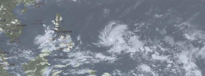
Featured image: Tropical Storm "Noul" on May 4, 2015. Image credit: UW-CIMSS
Tropical Storm "Noul" formed in the Western Pacific Ocean on May 4, 2015 and is heading toward Yap Island, Micronesia. The system is expected to significantly intensify over the coming days.
According to JTWC's warning issued 03:00 UTC today, Tropical Storm "Noul" was located approximately 242 km (150 miles) east of Yap, and has tracked WNW at 7.4 km/h (4.6 mph) over the past six hours. Maximum significant wave height at 00:00 UTC today was 3 meters (10 feet).
At the same time, its maximum sustained winds were about 64 km/h (40 mph), with wind gusts up to 83 km/h (51 mph).

Tropical Storm "Noul" forecast track by JTWC on May 4, 2015.
According to NWS Guam, a Tropical Storm Warning is in effect for Yap Island, Fais and Ulithi in Yap State. Tropical storm conditions, including damaging winds of 62 km/h (39 mph) or more, are occurring at Fais and Ulithi.

Tropical Storm "Noul" forecast track by NWS Guam on May 4, 2015.

Video credit WestPacWx.

Tropical Storm "Noul" on May 4, 2015. Image credit: UW-CIMSS
Satellite animations
- Storm-Centered Infrared (MTSAT; NOAA/SSD)
- Storm-Centered Infrared (Aviation Color Enhancement) (MTSAT; NOAA/SSD)
- Storm-Centered Water Vapor (MTSAT; NOAA/SSD)
- Storm-Centered Visible (MTSAT; NOAA/SSD)
- Storm-Centered Visible (Colorized) (MTSAT; NOAA/SSD)
- Storm-Centered Infrared (MTSAT2; CIMSS)
- Storm-Centered Enhanced Infrared (MTSAT2; CIMSS)
- Storm-Centered Water Vapor (MTSAT2; CIMSS)
- Storm-Centered Visible (MTSAT2; CIMSS)
- Tropical West Pacific Infrared (MTSAT2; NOAA)
- Tropical West Pacific Enhanced Infrared (MTSAT2; NOAA)
- Tropical West Pacific Water Vapor (MTSAT2; NOAA)
- Tropical West Pacific Visible (MTSAT2; NOAA)

Teo Blašković founded The Watchers in 2011 and edited it until 2026, covering seismic and volcanic activity, extreme weather, space weather and near-Earth objects. Articles on this page are his archive.
Published in the last 24 hours
- Cyclone Akvan weakens after landfall near Gopalpur; more than 300 000 evacuated in Odisha, India
- High Risk of excessive rainfall covers Florida’s Space Coast as St. Johns River near Cocoa reaches 5.67 m
- Four small asteroids will pass close to Earth from November 21 to 23
- A broad low over southeastern Florida and the northwestern Bahamas has a 30 percent chance of subtropical or tropical development within 48 hours and a 50 percent chance within 7 days, the National Hurricane Center says



