
Evacuation Warnings issued for Palisades and Eaton burn scars ahead of high-impact winter storm in California
Evacuation Warnings were issued for residents living near the Palisades and Eaton burn scar areas in Los Angeles County, California, effective from 21:00 LT (05:00 UTC) on Sunday, February 15, through 09:00 LT (17:00 UTC) on Tuesday, February 17, 2026, ahead of a winter storm forecast to bring heavy rainfall. Officials warned that debris flows and mudflows could damage property and pose life-threatening risks in recently burned areas. Winter storm warnings were also issued across parts of California and Nevada for heavy mountain snowfall and strong winds.
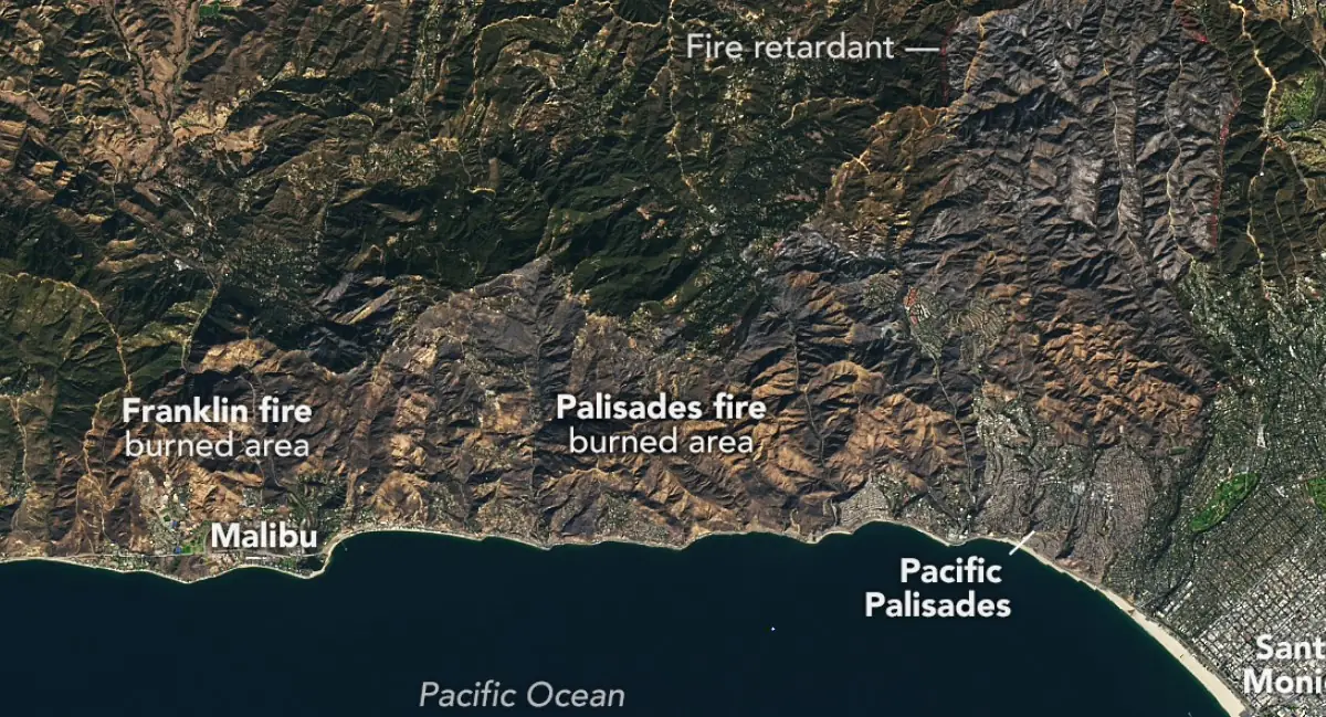
Palisades fire burned area, California. Credit NASA/Earth Observatory
Los Angeles officials issued Evacuation Warnings to those living in the Palisades and Eaton burn scar areas ahead of the upcoming winter storm expected to bring heavy rainfall.
“Evacuation Warnings are in effect for select parcels near recent burn areas, valid from Sunday, February 15, at 21:00 local time (LT) through Tuesday, February 17, at 09:00 LT, due to anticipated weather conditions that present a risk of debris and mudflows that can damage property and pose a risk to personal safety,” said the LA County Government.
“Recent burn areas should maintain awareness of nearby conditions. Areas near the Canyon, Bethany, Eaton, Palisades, Kenneth, Sunset, Lidia, Hurst, Franklin, and Bridge Fires should prepare to evacuate in the event an Evacuation Order is issued,” they added.
“Significant snow is expected & mountain travel discouraged Sun-Wed. If you must travel, expect delays and chain controls in the Sierras,” said Caltrans.
“When rainstorms impact the Los Angeles area, storm drains, canyons, arroyos, and other sloped or low-lying areas can quickly fill with fast-moving water and debris, creating a life threatening danger,” the Los Angeles Fire Department said.
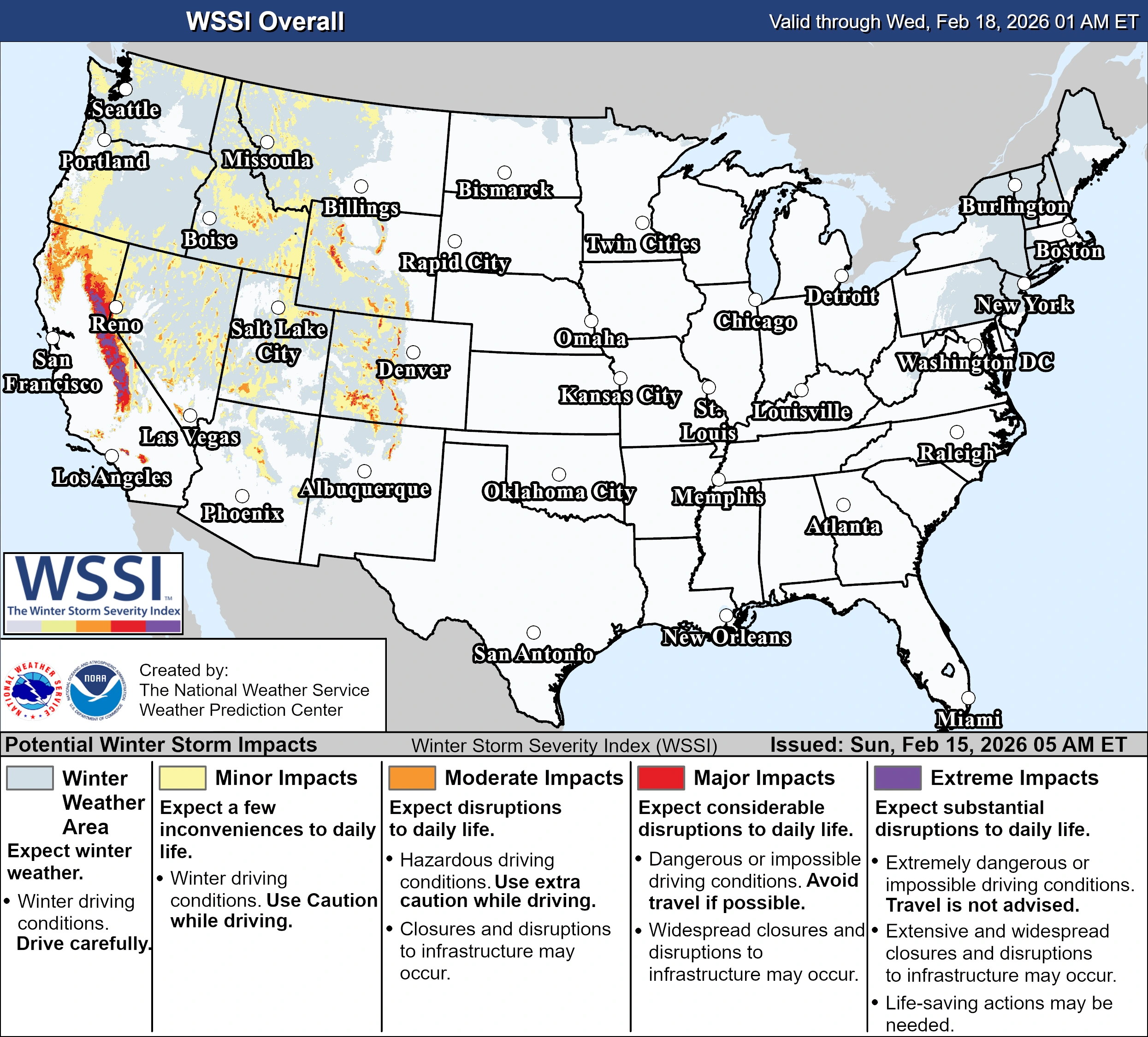
Winter storm warnings were issued by the National Weather Service (NWS) offices in Hanford, Las Vegas, Eureka, Medford, Reno, Sacramento, and Fairbanks beginning late February 14 and early February 15.
In central California, the NWS Hanford office reported heavy snow with accumulations of 0.9–1.5 m (3–5 feet) above 1 830 m (6 000 feet), locally reaching 1.5–2.1 m (5–7 feet) over the highest elevations, and 30–60 cm (1–2 feet) down to 1 220 m (4 000 feet).
Wind gusts were forecast to reach up to 95 km/h (60 mph). The warning remains in effect from 22:00 PST on February 15 to 22:00 PST on February 18.
Along the Eastern Sierra Slopes, the NWS Las Vegas office forecasts snowfall exceeding 0.9 m (3 feet) above 2 440 m (8 000 feet), 45–75 cm (1.5–2.5 feet) above 2 130 m (7 000 feet), and 20–40 cm (8–16 inches) down to 1 830 m (6 000 feet).
Wind gusts may reach 110 km/h (70 mph), with visibility potentially dropping below 400 m (0.25 miles) due to blowing snow.
In Mono County and the Greater Lake Tahoe Area, the NWS Reno office warned of 0.6–0.9 m (2–3 feet) of snow in the Tahoe Basin, with 0.9–1.5 m (3–5 feet) above 2 130 m (7 000 feet) and ridge gusts exceeding 160 km/h (100 mph). Lower valleys along and east of U.S. Highway 395 are forecast to receive 5–15 cm (2–6 inches).
Northern California and the coastal ranges are also under warnings. The NWS Sacramento office forecasts accumulations of up to 30 cm (1 foot) at 600–760 m (2 000–2 500 feet), 30–60 cm (1–2 feet) at 760–1 070 m (2 500–3 500 feet), and 1.2–2.4 m (4–8 feet) at higher elevations, with gusts of 70–90 km/h (45–55 mph).
Snow levels are forecast to fall from 1 350–1 675 m (4 500–5 500 feet) Sunday night to 450–760 m (1 500–2 500 feet) from Tuesday into Wednesday.
In southwestern Humboldt and interior Del Norte and Trinity counties, the NWS Eureka office forecasts 15–40 cm (6–15 inches) above 600 m (2 000 feet), locally reaching 30–75 cm (1–2.5 feet) above 900 m (3 000 feet), with gusts up to 65 km/h (40 mph).
In western and central Siskiyou County, the NWS Medford office forecasts 20–30 cm (8–12 inches) above 1 520 m (5 000 feet) through Monday morning, with an additional 15–30 cm (6–12 inches) expected as snow levels fall to 600 m (2 000 feet) by Tuesday morning.
References:
1 Winter Storm Warning – NWS – February 15, 2025

I am an Assistant Editor and Severe Weather & Science Journalist at The Watchers, specializing in real-time severe weather coverage, geophysical event reporting, and research-driven scientific analysis. You can reach me at rishav(at)watchers(.)news.
Commenting rules and guidelines
We value the thoughts and opinions of our readers and welcome healthy discussions on our website. In order to maintain a respectful and positive community, we ask that all commenters follow these rules.