
Category 4 Hurricane Melissa forecast to strike Jamaica with powerful winds, catastrophic flash flooding, and life-threatening storm surge
Hurricane Melissa reached Category 4 strength on October 26, 2025, after causing three fatalities in Hispaniola earlier this week. The system could reach Category 5 strength by tonight, before making landfall in Jamaica late on October 27 or early on October 28, bringing rainfall totals of up to 1 000 mm (40 inches) by October 29.

Civil protection agencies in Hispaniola inspecting areas flooded by heavy rains from Hurricane Melissa on October 25, 2025. Credit: Defensa Civil Dominicana
Key messages from NHC:
- Jamaica: Seek shelter now. Damaging winds and heavy rainfall today and on Monday will cause catastrophic and life-threatening flash flooding and numerous landslides before the strongest winds arrive Monday night and Tuesday morning. Extensive infrastructural damage, long-duration power and communication outages, and isolation of communities are expected. Life-threatening storm surge is likely along portions of the southern coast Monday night and Tuesday morning.
- Haiti: Catastrophic and life-threatening flash flooding and landslides are expected across southwestern Haiti through midweek, likely causing extensive infrastructural damage and isolation of communities. Although winds are temporarily decreasing on the Tiburon peninsula, they could increase again across much of western Haiti on Tuesday.
- Dominican Republic: Heavy rainfall through midweek could produce catastrophic flash flooding and numerous landslides in southern portions of the country.
- Eastern Cuba, Southeast Bahamas, and the Turks and Caicos: Monitor Melissa closely. There is an increasing risk of a significant storm surge, damaging winds, and heavy rainfall by the middle of the week. In eastern Cuba, the risk of life-threatening flash flooding and landslides is increasing. A Hurricane Watch is in effect for portions of eastern Cuba.
Melissa rapidly strengthened into a Category 4 hurricane on October 26, less than 24 hours after it became a hurricane on October 25.
Melissa has already claimed three lives in Haiti earlier this week, when the storm stalled in the Caribbean, dropping heavy rainfall, and triggering deadly floods and landslides across Hispaniola.
Haiti’s Civil Protection Agency confirmed that a landslide in Fontamara, a commune of Port-au-Prince, left two people dead on October 23, and a falling tree killed a man in his 70s in Marigot during flooding on October 22.
In Praville, Gonaïves (Artibonite), a wall collapse injured fifteen people. Among the victims were eight women and girls, including a 14-year-old girl who was seriously injured.
At least 342 shelters were opened in the Southeast, South, and Grand’Anse departments in southern Haiti due to the storm.
A section of road in Moron, Grand’Anse, was cut off by residents of the commune, making traffic to five municipalities — Les Irois, Anse-d’Hainault, Dame-Marie, Chambellan, and the city center of Moron — nearly impossible. Public Works teams are preparing to intervene to restore access.
The flooding of the Artibonite River has paralyzed border trade activities in Belladère, located in the Central Department.
Authorities warned locals not to swim in the floodwaters after videos of people diving into the floodwaters from their roofs went viral on social media.
Relief efforts have also been hindered in many department’s that are under the control of armed gangs. These include the communes of Petite-Rivière de l’Artibonite, L’Estère, and La Chapelle. In the Central Department, no information has been received from Saut-D’Eau, which is also under gang control, according to Haiti’s Civil Protection Agency.
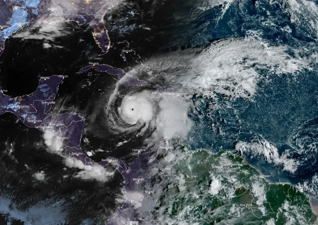
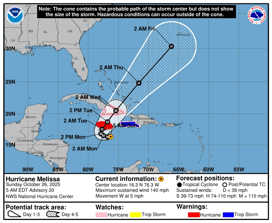
As of 05:00 EDT (09:00 UTC) on October 26, the system was located 354 km (220 miles) south-southeast of Kingston, Jamaica, and 450 km (280 miles) south-southwest of Guantánamo, Cuba.
Maximum sustained winds (averaged over 1-minute) reached 220 km/h (136 mph). Melissa was moving westward at 7 km/h (4 mph), with an estimated minimum central pressure of 944 hPa.
Hurricane-force winds extend outward up to 35 km (21 miles) from the center, while tropical-storm-force winds extend outward up to 280 km (174 miles).
The system is forecast to continue its slow westward movement through October 26, and turn north-northeast on October 27 and 28. It could reach Category 5 strength later on the night of October 26 before it begins to weaken.
“An eyewall replacement would be likely to occur at some point over the next couple of days, which would cause a decrease or at least fluctuations in Melissa’s intensity after 24 hours,” said the National Hurricane Center (NHC).
Melissa is forecast to make landfall over Jamaica’s southern coast by the night of October 27 or the morning of October 28, as a major Category 4 hurricane. The storm should weaken following landfall due to interaction with the rugged terrain.
However it is expected to maintain major hurricane strength (Category 3 or higher) as it reaches southeastern Cuba by late October 28, and southeastern Bahamas by October 29.
“It’s assumed that the current period of rapid intensification will continue, and Melissa could reach category 5 intensity by tonight,” NHC forecaster Berg said.
“An eyewall replacement would be likely to occur at some point over the next couple of days, which would cause a decrease or at least fluctuations in Melissa’s intensity after 24 hours. Regardless, Melissa is forecast to reach Jamaica as a category 4 hurricane, which will only compound any damages caused by heavy rainfall and flooding over the next 2 days.”
Rainfall totals of 381 to 762 mm (15 to 30 inches) are forecast for parts of southern Hispaniola and Jamaica by October 29, with localized totals of up to 1 000 mm (40 inches). Rainfall totals of 151–305 mm (6–12 inches) are forecast across eastern Cuba, with localized totals of up to 460 mm (18 inches) within the same timeframe.
The heavy rainfall is likely to trigger life-threatening floods and landslides across the affected region. While additional rainfall is expected to continue after October 29, it is still too early to forecast rainfall totals for the time.
The Jamaican government said that it activated the country’s emergency operation center and emergency generators, medical supplies, and fuel are in place ahead of the storm.
“We have over 50 generators ready to go and to be deployed so that within 72 hours of a storm, 80% of NWC customers will be able to get back portable water,” Matthew Samuda, Minister of Water, Environment and Climate Change, said during a press conference on October 24. “This is a marked difference from the last time around.”
Kingston’s Norman Manley International Airport was closed at 21:00 local time on October 25, canceling over 20 flights till October 28.
A Hurricane Warning is in effect for Jamaica. Meanwhile, a Hurricane Watch is in effect for the southwestern peninsula of Haiti from the border with the Dominican Republic to Port-Au-Prince, and the Cuban provinces of Granma, Santiago de Cuba, Guantánamo, and Holguín.

I am an Assistant Editor and Severe Weather & Science Journalist at The Watchers, specializing in real-time severe weather coverage, geophysical event reporting, and research-driven scientific analysis. You can reach me at rishav(at)watchers(.)news.
Commenting rules and guidelines
We value the thoughts and opinions of our readers and welcome healthy discussions on our website. In order to maintain a respectful and positive community, we ask that all commenters follow these rules.