
1 dead in Florida due to rip currents generated by Hurricane Humberto and Tropical Storm Imelda
One person was confirmed dead in Volusia County, Florida due to rip currents generated by Tropical Storm Imelda, and Hurricane Humberto in the Atlantic. Humberto is forecast to continue producing rip currents across the entire East Coast as Imelda intensifies.

Satellite image of Tropical Storm Imelda and Hurricane Humberto as of 17:50 UTC on September 29, 2025. Credit: NOAA/GOES-East, Zoom Earth, The Watchers
A 51-year old man was confirmed dead after being pulled into the ocean by rip currents in Florida, on September 27.
The fatality was confirmed by the Volusia County Sheriff’s Office. The man was out of state visitor who drowned after getting pulled into oceans by rip currents.
“Not a good time to be in the water, and the storm offshore is not going to make conditions any better,” said the Volusia Sheriff’s Office.
Beaches across Florida are experiencing rip currents due to Tropical Storm Imelda and Hurricane Humberto. The National Weather Service has issued rip current risks for beaches along almost the entire East Coast from the Gold Coast of Florida to Maine due to swells generated by both tropical threats.
Storm surge levels along the coastline of the Volusia County are forecast to rise by 30 to 60 cm (1 to 2 feet) on September 29.

A high rip current risk is in effect from Fort Lauderdale, Florida, through North Carolina. A moderate risk covers the mid-Atlantic, including Maryland, Delaware, and New Jersey beaches. Meanwhile, a low rip current risk covers the south shore of New York’s Long Island through Maine.
Local NWS offices have also issued Small Craft Advisories for much of the same areas along the East Coast, warning inexperienced boaters and mariners operating small boats to stay out of the water due to rough waves and gusty winds.
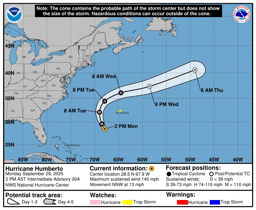
As of 11:00 AST (15:00 UTC) on September 29, Hurricane Humberto was located approximately 547 km (340 miles) south-southwest of Bermuda. Maximum sustained winds (averaged over 1-minute) reached 233 km/h (145 mph). It was moving northwestward at 20 km/h (13 mph), with an estimated minimum central pressure of 940 hPa.
Swells generated by Hurricane Humberto will create life-threatening rip currents for parts of the northern Leeward Islands, the Virgin Islands, Puerto Rico and Bermuda through much of this week.
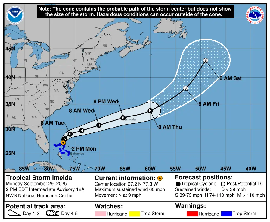
At the same time, Tropical storm Imelda was located about 56 km (35 miles) north of Great Abaco Island and roughly 386 km (240 miles) off Cape Canaveral, Florida. Maximum sustained winds (averaged over 1-minute) were reaching 97 km/h (60 mph).
Imelda was moving northward at 14 km/h (9 mph), and will continue to move in that general direction through September 29. A sharp turn to the east-northeast is forecast on September 30, as it reaches hurricane strength.
The system is expected to start moving away from the northwestern Bahamas today and then turn east-northeastward, moving away from the southeastern U.S. by the middle part of this week, but approaching the island of Bermuda.
Imelda is already affecting the northwestern portions of the Bahamas, with a gust of 134 km/h (83 mph) being observed at Treasure Kay. Tropical storm conditions are expected to continue over the island through September 29.
A Tropical Storm Warning is in effect for Portions of the Northwestern Bahamas, including Eleuthera, the Abacos, Grand Bahama Island and the surrounding keys.
The storm is forecast to produce 100 to 200 mm (4 to 8 inches) of rainfall across northwestern Bahamas through September 30, potentially triggering floods in urban areas.
Rainfall totals of 25–50 mm (1–2 inches), with locally higher totals of up to 200 mm (8 inches) are forecast for northeast Florida, coastal South Carolina, and coastal sections of southeast North Carolina. The heavy rainfall is likely to trigger urban flooding, especially in areas with poor drainage.
Storm surge will raise water levels by as much as 30 to 90 cm (1 to 3 feet) above ground level along the immediate coast in areas of onshore winds in the northwestern Bahamas. Near the coast, the surge will be accompanied by large waves.
Minor coastal flooding is possible in areas of onshore winds over the Southeastern U.S. coastline. Water levels along the Volusia/Brevard County Line, Florida to the South Santee River, South Carolina are forecast to rise by 30 to 60 cm (1 to 2 feet) on September 29.
Swells generated by Tropical Storm Imelda and Hurricane Humberto are affecting the Bahamas and will spread to much of the east coast early this week, causing life-threatening surf and rip current conditions.
References:
1 Tropical Storm Imelda Advisory Number 12 – NHC – September 29, 2025.
2 Hurricane Humberto Advisory Number 20 – NHC – September 29, 2025
3Rip Current Statement – NWS – September 29, 2025

I am an Assistant Editor and Severe Weather & Science Journalist at The Watchers, specializing in real-time severe weather coverage, geophysical event reporting, and research-driven scientific analysis. You can reach me at rishav(at)watchers(.)news.
Commenting rules and guidelines
We value the thoughts and opinions of our readers and welcome healthy discussions on our website. In order to maintain a respectful and positive community, we ask that all commenters follow these rules.