
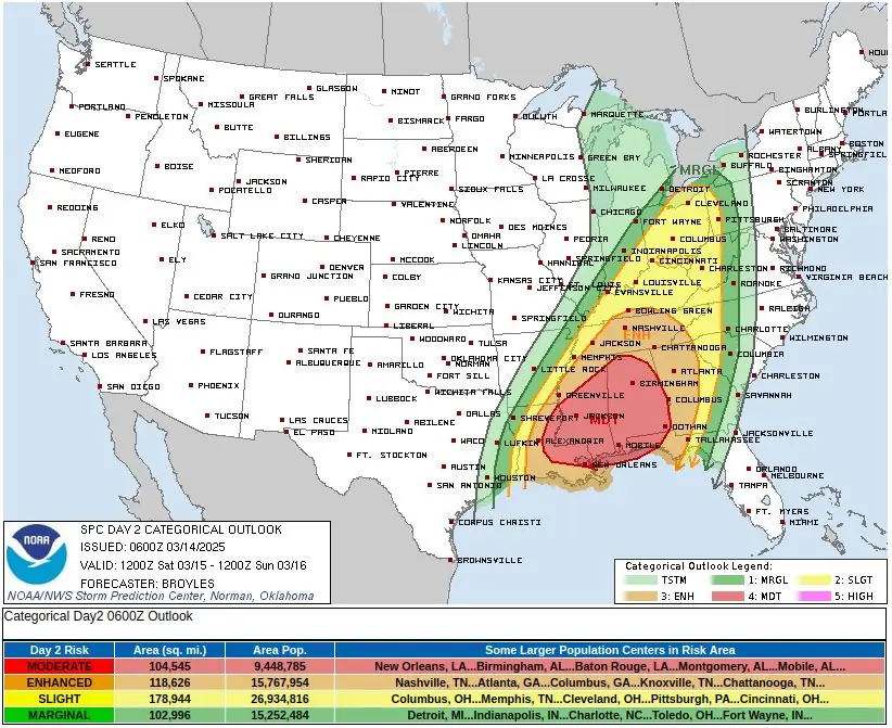
SPC issues level 4 risk of severe thunderstorms for parts of Tennessee, Mississippi, Alabama, and Louisiana from Saturday to Sunday morning
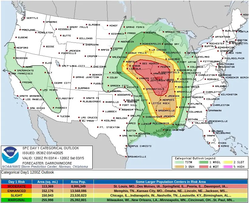
Severe storms will develop Friday, March 14, 2025, across the Central and Southern Plains into the Middle and Lower Mississippi Valley, where the SPC has issued a Moderate Risk (level 4/5) through Saturday morning. By Saturday, the threat shifts east, with a Moderate Risk in parts of the Tennessee Valley, Lower Mississippi Valley, and Southeast through Sunday morning. These storms may produce damaging winds exceeding 120 km/h (75 mph), hail larger than 5 cm (2 inches), and strong tornadoes rated EF-2 to EF-5.

Severe Thunderstorms Outlook - March 15, 2025. Credit: NWS, The Watchers
A severe weather outbreak is forecast across the Middle Mississippi Valley from Friday afternoon, March 14, through Friday night, bringing a risk of nocturnal tornadoes to the region.
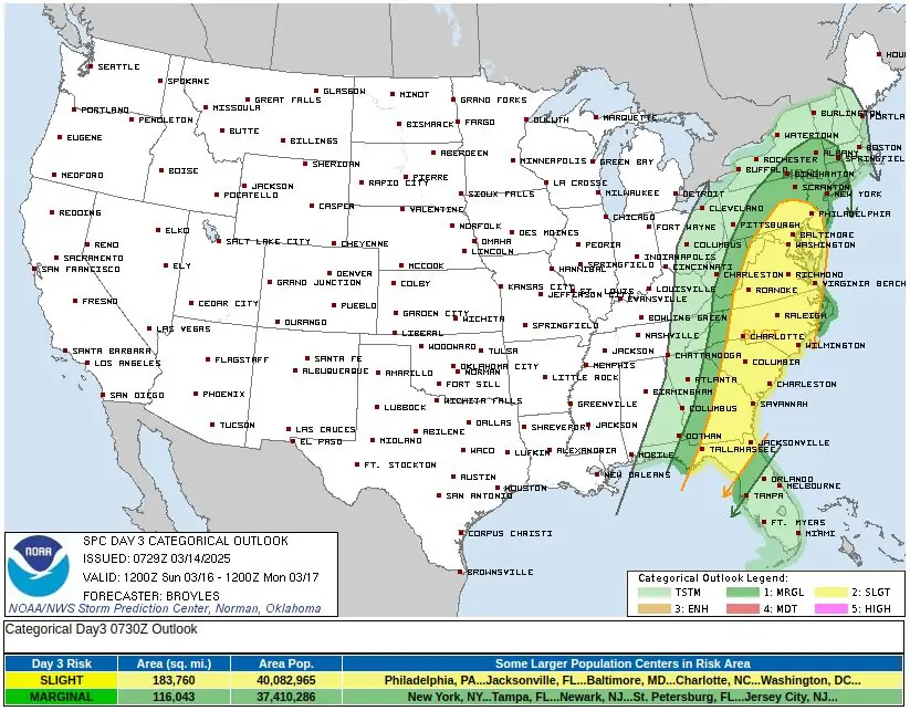
A cold front extending from the Central Plains to the Southern Plains will move eastward, reaching the Lower Great Lakes and the Central Gulf Coast by Sunday, March 16.
Friday: Severe storms develop in the Mississippi Valley
According to the National Weather Service (NWS), a line of severe thunderstorms will develop over Missouri on Friday afternoon, moving rapidly eastward into Illinois overnight.
The storms will bring frequent lightning, large hail, and damaging winds of 120 km/h (75 mph) or higher, along with a risk of tornadoes, some of which could be strong (EF-2 to EF-5).
The Storm Prediction Center (SPC) has issued a Moderate Risk (level 4/5) through Saturday morning, March 15, for parts of the Middle Mississippi Valley.
As the system progresses, severe weather will spread into the Middle and Lower Mississippi Valley and the Tennessee Valley overnight, with continued risks of tornadoes, intense wind gusts, and large hail.
Some of these storms will persist into the early morning hours of Saturday, increasing the risk of overnight tornadoes, which can be particularly dangerous due to reduced visibility and sleeping populations.
Saturday–Sunday: Major severe threat shifts east
On Saturday, March 15, as the cold front moves eastward, severe thunderstorms will expand into the Ohio Valley, Tennessee Valley, Lower Mississippi Valley, and the Southeast.
In response to this threat, the SPC has issued a Moderate Risk (level 4/5) from Saturday through Sunday morning for portions of these regions.
This severe weather outbreak is expected to bring damaging wind gusts over 120 km/h (75 mph), hail larger than 5 cm (2 inches), and strong tornadoes (EF-2 to EF-5 possible).
The threat of flash flooding will also increase as heavy rain spreads across the Ohio and Tennessee Valleys, the Lower Mississippi Valley, and the Southern Appalachians on Saturday.
In response, the Weather Prediction Center (WPC) has issued a Slight Risk (level 2/4) of excessive rainfall for these regions, warning of possible flash flooding in urban areas, roads, small streams, and low-lying locations.
While severe weather dominates the central and eastern U.S., the system will also produce heavy snowfall over the Upper Mississippi Valley on Saturday, affecting parts of Minnesota, Wisconsin, and Michigan. Rain will also spread across portions of the Upper Great Lakes, creating hazardous travel conditions.
Meanwhile, a separate storm system in the Eastern Pacific will push inland over the West Coast and the Rockies before dissipating on Saturday morning. This will bring coastal rain and high-elevation snow to parts of the Pacific Northwest and California, with heavy snowfall expected in the Sierra Nevada Mountains.
Another wave of upper-level energy will impact the Pacific Northwest on Saturday, bringing additional heavy snow to the Cascades and Northern Intermountain Region through the weekend.
References:
1 Short Range Forecast Discussion – NWS/SPC – March 14, 2025

I am an Assistant Editor and Severe Weather & Science Journalist at The Watchers, specializing in real-time severe weather coverage, geophysical event reporting, and research-driven scientific analysis. You can reach me at rishav(at)watchers(.)news.
Commenting rules and guidelines
We value the thoughts and opinions of our readers and welcome healthy discussions on our website. In order to maintain a respectful and positive community, we ask that all commenters follow these rules.