
Nocturnal tornado outbreak forecast for Mississippi River Valley
A significant tornado outbreak is expected Friday night across parts of Missouri, Illinois, Kentucky, Tennessee, and Mississippi. A deep low-pressure system will generate hurricane-force low-level winds, fueling multiple supercell thunderstorms capable of producing strong tornadoes. The highest risk will occur after sunset.

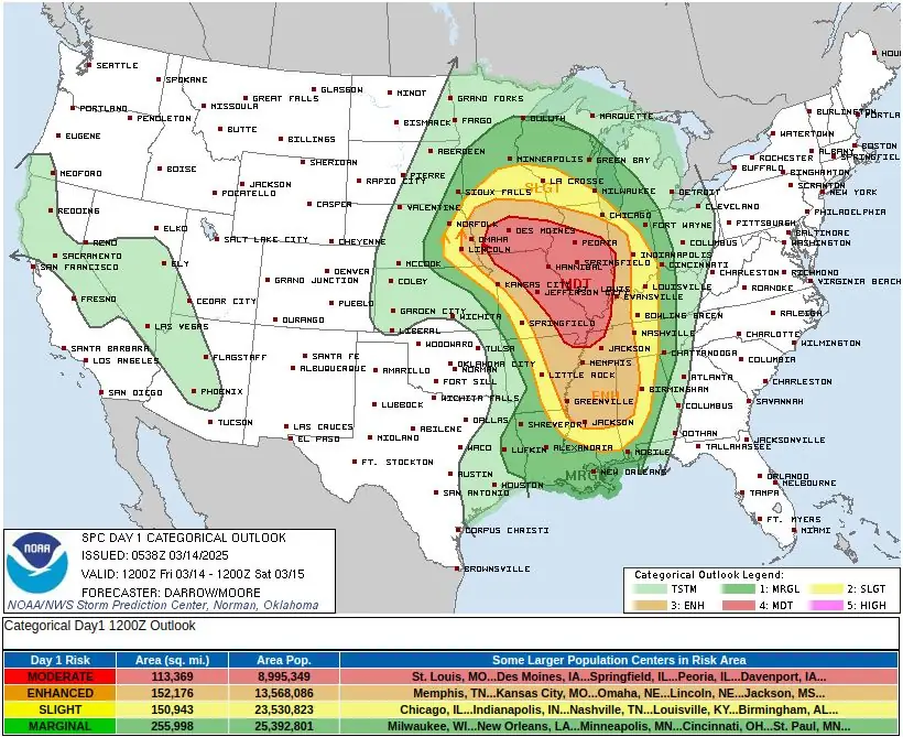
Severe Thunderstorms Outlook - March 14, 2025. Credit: NWS, The Watchers
- The Storm Prediction Center (SPC) has issued a Moderate Risk (level 4/5) of severe thunderstorms over parts of the Middle Mississippi Valley through Saturday morning.
- The hazards associated with these thunderstorms are frequent lightning, severe thunderstorm wind gusts, hail, and a few tornadoes.
- There is an additional threat of EF-2 to EF-5 tornadoes over parts of the Middle/Lower Mississippi Valley and Tennessee Valley.
- There is an increased threat of severe thunderstorm wind gusts of 120 km/h (75 mph) or greater and hail 5 cm (2 inches) or larger over the region.
A powerful surface low, forecast to reach pressures in the 970s hPa range, will move from the central Great Plains to the upper Midwest on Friday, March 14, 2025. This system will intensify the low-level jet, with wind speeds approaching hurricane force, drawing warm, moist air northward.
By sunset, dew points near 16°C (60°F) are expected as far north as St. Louis, creating an environment conducive to severe thunderstorms.
Multiple bands of supercells will develop from eastern Missouri into central and southern Illinois during the evening, progressing southward into Mississippi, western Kentucky, and western Tennessee by the middle of the night.
These storms will be capable of producing large, long-track tornadoes, particularly in areas where low-level shear is strongest.
Due to the nighttime timing of this outbreak, residents in the affected regions are urged to remain alert and have multiple ways to receive emergency alerts. Power outages and damaged communication networks could occur, making it critical to have a charged weather radio with alarms activated.
Be prepared for potential tornado warnings and have a safety plan in place before storms arrive. Those in the risk zone should review sheltering procedures and stay updated on weather developments throughout the night.
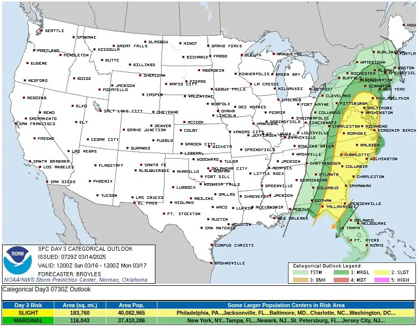
This will be the first day of a multi-day severe weather outbreak expected in the Mississippi Valley into the Lower Ohio Valley into Saturday, March 14, and through the Central Gulf states on Saturday.
The National Weather Service (NWS) Storm Prediction Center (SPC) has issued a Moderate Risk (level 4/5) of severe thunderstorms over parts of the Middle Mississippi Valley through Saturday morning, March 15.
The hazards associated with these thunderstorms are frequent lightning, severe thunderstorm wind gusts, hail, and a few tornadoes. There is an additional threat of EF-2 to EF-5 tornadoes over parts of the Middle/Lower Mississippi Valley and Tennessee Valley.
There is an increased threat of severe thunderstorm wind gusts of 120 km/h (75 mph) or greater and hail 5 cm (2 inches) or larger over the region.
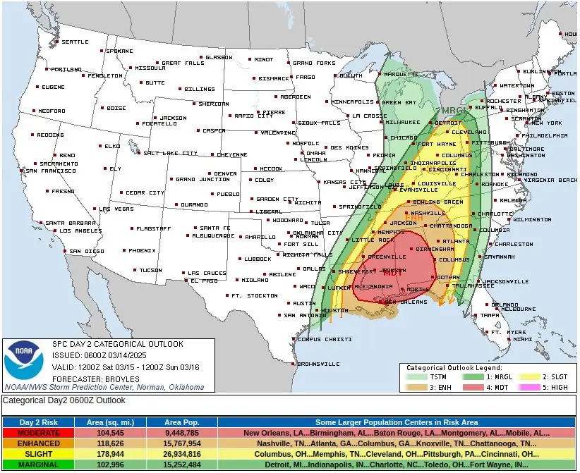
On Saturday, March 15, as the front moves eastward, showers and severe thunderstorms are expected to develop over parts of Ohio, Tennessee, and the Lower Mississippi Valleys, extending into the Southeast.
As a result, the SPC has issued a Moderate Risk (level 4/5) for severe thunderstorms over portions of the Tennessee and Lower Mississippi Valleys, as well as the Southeast, from Saturday through Sunday morning, March 16.
Hazards associated with these storms include frequent lightning, severe wind gusts, hail, and isolated tornadoes.
Additionally, there is a risk of EF-2 to EF-5 tornadoes, severe wind gusts of 120 km/h (75 mph) or greater, and hail 5 cm (2 inches) or larger over parts of the Middle and Lower Mississippi Valley, as well as the Tennessee Valley.
References:
1 Short Range Forecast Discussion – NWS/WPC – Issued at 04:04 EDT on Friday, March 14, 2025
I'm a dedicated researcher, journalist, and editor at The Watchers. With over 20 years of experience in the media industry, I specialize in hard science news, focusing on extreme weather, seismic and volcanic activity, space weather, and astronomy, including near-Earth objects and planetary defense strategies. You can reach me at teo /at/ watchers.news.
Commenting rules and guidelines
We value the thoughts and opinions of our readers and welcome healthy discussions on our website. In order to maintain a respectful and positive community, we ask that all commenters follow these rules.