
Historic fire-weather conditions forecast for southern Great Plains
Extremely critical fire weather conditions are forecast for Friday, March 14, 2025, across parts of the southern Plains and Midwest due to historically strong winds and low humidity. A wildfire outbreak is possible in the southern Plains, with fast-moving and uncontrollable fires likely. Wind gusts between 95–130 km/h (60–80 mph) may cause rapid fire spread and significant danger to affected areas.

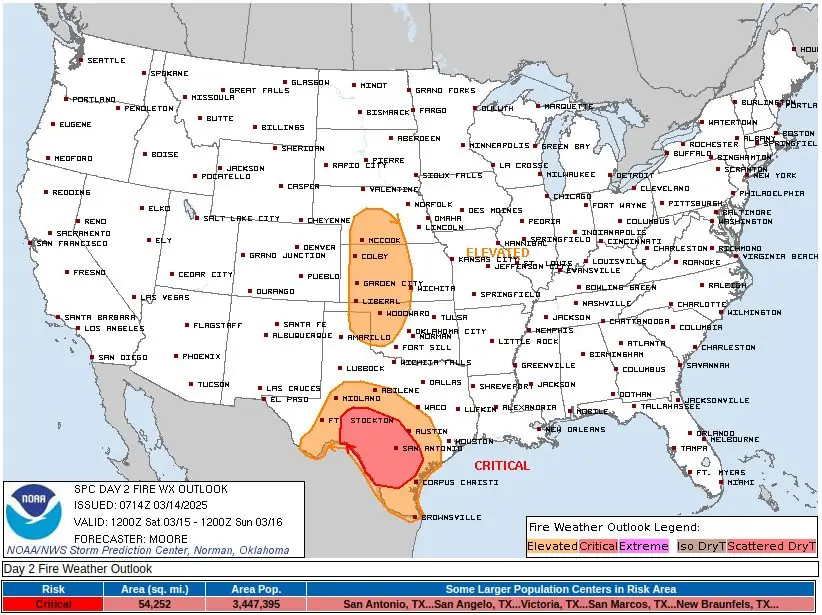
Fire Weather Outlook for March 14, 2025. Image credit: NWS, The Watchers
The National Weather Service (NWS) warns of potentially historic fire-weather conditions on Friday, March 14, in the southern Great Plains, with ‘historically strong winds,’ low relative humidity, and dry fuels likely to cause numerous large wildfires.
The combination of very low relative humidity and gusty winds of 95–130 km/h (60–80 mph) will create conditions conducive to large, fast-moving wildfires. These fires may become uncontrollable shortly after ignition, posing a serious threat to property, infrastructure, and safety.
Given the intensity of the forecasted wind speeds and dry conditions, officials warn that wildfires could spread rapidly, overwhelming suppression efforts.

Hazardous conditions are driven by a deepening low-pressure system over the central High Plains.
In 12 hours to 06:00 UTC (01:00 CDT) on March 14, pressure has dropped by approximately 15 hPa, strengthening low-level winds. Observations already show 92 km/h (57 mph) winds within the lowest kilometer of the atmosphere, with further intensification expected through Friday.
By early afternoon (LT), sustained winds of 48–64 km/h (30–40 mph) will extend from eastern New Mexico to northern Texas and Oklahoma, reaching southeastern Kansas by mid-afternoon. Gusts of 80–112 km/h (50–70 mph) will be widespread, with isolated gusts exceeding 128 km/h (80 mph) in western Texas.
Humidity levels will drop significantly due to dry air advection and deep boundary-layer mixing. Relative humidity (RH) is expected to range from 10–15% across the southern Plains, with some areas, particularly in northwest Texas, experiencing single-digit RH values. The combination of extremely strong winds, critically low humidity, and dry vegetation will lead to a high potential for uncontrollable wildfires.
In addition to wind-driven fire threats, dry thunderstorms are likely in parts of northeast Oklahoma, Kansas, and Missouri. These storms will move rapidly, with wind speeds of 92–111 km/h (57–69 mph), limiting rainfall and increasing the likelihood of dry lightning igniting new fires.
Across the Midwest, winds of 30–40 km/h (20–25 mph) will develop as the surface low intensifies. Although humidity levels will be higher (20–30%), minimal rainfall in recent days has dried fine fuels, increasing the risk of fire spread.
The conditions will ease up on Saturday, March 15. However, elevated and critical fire weather will persist in parts of Texas, especially around San Antonio. Elevated fire weather conditions will persist in north Texas and parts of Oklahoma and Kansas.
Authorities urge residents to take precautions, including avoiding outdoor burning and using extreme caution with any potential ignition sources. Emergency officials also advise staying alert for potential evacuation orders and closely monitoring local weather updates.
Residents in high-risk areas should have an emergency plan in place and be prepared to evacuate if necessary.
References:
1 Fire Weather Outlook for March 14, 2025 – NWS/SPC – Issued at 01:06 CDT on Friday, March 14, 2025
I'm a dedicated researcher, journalist, and editor at The Watchers. With over 20 years of experience in the media industry, I specialize in hard science news, focusing on extreme weather, seismic and volcanic activity, space weather, and astronomy, including near-Earth objects and planetary defense strategies. You can reach me at teo /at/ watchers.news.
Commenting rules and guidelines
We value the thoughts and opinions of our readers and welcome healthy discussions on our website. In order to maintain a respectful and positive community, we ask that all commenters follow these rules.