
Increased seismicity at Mount Adams volcano, U.S.
Six earthquakes were detected at Mount Adams in September 2024, the highest monthly total since monitoring began in 1982. Ranked as a high-threat volcano by the US Geological Survey due to its volcanic hazards and nearby communities, Mount Adams last erupted between 3 800 and 7 600 years ago. Lahars from landslides on its southwest side, occurring between 6 000 and 300 years ago, reached as far as Trout Lake, a community of 822 people located 22 km (13 miles) south of the volcano.

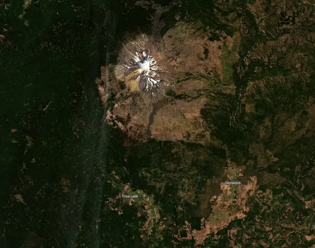
Satellite image of Mount Adams in Washington, U.S. acquired on October 3, 2024. Credit: Copernicus EU/Sentinel-2, The Watchers
- Six earthquakes were detected at Mount Adams in September 2024, marking the highest monthly total since monitoring began in 1982.
- The USGS national volcanic threat assessment ranks Mount Adams as a high-threat volcano, considering both volcanic hazards and community exposure.
- The last volcanic eruption at Mount Adams occurred between 3 800 and 7 600 years ago.
- About 6 000 and 300 years ago, lahars generated by landslides of weakened rock high on the southwest side of the volcano flowed as far as the Trout Lake area and beyond.
The U.S. Geological Survey’s (USGS) Cascades Volcano Observatory (CVO), along with the Pacific Northwest Seismic Network (PNSN), detected 6 earthquakes at Mount Adams in south-central Washington in September 2024. The earthquakes ranged between M0.9 and M2.0.
Typically, this volcano experiences one earthquake every 2 – 3 years.
The locations and depths are not well-constrained due to the sparse seismic network at Mount Adams, and smaller earthquakes have occurred that seismologists have been unable to locate. None of them was felt at the surface.
The earthquakes were detected by a PNSN-operated seismic station, ASR2, located approximately 11 km (7 miles) southwest of the volcano’s summit, along with other stations located further away.
This marks the most earthquakes recorded at Mount Adams in a single month since monitoring began in 1982. Monitoring capacities for the volcano are limited as only one seismic station is currently active near the volcano.
No detectable ground deformation at the volcano could be observed via satellite imagery. No information regarding gas emissions is available since Mount Adams has no gas sampling programs. Currently, the Aviation Color Code for the volcano is Green, and the Alert Level is Normal.
CVO and PNSN plan to set up a temporary seismic station in the area to better detect smaller earthquakes and determine their depth and location.

Mount Adams, located about 80 km (50 miles) west-southwest of Yakima, Washington, and 55 km (30 miles) north of the White Salmon-Hood River area along the Columbia River, is part of the north-south trending Mount Adams-King Mountain volcanic field.
This field includes more than 120 smaller volcanoes spread across several counties, including Skamania, Lewis, Klickitat, and Yakima, as well as parts of the Yakama Nation. Mount Adams is the second tallest volcano in Washington State and the largest active volcano in the state in both area and volume. Despite its size, its typical activity has been effusive, primarily producing lava flows rather than explosive eruptions.
In the last 12 000 years, Mount Adams has experienced four lava flows originating from the volcano’s apron and two from vents along its south ridge. These flows generally travel only a few kilometers from their source, and the last volcanic eruption occurred between 3 800 and 7 600 years ago.
The greatest threat to nearby communities is the potential for lahars, which are fast-moving flows of rock, ash, and ice that surge downstream like liquid concrete. These lahars could occur during both eruptive and non-eruptive periods, and have flowed as far as the Trout Lake area (22 km / 13 miles) about 6 000 and 300 years ago.
Smaller landslide-triggered avalanches of rock and snow have also occurred, most recently in 1987, although they did not travel more than a few kilometers.
The USGS national volcanic threat assessment ranks Mount Adams as a high-threat volcano. This ranking considers both the volcano’s hazards and the potential exposure of nearby communities — Trout Lake (population 822), located 22 km (13 miles) S of the volcano; Glenwood (population 220), located 25 km (15 miles) SSE of the volcano.
The volcano’s hazards are based on the recency and style of previous eruptions, while exposure factors take into account population density, aviation activity, and infrastructure near the volcano.
The USGS, through its Cascades Volcano Observatory, continues to improve monitoring efforts at Mount Adams and other high-threat volcanoes in the Cascade Range, as part of the National Volcano Early Warning System authorized in 2019.
References:
1 CASCADES VOLCANO OBSERVATORY INFORMATION STATEMENT – USGS – Released at 19:37 UTC on October 3, 2024

I am an Assistant Editor and Severe Weather & Science Journalist at The Watchers, specializing in real-time severe weather coverage, geophysical event reporting, and research-driven scientific analysis. You can reach me at rishav(at)watchers(.)news.
Commenting rules and guidelines
We value the thoughts and opinions of our readers and welcome healthy discussions on our website. In order to maintain a respectful and positive community, we ask that all commenters follow these rules.