
Kīlauea volcano alert level raised as magma intrusion continues, Hawaii
Magma intrusion began in Kīlauea’s Middle East Rift Zone on September 15, 2024, increasing the potential for an eruption in this region. As a result, the USGS Hawaiian Volcano Observatory raised the Volcano Alert Level from Advisory to Watch and the Aviation Color Code from Yellow to Orange on September 16.
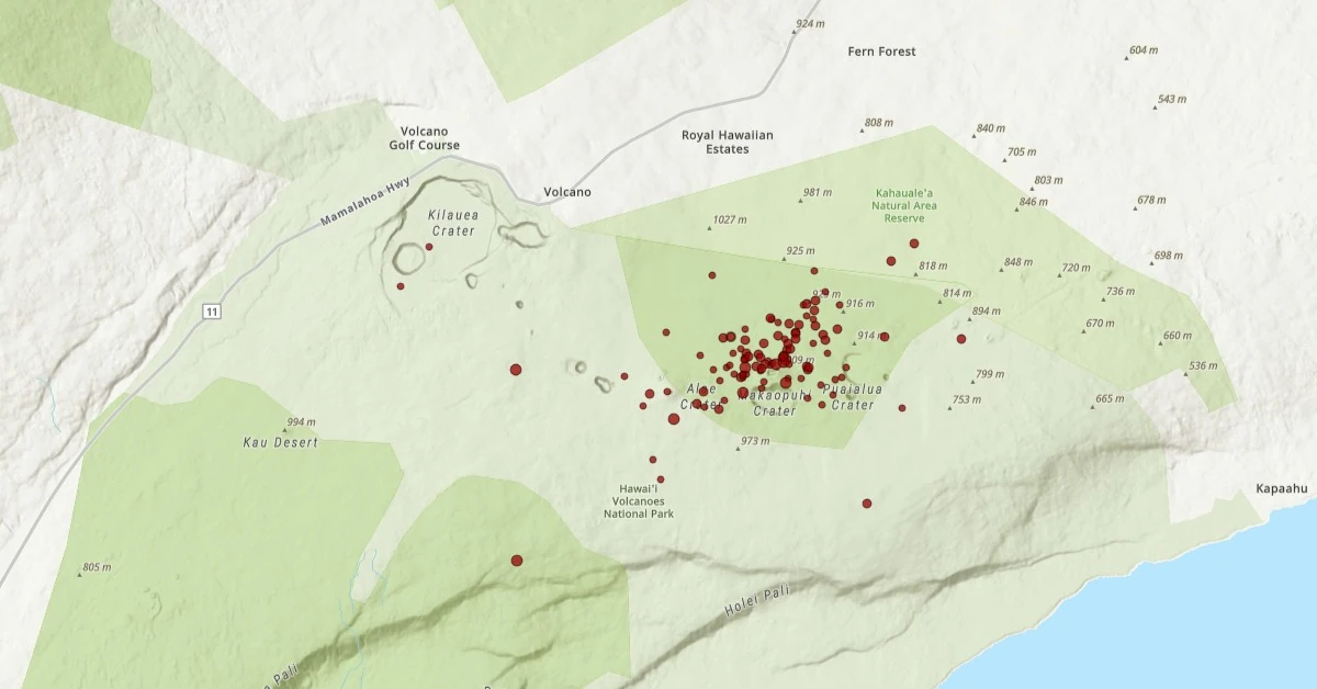
Featured image: 04 UTC on September 16, 2024. Credit: TW/SAM, ESRI. Data source: USGS
Magma movement beneath Kīlauea’s Middle East Rift Zone that started on September 15 has intensified, prompting officials to elevate the volcano’s alert status due to the increased risk of eruption.
The intrusion is occurring in a remote section of Kīlauea’s middle East Rift Zone within Hawaiʻi Volcanoes National Park. No significant changes have been observed in the lower East Rift Zone or the Southwest Rift Zone.
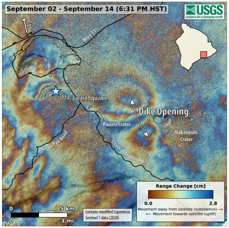
Intense localized earthquakes between Maunaulu and Makaopuhi Crater began around 02:00 UTC on September 15 (18:00 HST on September 14), accompanied by ground deformation indicative of underground crack expansion.
While earthquake activity has decreased in intensity, ground deformation data confirm that magma continues to migrate from summit storage chambers toward the area between Maunaulu and Makaopuhi Crater.
Between 07:00 UTC and 08:00 UTC on September 16, infrasound instruments detected strong signals characteristic of gas or steam venting. Additionally, seismometers in the Middle East Rift Zone are recording weak, sustained low-frequency tremors.
Due to increased gas emissions and seismic activity, the Hawaiʻi Volcanoes National Park has closed the Chain of Craters Road.
The USGS Hawaiian Volcano Observatory’s webcam network has not detected any eruptive activity, and GOES satellite data show no thermal anomalies at this time. Heavy rainfall in the area is currently complicating data interpretation.
In 2007, a similar magma intrusion in this region resulted in the eruption of a small lava pad approximately 0.2 ha (0.5 acres) in size. Under current conditions, a similarly small eruption could occur undetected.
Shallow magma movements and potential eruptions can cause minor to severe ground fractures and subsidence, altering the landscape. These ground cracks may continue to widen and shift as magma migration persists and may have unstable overhanging edges, posing risks to safety.
Additional hazards remain around the Kīlauea caldera due to the instability of the Halemaʻumaʻu crater walls, ground cracking, and rockfalls, which can be intensified by local earthquakes. This region has been closed to the public since early 2008 for safety reasons.
This area experienced numerous eruptions during the 1960s and 1970s, most lasting from less than one day up to two weeks. Extended eruptions occurred at Maunaulu between 1969–1971 and 1972–1974, and at Puʻuʻōʻō from 1983 to 2018. The most recent prolonged eruption near the Puʻuʻōʻō vent lasted 35 years.
References:
1 Volcanic Activity Notice for Kilauea – HVO/USGS – 10:23 UTC on September 16, 2024
I'm a dedicated researcher, journalist, and editor at The Watchers. With over 20 years of experience in the media industry, I specialize in hard science news, focusing on extreme weather, seismic and volcanic activity, space weather, and astronomy, including near-Earth objects and planetary defense strategies. You can reach me at teo /at/ watchers.news.
Commenting rules and guidelines
We value the thoughts and opinions of our readers and welcome healthy discussions on our website. In order to maintain a respectful and positive community, we ask that all commenters follow these rules.