
Increased earthquake activity near Makaopuhi Crater, Kilauea, Hawaii
Earthquake activity has increased in Kīlauea’s middle East Rift Zone, near Makaopuhi rater at around 02:00 UTC, on Sunday, September 15, 2024. At the same time, ground deformation patterns west (uprift) of Puʻuʻōʻō suggest that another intrusive event could be occurring in this region.

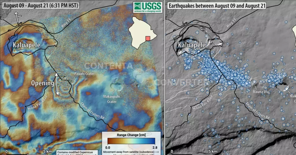
Image credit: TW/SAM, ESRI. Data source USGS
The Hawaiian Volcano Observatory is reporting increased earthquake activity in the region between Pauahi and Makaopuhi craters starting around 02:00 UTC on September 15.
Approximately 60 earthquakes were detected until 04:59 UTC, with increasing intensity concentrated near Makaopuhi Crater in the East Rift Zone. Ground deformation patterns west of Puʻuʻōʻō were detected around 04:00 UTC, suggesting that another underground intrusion, similar to the activity in July and August, could be occurring in the region.
At 02:45 UTC on September 14, an M4.3 earthquake was registered about 6 km (4 miles) SSW of Volcano at a depth of 0.3 km (0.2 miles) below sea level. The earthquake had no apparent impact on either Mauna Loa or Kīlauea volcanoes.
“The size, location, and character of this earthquake suggest that it is related to the ongoing pressurized magma storage system beneath Kīlauea’s summit area, which extends into the upper East Rift Zone, where intrusions of magma have recently occurred,” HVO said.

Several aftershocks were detected within the first 30 minutes after the earthquake, as is typical for an event of this size. Additional aftershocks are expected to be minor but may continue for days to weeks.
Currently, the volcano is not showing any signs of a potential eruption. The volcano’s Alert Level remains at Advisory, and the Aviation Color Code is Yellow. The activity is mostly concentrated around the upper to middle East Rift Zone.
Past eruptive activity in the upper-to-middle East Rift Zone has been primarily concentrated in the region between Hiiaka Crater and Maunaulu in Hawaii Volcanoes National Park.
Meanwhile, the rates of seismicity and ground deformation remain low beneath the lower East Rift Zone and the Southwest Rift Zone.
References:
1 HAWAIIAN VOLCANO OBSERVATORY STATUS REPORT – USGS – Released at 04:59 UTC, September 15, 2024

I am an Assistant Editor and Severe Weather & Science Journalist at The Watchers, specializing in real-time severe weather coverage, geophysical event reporting, and research-driven scientific analysis. You can reach me at rishav(at)watchers(.)news.
Commenting rules and guidelines
We value the thoughts and opinions of our readers and welcome healthy discussions on our website. In order to maintain a respectful and positive community, we ask that all commenters follow these rules.