
Tropical Storm “Ernesto” forms near Leeward Islands
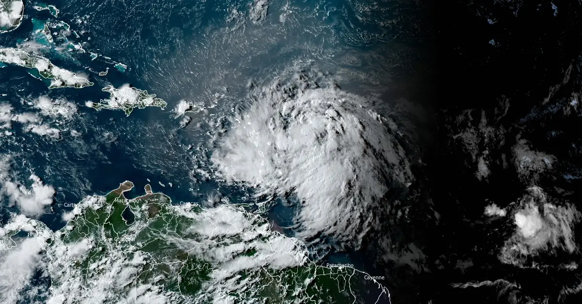
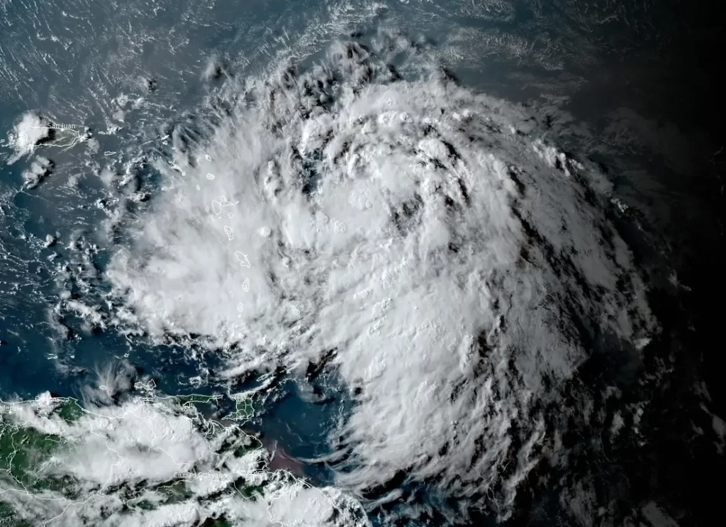
Featured image: Tropical Storm "Ernesto" at 21:00 UTC on August 12, 2024. Credit: NOAA/GOES-East, RAMMB/CIRA, The Watchers
Tropical Storm “Ernsesto” formed at 12:00 UTC on Monday, August 12, 2024, near the Caribbean Sea as the 5th named storm of the 2024 Atlantic hurricane season. The system is expected to bring tropical storm force winds and heavy rains to portions of the Leeward Islands beginning late tonight (LT).
- Ernesto is expected to bring tropical storm conditions to portions of the Leeward Islands late tonight and Tuesday, August 13, and to the Virgin Islands and Puerto Rico by late Tuesday. Tropical Storm Warnings are in effect for this entire area.
- Heavy rainfall may result in locally considerable flash flooding and mudslides in areas of the Leeward and Virgin Islands through Wednesday, and over Puerto Rico late Tuesday into Thursday.
- It is too soon to know what impacts Ernesto could bring to Bermuda late this week, and interests there should monitor the progress of this system.
At 21:00 UTC on August 12, the center of Tropical Storm “Ernesto” was located 475 km (295 miles) ESE of Antigua and 950 km (590 miles) ESE of San Juan, Puerto Rico, according to the National Hurricane Center (NHC). The system had maximum sustained winds of 65 km/h (40 mph) and was moving WNW at 44 km/h (298 mph). Its minimum central pressure was 1 009 hPa.
A westward to west-northwestward motion with some decrease in forward speed is expected during the next couple of days.
A Tropical Storm Warning is in effect for St. Kitts, Nevis, Montserrat, Antigua, Barbuda, Anguilla, Guadeloupe, St. Martin, St. Barthelemy, Sint Maarten, the British Virgin Islands, the U.S. Virgin Islands, Puerto Rico, Vieques, and Culebra.
Tropical storm conditions are expected in the warning area for the Leeward Islands beginning late tonight or early Tuesday, August 12. Tropical storm conditions are expected to start spreading over the Virgin Islands and Puerto Rico by Tuesday evening.
NHC is urging interests elsewhere in the northeastern Caribbean should monitor the progress of Ernesto.
On the forecast track, Ernesto is expected to move across portions of the Leeward Islands late tonight or Tuesday, and near or over the U.S. and British Virgin Islands and Puerto Rico by Tuesday evening. Ernesto is then forecast to turn northward over the western Atlantic.
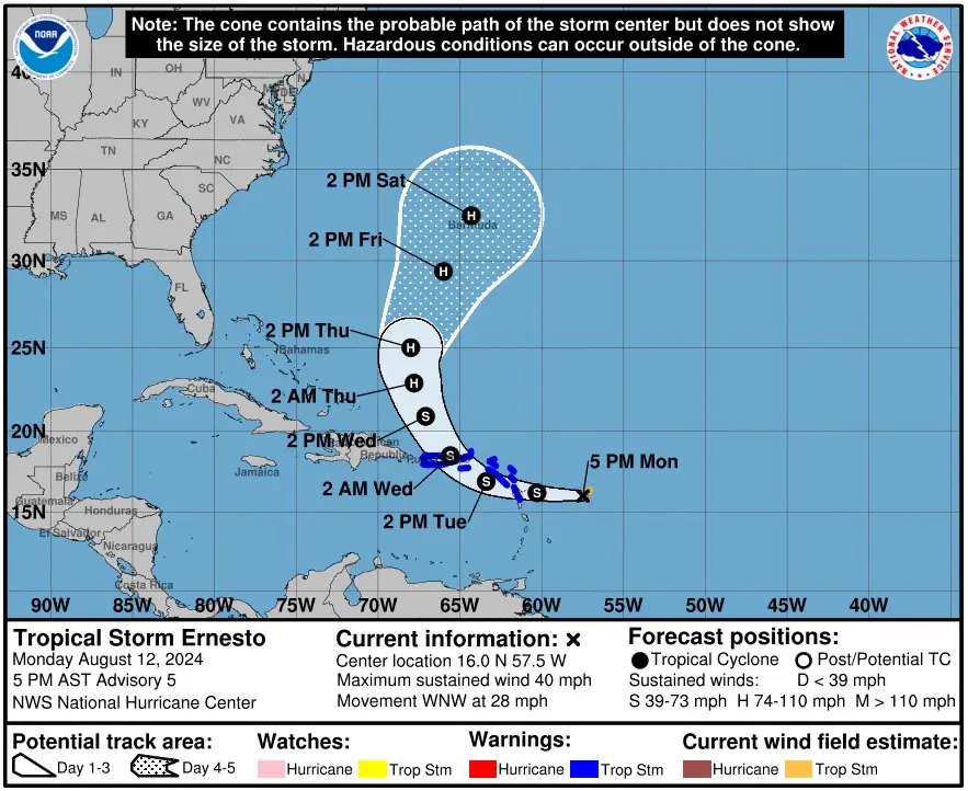
Gradual strengthening is expected during the next few days and Ernesto could strengthen into a hurricane by Thursday, August 15, and then turn toward Bermuda.
“Since Ernesto now has a center and a slightly improved circulation, strengthening seems likely,” NHC forecaster Cangialosi noted. “However, the rate of intensification will likely be slow during the next day or two due to the system’s broad structure and ragged convective pattern. More significant strengthening is forecast after Ernesto exits the Caribbean, when nearly all of the environmental conditions appear conducive.”
The system is expected to produce total rainfall accumulations of 100 – 150 mm (4 – 6 inches) over portions of the Leeward and Virgin Islands. For Puerto Rico, 75 – 150 mm (3 – 6 inches) of rainfall is expected, with maximum amounts reaching up to 250 mm (10 inches).
Elsewhere in the Caribbean, Ernesto is expected to produce the following rainfall accumulations through Friday morning: Windward Islands: 25 – 100 mm (1 – 4 inches), and Eastern Hispaniola: 50 – 100 mm (2 – 4 inches).
A storm surge will raise water levels by as much as 0.3 – 0.9 m (1 – 3 feet) above ground level for the eastern coast of Puerto Rico from San Juan to Guayama, including the islands of Culebra and Vieques, as well as in the U.S. Virgin Islands, including St. Thomas, St. John, and St. Croix.
A storm surge will raise water levels by as much as 0.3 – 0.9 m (1 – 3 feet) above normal tide levels in the British Virgin Islands. Near the coast, the surge will be accompanied by large and destructive waves.
Swells generated by Ernesto will likely begin affecting portions of the Leeward Islands beginning late tonight. These swells are likely to cause life-threatening surf and rip current conditions.
References:
1 Tropical Storm Ernesto Advisory Number 5 – NWS/NHC – Issued at 21:00 UTC on August 12, 2024
2 Tropical Storm Ernesto Discussion Number 5 – NWS/NHC – Issued at 21:00 UTC on August 12, 2024
I'm a dedicated researcher, journalist, and editor at The Watchers. With over 20 years of experience in the media industry, I specialize in hard science news, focusing on extreme weather, seismic and volcanic activity, space weather, and astronomy, including near-Earth objects and planetary defense strategies. You can reach me at teo /at/ watchers.news.
Commenting rules and guidelines
We value the thoughts and opinions of our readers and welcome healthy discussions on our website. In order to maintain a respectful and positive community, we ask that all commenters follow these rules.