
Red alerts issued for parts of Iceland as intense snow and blizzards hit the country
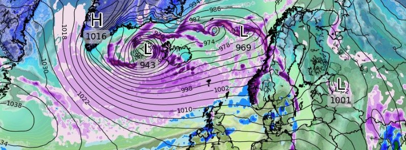
Image credit: WXCHARTS, GFS
Parts of Iceland were placed on Red Alert on Monday, February 7, 2022, due to a violent bomb cyclone affecting the country today. Wind gusts could reach up to 200 km/h (124 mph).
- A Red Alert for weather was issued for South Iceland and Faxafloi – Southwest Iceland.
- An Orange Alert is in effect for Breidafjordur – Westnorthwest Iceland, Westfjords, Northwest Iceland, Northeast Iceland, East Iceland, Eastfjords, Southeast Iceland and Central highlands – Uninhabited part of Iceland.
Faxaflói and South can expect winds with speeds between 85 – 110 km/h (55 – 70 mph), snow, and blowing snow. Sleet or rain are expected closest to shore. There is a high risk of damages and contractors are encouraged to secure building sites.
Reykjavik area can expect wind speeds between 45 – 70 km/h (30 – 45 mph), heavy showers of snow and poor traveling conditions. Wind gusts in snow showers could exceed 125 km/h (80 mph) locally. There is an increased risk of lightning.
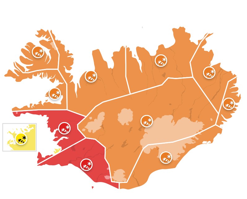
Weather alerts for Iceland as of 09:03 UTC on February 7, 2022. Credit: IMO
"The storm is now on a fast track to the northeast," the Icelandic Met Office said at 07:50 UTC. "The weather has been worst in the southwest corner of the country but is now moving to the northwest and then east over the country.
I'm a dedicated researcher, journalist, and editor at The Watchers. With over 20 years of experience in the media industry, I specialize in hard science news, focusing on extreme weather, seismic and volcanic activity, space weather, and astronomy, including near-Earth objects and planetary defense strategies. You can reach me at teo /at/ watchers.news.
Commenting rules and guidelines
We value the thoughts and opinions of our readers and welcome healthy discussions on our website. In order to maintain a respectful and positive community, we ask that all commenters follow these rules.