
Massive North Atlantic cyclone challenging all-time intensity records, Iceland issues red weather alerts
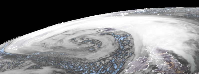
Featured image: Storm Dennis at 08:30 UTC on February 14, 2020. Credit: Meteosat-8
A powerful North Atlantic cyclone forced the Icelandic Met Office (IMO) to issue a red weather alert for southern Iceland, in effect through the first half on February 14, 2020. Violent and dangerous wind gusts may exceed 200 km/h (124 mph) in some areas. Residents are advised to secure their neighborhood, fasten loose items and show caution. Traveling is not advised while weather warnings are in effect. Damages due to flying debris are likely and construction workers are encouraged to secure construction sites.
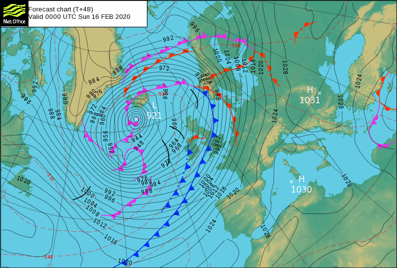
According to Capital Weather Gang's Andrew Freedman, this monster cyclone is forecast to become one of the 10 strongest storms on record for the region, possibly even number 1 or 2.
"At its peak, the storm may extend for 8 000 km (5 000 miles), with a cold front’s tentacles extending from near Florida all the way near the center of the beastly storm northwest of Scotland," Freedman said.
"Computer models show a rare scenario playing out, with the storm maxing out at an intensity of 915 hPa, which would be just 2 hPa shy of the all-time North Atlantic record, set by the Braer Storm of 1993. In general, the lower the air pressure, the stronger the storm. Such an air pressure reading would be more than five standard deviations from the norm, and would place the storm in the top 10 list of the strongest North Atlantic nontropical storms on record."
"This is the peak time of year for bomb cyclones in the North Atlantic, given the typical intensity of the jet stream and intense air mass differences that tend to move out over moisture-rich waters. What’s been especially noteworthy about the winter’s weather, however, is the frequency and intensity of the storms spawned in the North Atlantic. Very few of these storms typically see their minimum central air pressure drop to 930 hPa or lower; yet assuming Storm Dennis does so, this will have happened twice in the past 10 days. The storm east of Greenland, which helped propel Ciara into Europe, over the weekend accomplished this feat as well."
Reykjavik area is under red weather alert today (East strong gale, effective 08:00 – 12:00 LT). IMO said it expected extreme sustained wind speed 20 – 30 m/s (72 – 108 km/h / 45 – 68 mph) and violent gust in higher elevation suburbs and also on routes that lead out of the city, e.g. at Kjalarnes, Hellisheiði and on Reykjanesbraut. Snow and blowing snow are also expected.
Transport disturbances are expected during the weather and delay in air traffic.
Higher sea levels are anticipated due to storm surge with the possibility of small boats being damaged or detached from the dock.
South is also under red alert (Hurricane-force winds, effective 06:00 – 13:00 LT). Dangerous wind gusts, possibly exceeding 200 km/h (124 mph) are expected in the whole area as well as snow, blowing snow and poor visibility.
Traffic and service are temporarily shut down. No travel is advised and people should stay indoors.
Elevated sea level with high waves and dangerous conditions ad the coast.
Higher sea levels are anticipated due to storm surge with the possibility of small boats being damaged or detached from the dock.
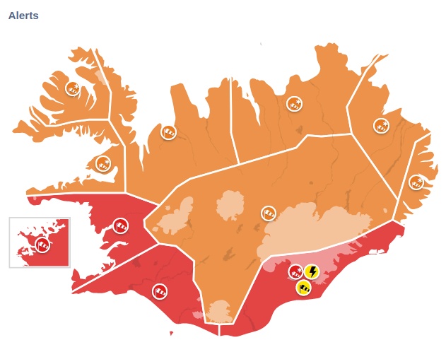
Image courtesy: IMO. Updated at 09:15 LT, February 14
Faxaflói (Red alert – East violent wind, possibly hurricane force, in effect 07:00 – 13:00 LT). Violent east winds expected with sustained wind speed 28 – 35 m/s (125 km/h / 78 mph) and violent and dangerous wind gust which may exceed 200 km/h (124 mph / 55 m/s) near mountains south of Borgarfjörður, but somewhat calmer winds in the north part of the forecasting region. Also, snow and blowing snow expected with very poor visibility.
Transport disturbances are expected. Higher sea levels are anticipated due to storm surge.
Risk of damages due to flying debris can be expected and people are advised to secure their surroundings, fasten loose items, and show caution. Traveling is not advised while the weather warning is in effect.
South East (Red alert – Hurricane-force winds and blizzard conditions, effective 07:00 – 12:00 LT). Sustained wind speed of 28 – 35 m/s (125 km/h / 78 mph) is expected. Dangerous wind gusts, possibly exceeding 200 km/h (124 mph) in the whole area. Snow and blowing snow and poor visibility. Traffic and service temporarily shut down. No travel is advised and people should stay indoors.
Elevated sea level with high waves and dangerous conditions ad the coast. Damages due to flying debris are likely and construction workers are encouraged to secure construction sites. Higher sea levels are anticipated due to storm surge with the possibility of small boats being damaged or detached from the dock.
People are advised to secure their neighborhood, fasten loose items and show caution. Traveling is not advised while the weather warning is in effect.
The rest of the country is under an orange alert through midnight, February 16.
I'm a dedicated researcher, journalist, and editor at The Watchers. With over 20 years of experience in the media industry, I specialize in hard science news, focusing on extreme weather, seismic and volcanic activity, space weather, and astronomy, including near-Earth objects and planetary defense strategies. You can reach me at teo /at/ watchers.news.
Commenting rules and guidelines
We value the thoughts and opinions of our readers and welcome healthy discussions on our website. In order to maintain a respectful and positive community, we ask that all commenters follow these rules.