
Eruption started north of Grindavík, lava enters city limits, Iceland

Image credit: IMO
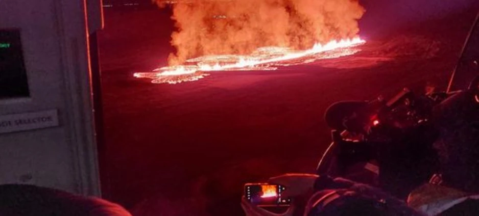
Another eruption began south-southeast of Hagafell, Reykjanes Peninsula, Iceland at 07:57 UTC on January 14, 2024. The latest images show the lava flowing toward the town of Grindavik. The perimeter was about 450 m (1 470 feet) from the northernmost houses in the town around 08:40 UTC.
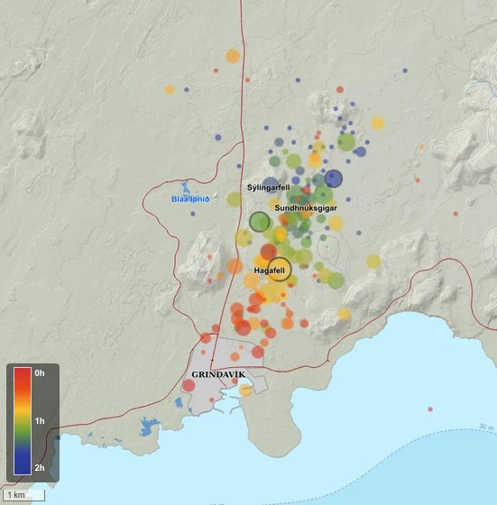
According to the Icelandic Met Office (IMO), an intense series of earthquakes began at the Sundhnúksgígar crater row at around 03:00 UTC today, with more than 200 earthquakes over the next 3 hours.
The largest recorded earthquake was M3.5 at Hagafell at 04:07 UTC.
BREAKING: A new volcanic fissure has opened up on Iceland's Reykjanes Peninsula just a few minutes ago. More details to come. pic.twitter.com/4yPZ98oQs5
— Nahel Belgherze (@WxNB_) January 14, 2024
CI RISIAMO! Poco meno di mezz'ora fa una nuova eruzione vulcanica è iniziata circa 1,5/2 km a nord di #Grindavík, in Islanda. La città sarebbe dovuta essere evacuata domani mattina per via dell'apertura di nuove crepe. Si salverà anche questa volta? Stay tuned! pic.twitter.com/jHIChpdzYD
— Il Mondo dei Terremoti (@mondoterremoti) January 14, 2024
Approximately 45 minutes after the start of the eruption, images from the Coast Guard’s surveillance flight showed a crack had opened on both sides of the defenses that have begun to be built north of Grindavík.
Judging by the pictures, lava is now flowing towards Grindavík. Based on measurements from the Coast Guard’s helicopter, the perimeter is now about 450 m (1 470 feet) from the northernmost houses in the town.

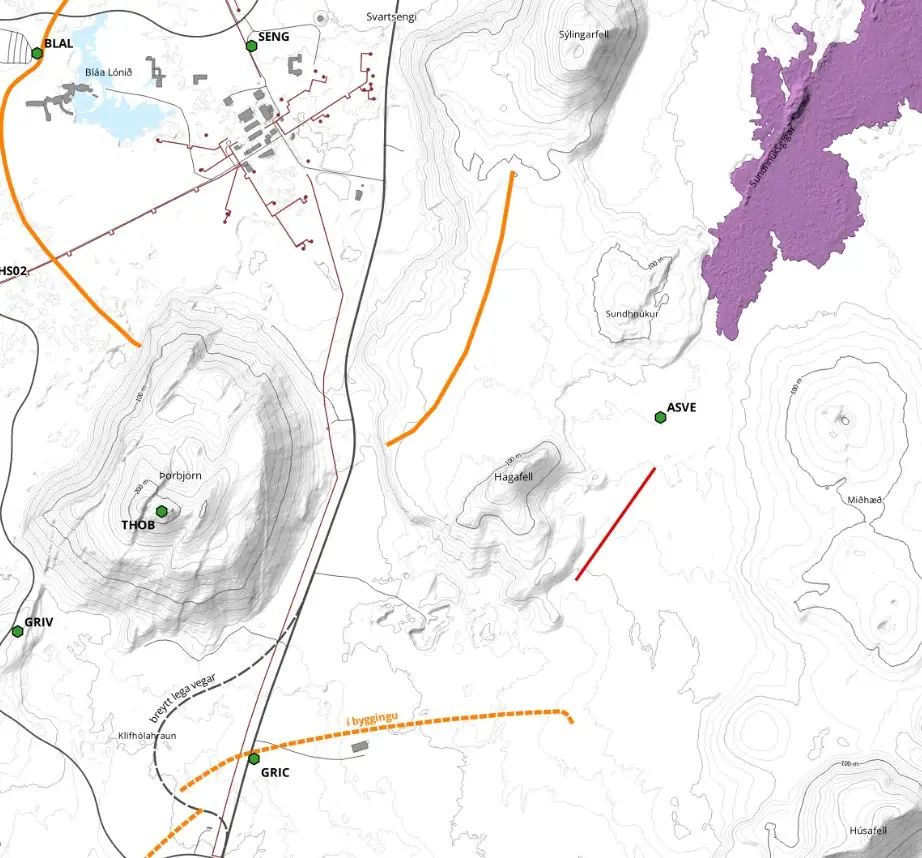
A red line on the map below shows the approximate location of the eruption:
Live view of the eruption:
Just before the eruption started, the Norwegian Meteorological Agency updated the hazard assessment map in light of the interpretation of the latest data.
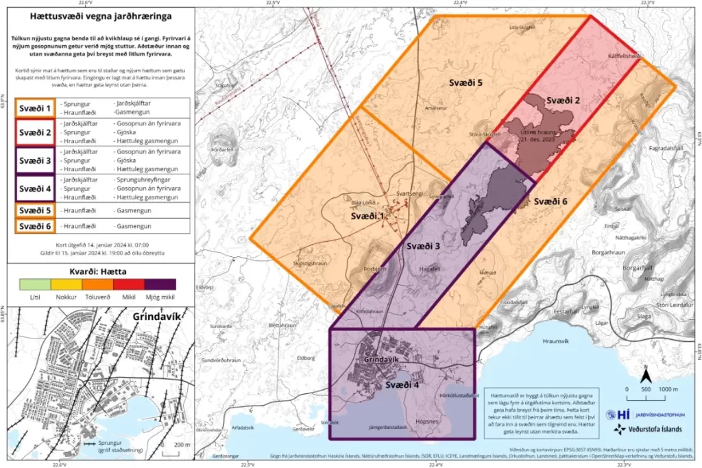
Both real-time GPS measurements and borehole pressure readings (from HS Orka) showed major changes since the onset of earthquake activity. In addition, seismicity moved toward the town of Grindavik.
The previous eruption in this region started on December 18, 2023, after months of intense seismicity and ground uplift, and ended on December 21.
Updates
15:30 UTC
The eruption near Hagafell-Grindavík has maintained the same strength for the past hour or so, IMO reported at 15:30 UTC.
Seismic measurements show that at the beginning of the unrest this morning, the magma-filled dike intrusion initially moved from the SE edge of Stóra-Skógfell and then continued southwest to the southern end of Grindavík.
At 05:30 UTC seismicity had reached the northern end of Grindavík and both seismicity and deformation measurements indicate the dike has since propagated beneath Grindavík town.
A new eruptive fissure opened at 12:10 UTC, just north of the town. Lava flows extruded from this fissure have now entered the town.
Due to the dike propagation, existing faults and fractures were reactivated and likely new fractures formed within Grindavík.
An eruption has started near Hagafell-Grindavík at 7:57 UTC. Then a new eruptive fissure opened at 12:10, just north of the town. Lava flows extruded from this fissure have now entered the town. https://t.co/9vYBBjNcX9 pic.twitter.com/Mdqh6C6CJ9
— Veðurstofa Íslands / Icelandic Met Office (@Vedurstofan) January 14, 2024
We are watching a disaster unfolding in real-time as lava from newly opened volcanic fissure is now entering Grindavík, engulfing first houses in the northern part of the town. pic.twitter.com/pfSQrS8uI5
— Nahel Belgherze (@WxNB_) January 14, 2024
Nýjasta grafíkin okkar sem sýnir gossprungurnar, varnargarðana og hraunbreiðuna. Eins og má sjá hafa varnargarðarnir sannað gildi sitt með því að leiða hraunflæði úr nyrðri sprungu frá bænum. pic.twitter.com/ZL3KfE6YjV
— Fréttastofa RÚV (@RUVfrettir) January 14, 2024
20:03 UTC
Two fissures are still erupting just north of Grindavík, the larger one is at Hagafell and the smaller one is right at the town’s border, IMO reported at 18:45 UTC, adding that lava flows from both fissures.
The smaller fissure, about 100 m (328 feet) long, which opened around 12:00 UTC, is just about 200 m (656 feet) from the Efrahópi neighborhood in Grindavík.
Lava flows from it into the city limits and causes considerable damage there.
I am devastated by todays event. I considered not posting images that show terrible tragedy to people’s homes. I want to make it clear that if there are any news outlets out there that need free content to raise awareness, let me know, nobody should make money on this! pic.twitter.com/CaNih72v6Z
— Bjorn Steinbekk (@BSteinbekk) January 14, 2024
The northern and larger fissure that opened at 07:57 UTC is about 900 m (2 950 feet) long and lava flows from it mainly to the west. It is mostly to the north of the fortifications that have recently been under construction. They direct the lava flow to the west and the lava tongue has reached well over Grindavíkurveg and from there on to the southwest.
A small part of the eruption is inside the dike, and the lava spread has been slowly expanding since this morning.
The speed of lava flow is not high, but is highest in the middle of the lava tubes. The amount of magma flowing out of the fissures, the speed of the lava flow and the size of the lava will be better assessed tomorrow.
Along with the formation of the magma tunnel to the southwest this morning towards and probably under Grindavík, there was a large deformation in the area of the eruption centers on new fissures and on older fissures that formed on November 10.
When the magma tunnel formed last night, there was an extremely rapid deformation. After the second fissure opened, deformation decreased significantly and almost stopped as the day progressed, especially at Hagafell and north of it. Deformation is still measured within Grindavík, but it is decreasing. Decreasing deformation is considered to be a sign that magmatic pressure is reaching equilibrium. However, it is not excluded that more eruptions will form.
Pollution from the eruption is spreading to the south and southwest.
The Civil Defense has called for an information meeting at the Rescue Center in Skógarhlíð tonight at 19:00 UTC. At the meeting chaired by Víðir Reynisson, the director of Public Safety, the events of the day will be reviewed. Prime Minister Katrín Jakobsdóttir and Benedikt Halldórsson, head of the Earthquakes Program at the Icelandic Meteorological Office, will also be at the meeting.
References:
1 Eldgos hafið – IMO – January 14, 2024
I'm a dedicated researcher, journalist, and editor at The Watchers. With over 20 years of experience in the media industry, I specialize in hard science news, focusing on extreme weather, seismic and volcanic activity, space weather, and astronomy, including near-Earth objects and planetary defense strategies. You can reach me at teo /at/ watchers.news.
I understand the impulse but “defenses” against a volcanic eruption and the flow of lava? Waste of time and resources. Case in point: the Big Island of Hawaii and its recent eruption/flow of lava. Remove as many possessions as possible and evacuate.
According to other reports Grindavík was sucessfully evacuated before lava burned down any houses.