
Tropical Storm “Isaias” impacts the Caribbean on its way toward Florida, U.S.
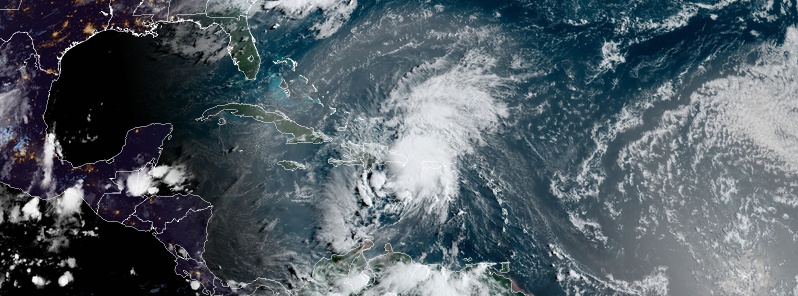
Featured image: Tropical Storm "Isaias" at 11:20 UTC on July 30, 2020. Credit: NOAA/GOES-East, RAMMB/CIRA
Tropical Storm "Isaias" formed at 03:00 UTC on July 30, 2020, as the 9th named storm of the 2020 Atlantic hurricane season. Isaias continued record early storm formations in the basin and is now the earliest 9th Atlantic named storm formation on record. The previous record was held by Irene which formed on August 8, 2005. According to Dr. Philip Klotzbach, Isaias is the 5th Atlantic named storm formation in July 2020, tying it with 2005 for the most Atlantic named storm formations on record (since 1851) during July.
NHC key messages:
- Isaias will produce heavy rains and potentially life-threatening flash flooding and mudslides across the Virgin Islands, Puerto Rico, the Dominican Republic, northern Haiti, and over the Bahamas, NHC warns.
- Tropical storm conditions are likely across portions of the Virgin Islands, and Puerto Rico through this morning (LT, July 30) and will spread westward to portions of the Dominican Republic, Haiti, and the Turks and Caicos and the Bahamas later today and Friday. Tropical Storm Warnings are in effect for these areas. Do not focus on the details of the track forecast, as rainfall and wind hazards will extend far from the center of the system.
- While this system could bring some rainfall and wind impacts to portions of Cuba and Florida later this week and this weekend, it is too soon to determine the location or magnitude of those impacts. Interests there should monitor the progress of this system and updates to the forecast over the next couple of days.
Heavy rainfall and gusty winds started spreading over the Lesser Antilles on July 28, while Isaias was still a disturbance. As it moved further WNW, bad weather spread to the U.S. and British Virgin Islands, Puerto Rico and the Dominican Republic.
Widespread flooding, landslides and power outages affected Puerto Rico early Thursday morning, July 29. According to the AP, Puerto Rico's southern region — still shaken by intense earthquake swarm — was hit especially hard. Isaias brought maximum sustained winds of 96 km/h (60 mph) to the region, downing trees and flooding neighborhoods damaged by earthquakes.
Reports coming from other parts of Puerto Rico early Thursday morning mention minor damage and power outages.
The island is still recovering from the widespread destruction caused by the passage of powerful Category 4 Hurricane "Maria" in September 2017. It was Puerto Ricos first Category 4 hurricane impact since 1932.
Tropical Storm "Isaias" at 11:20 UTC on July 30, 2020. Credit: NOAA/GOES-East, RAMMB/CIRA
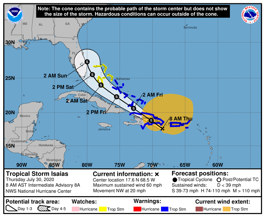
At 09:00 UTC on July 30 (05:00 AST), the center of Tropical Storm "Isaias" was located 165 km (100 miles) WSW of Ponce, Puerto Rico and 255 km (160 miles) SE of Santo Domingo, Dominican Republic.
The storm had maximum sustained winds of 95 km/h (60 mph) and was moving NW at 33 km/h (21 mph). Its minimum central pressure was 1 003 hPa.
Tropical-storm-force winds extended outward up to 665 km (415 miles) from the center.
A Tropical Storm Warning is in effect for:
– Puerto Rico, Vieques, Culebra
– U.S. Virgin Islands
– British Virgin Islands
– Dominican Republic entire southern and northern coastlines
– North coast of Haiti from Le Mole St Nicholas eastward to the northern border with the Dominican Republic
– Turks and Caicos Islands
– Southeastern Bahamas including the Acklins, Crooked Island, Long Cay, the Inaguas, Mayaguana, and the Ragged Islands
– Central Bahamas, including Cat Island, the Exumas, Long Island, Rum Cay, and San Salvador
A Tropical Storm Watch is in effect for:
– Northwestern Bahamas including Andros Island, New Providence, Eleuthera, Abacos Islands, Berry Islands, Grand Bahamas Island, and Bimini
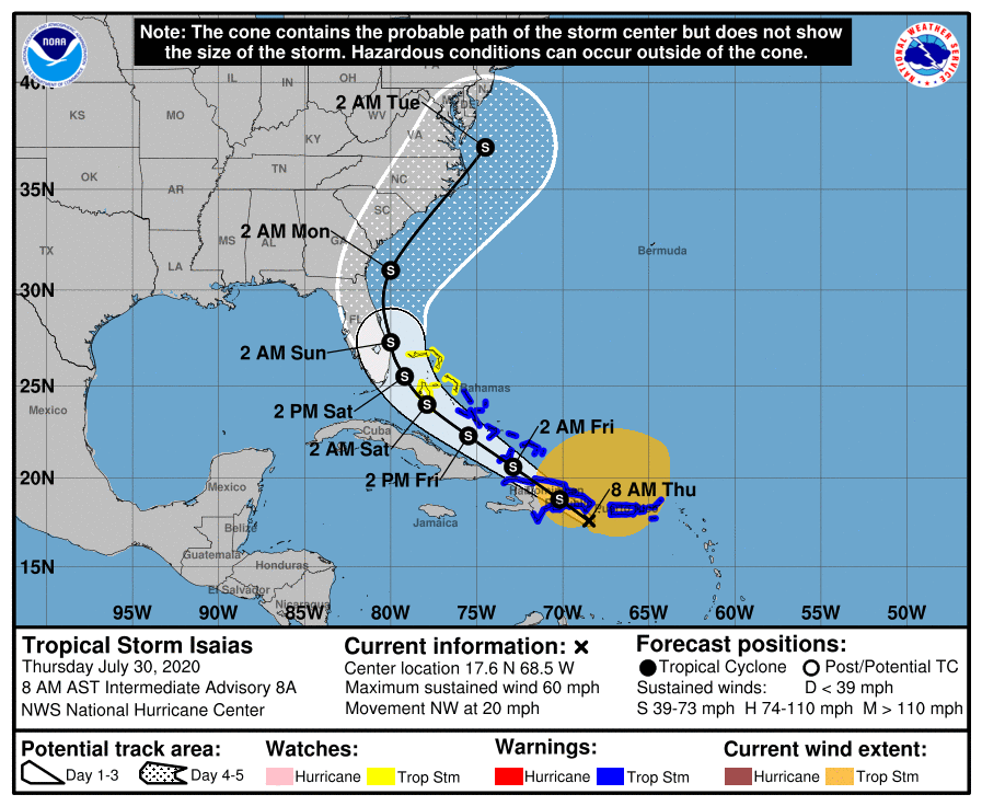
A west-northwestward to northwestward motion with some decrease in forward speed is expected over the next couple of days, NHC said.
On the forecast track, the center of Isaias will move over Hispaniola late today and near the southeastern Bahamas by early Friday, July 31. Little change in strength is anticipated until landfall in Dominican Republic later today, with re-strengthening forecast on Friday and Saturday.
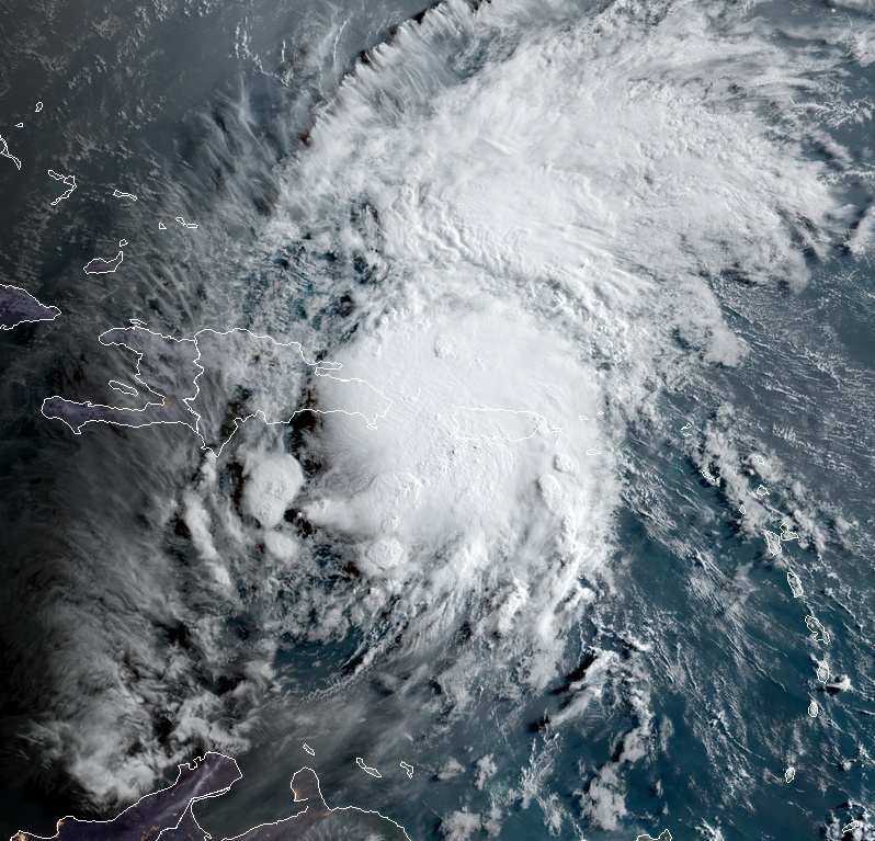
Tropical Storm "Isaias" at 12:00 UTC on July 30, 2020. Credit: NOAA/GOES-East, RAMMB/CIRA
"Isaias is sending some mixed signals tonight," NWS forecasters Blake and Cangialosi noted. "The 1-min rapid scan data from GOES-16 indicates that the low-level center is likely displaced west of a very intense burst of deep convection on the northeastern side of the circulation. However, the satellite data also shows increased banding features overnight and a more organized central cloud pattern, with recent hints that perhaps a low-level center is trying to re-form closer to the convection."
Model forecasts are showing a complex evolution of the tropical cyclone during the next day or two. There is a good agreement that Isaias will move across Hispaniola later today, and its low-level center will likely become disorganized over the high terrain. However, the strong burst of convection currently near Puerto Rico is associated with a mid-level circulation, which should pass along the north coast of Hispaniola later today.
Most of the model guidances suggest that this feature will cause the re-development of a surface center over the northern part of the broader system while the mid-level circulation moves close to the southeastern Bahamas.
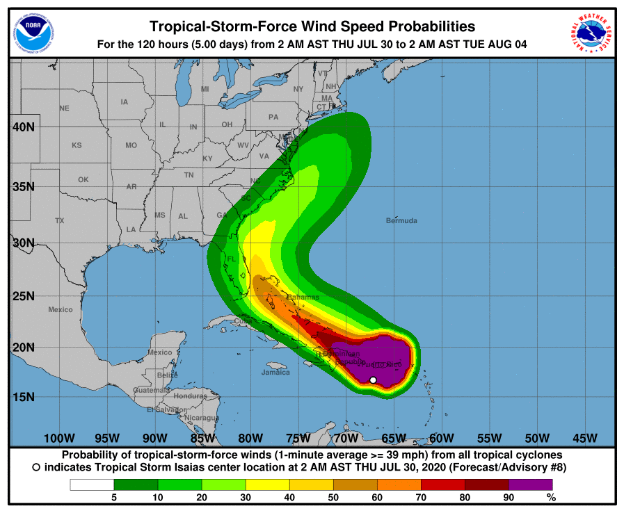
Afterward, the cyclone would then move northwestward until the weekend and gradually turn northward and northeastward close to the U.S. East Coast into early next week ahead of a mid-latitude trough.
"It should be noted that further adjustments to the forecast tracks are possible, especially after Isaias moves north of Hispaniola," NWS said.
"The intensity forecast is quite tricky. In the short term, Isaias is expected to move across Hispaniola, as the storm's interaction with the mountainous island should cause some weakening and disruption to the circulation. However, as mentioned before, the models suggest that a new center could form, and the environmental conditions would support gradual intensification. The intensity models have been trending higher, and the official forecast is nudged upward accordingly, now showing a peak intensity of 60 knots (111 km/h / 70 mph) when the storm is near the coast of Florida and the Southeast U.S. Coast.
"It should be noted that there are models that show hurricane strength near the U.S. but, given the large amount of uncertainty, it is preferred to stay on the conservative side for now. We should have a better idea of how strong Isaias will become near the U.S. after reconnaissance aircraft sample the storm and after it passes Hispaniola later today."
Tropical storm conditions will continue across portions of the Leeward Islands, the U.S. and British Virgin Islands and Puerto Rico overnight, NHC forecaster Blake noted.
These conditions are forecast to reach portions of the Dominican Republic and Haiti within the warning area by this morning, and the southeastern Bahamas and Turks and Caicos this afternoon (LT).
Tropical storm conditions are expected in the Central Bahamas beginning Friday morning and are possible in the northwestern Bahamas beginning late Friday.
Isaias is expected to produce the following rain accumulations:
British and U.S. Virgin Islands and Turks and Caicos: 75 – 150 mm (3 to 6 inches).
Puerto Rico and northern Haiti: 75 – 150 mm (3 to 6 inches), with isolated maximum totals of 205 mm (8 inches).
Dominican Republic: 102 – 205 (4 to 8 inches), with isolated maximum totals of 255 mm (10 inches).
Bahamas: 102 – 205 (4 to 8 inches).
Cuba: 50 – 100 mm (2 to 4 inches), with isolated maximum totals of 150 mm (6 inches).
These rainfall amounts will lead to life-threatening flash flooding and mudslides, as well as potential riverine flooding beginning today. Urban and small stream flooding is expected for the U.S. Virgin Islands, eastern Puerto Rico, and Hispaniola.
Swells generated by Isaias will be affecting portions of the Leeward Islands, the Virgin Islands, and Puerto Rico today. These swells are forecast to reach the north coast of the Dominican Republic, the Turks and Caicos Islands and the southeastern Bahamas this morning. They are likely to cause life-threatening surf and rip current conditions.
I'm a dedicated researcher, journalist, and editor at The Watchers. With over 20 years of experience in the media industry, I specialize in hard science news, focusing on extreme weather, seismic and volcanic activity, space weather, and astronomy, including near-Earth objects and planetary defense strategies. You can reach me at teo /at/ watchers.news.
Commenting rules and guidelines
We value the thoughts and opinions of our readers and welcome healthy discussions on our website. In order to maintain a respectful and positive community, we ask that all commenters follow these rules.