
One dead in Haiti as Tropical Storm Melissa brings severe weather across the Caribbean
At least one person has been reported dead in Haiti as Tropical Storm Melissa continues to bring severe weather across the Caribbean. The system is forecast to reach hurricane strength by Saturday, October 25, 2025. The storm threatens Haiti, Jamaica, and the Dominican Republic with heavy rainfall and possible hurricane-force winds later this weekend.
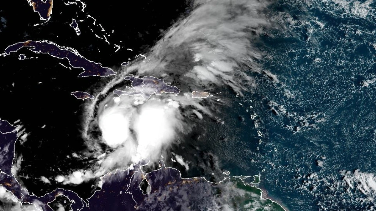
Satellite image of Tropical Storm Melissa at 11:00 UTC on October 24, 2025. Credit NOAA/GOES-19, RAMMB/CIRA, The Watchers
An elderly man was reported dead after winds caused by Tropical Storm Melissa downed a tree in the coastal town of Marigot in southern Haiti on Thursday, October 23. Five others were injured in flooding in the central Artibonite area, according to the Civil Protection Agency.
The United Nations announced on Thursday that it was preparing more than 100 emergency shelters in Haiti’s southern region.
Severe flooding triggered by heavy rain has already been affecting the Dominican Republic. Flooding caused by the storm knocked out dozens of water supply systems in the Dominican Republic, affecting more than half a million customers. It also downed trees and traffic lights and produced several small landslides.
All public schools across the Dominican Republic are closed on Friday, October 24, as well as government offices in 12 provinces under alert.
Inundaciones en el kilómetro 12 de la carretera Sánchez, santo Domingo.
— Edward López (@Edward_Caballon) October 24, 2025
Tormenta tropical Melissa. pic.twitter.com/MfJVOBbzjC
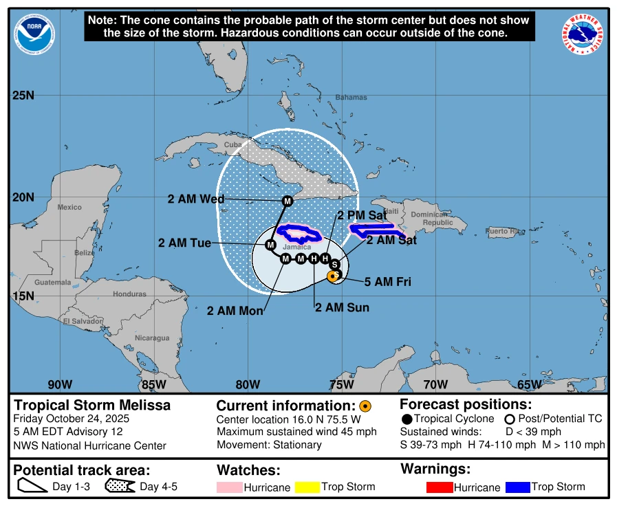
At 09:00 UTC on October 24, Melissa was located about 260 km (165 miles) south-southeast of Kingston, Jamaica, and about 445 km (275 miles) south-west of Port-au-Prince, Haiti.
Maximum sustained winds reached 75 km/h (45 mph), and the system was nearly stationary. It had an estimated minimum central pressure of 1 001 hPa.
The stalling and slow movement of Melissa is forecast to start a multi-day rain event across the Caribbean. Flash floods and landslides are especially likely in Jamaica and Haiti as the storm surge continues to increase.
Heavy rainfall of 200–360 mm (8–14 inches) is forecast for southern Haiti and the Dominican Republic through Sunday, October 26. 120–250 mm (5–10 inches) of rainfall is forecast for eastern Jamaica during the same period. Meanwhile, 50–100 mm (2–4 inches) of rainfall is forecast for northern Hispaniola and western Jamaica.
According to the National Hurricane Center (NHC), the system is forecast to rapidly intensify over the next 24 hours, potentially reaching hurricane strength within 36 hours from 09:00 UTC on Friday.
Melissa is forecast to take a gradual turn to the northwest over the weekend, nearing Jamaica and south-western Haiti.
A Hurricane Watch is in effect for the Southwestern peninsula of Haiti from the border with the
Dominican Republic to Port-Au-Prince, and Jamaica.
References:
1 Tropical Storm Melissa Advisory Number 12 – NHC – October 24, 2025
2 Tropical Storm Melissa Discussion Number 12- NHC – October 24, 2025

Rishav Kothari is Editor-in-Chief of The Watchers, where he runs the newsroom and covers earthquakes, volcanoes, severe weather and space weather.
Published in the last 24 hours
- Hawaii's largest freshwater lake was 200 feet deep at 10 a.m. on June 2, 2018. By that afternoon, lava from Kilauea had boiled it away Epicenter
- Flying glass cut a teacher in Russia but none of her 44 pupils, because when a meteor flashed across the sky in 2013, she told them to get under their desks Epicenter
- A South Dakota man put the widest and heaviest hailstone on US record in his freezer, and a power cut melted part of it before NOAA measured it at 8 inches across and nearly 2 pounds in 2010 Epicenter
- Black kites and brown falcons in northern Australia have been seen snatching smoldering sticks from wildfires, flying them into unburned grass and dropping them, starting new fires that send lizards, rodents and insects running straight toward the waiting birds Epicenter
