
Flooding on James River persists for more than a year, South Dakota
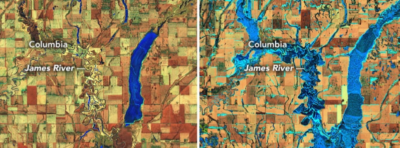
Image credit: USGS LANDSAT-8/OLI
Flooding on James River in South Dakota has been persisting for more than a year now. During the 2019 flood season, the water levels reached 4.9 m (16.2 feet)– its highest since 2010. This spring, forecasters are expecting major to moderate inundations in 23 states, including some areas hit by last year's significant flooding– especially in North Dakota, South Dakota, and Minnesota.
In March 2019, a bomb cyclone dumped heavy rains that triggered flooding in the area, which has been occurring until the present.
Six river gauges on the James River in eastern South Dakota– Columbia, Stratford, Ashton, Huron, Forestburg, and Mitchell– have been above flood stage for more than 300 days. Stratford and Ashton have moderate floods, while the rest have minor inundations.
Many areas in South Dakota recorded twice the average amount of precipitation in 2019. Snow and rainfall were relentless streamflow gages at Columbia and Stratford stay above flood stage since April 2019, according to data from the U.S. Geological Survey (USGS).
The James River flows into the Missouri River at the border between Nebraska and South Dakota, heading eventually into the Gulf of Mexico.
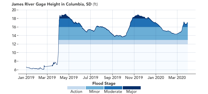
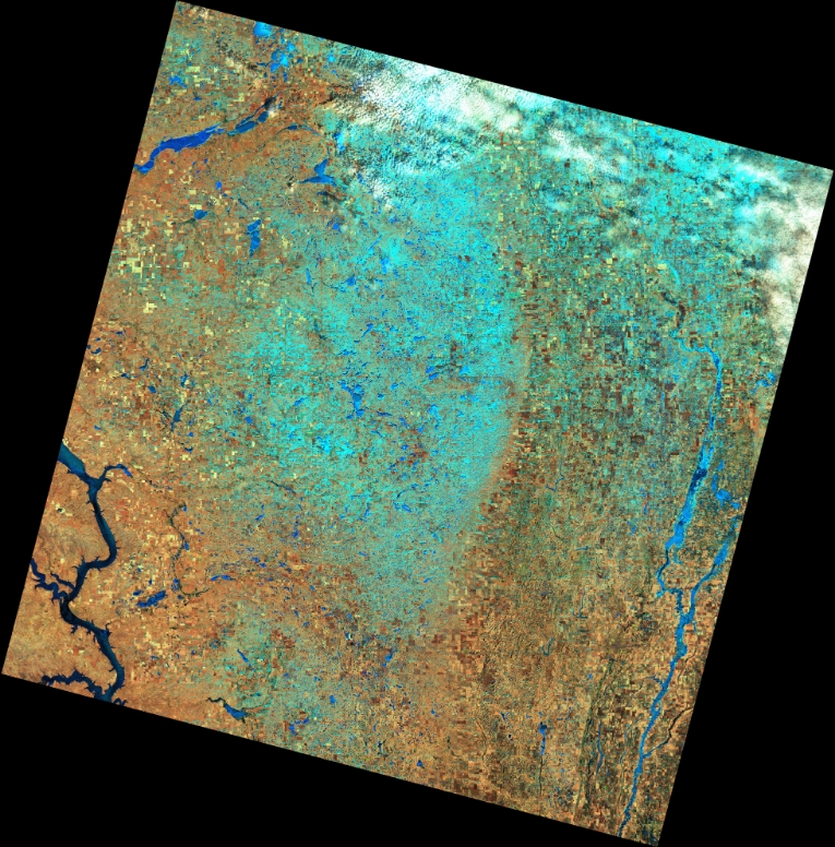
Image credit: NASA Earth Observatory
On March 23, 2020, the Operational Land Imager (OLI) on Landsat 8 took an image showing the high water levels on the James River– a tributary of the Missouri River in eastern South Dakota. In another image taken in March 2015, it shows the same region during a more typical spring.
Most of the present flooding on the James River is contained in low-lying or agricultural areas.
"The river levels never fell in the winter because the ground was fully saturated when it froze last fall," Amy Parkin explained, a meteorologist at the National Weather Service office in Aberdeen.
"As the snow and river ice melted over the past few weeks, the water had nowhere to go," she added.
The unusually flat landscape in the area has also contributed to the floodwater's length. The elevation along the river only drops around 30 m (100 feet) from the borders of North Dakota to Nebraska.
"The riverbanks are fairly low, and the water does not flow quickly. When there is a strong south wind, we have actually seen the river flow north," Parkin noted.
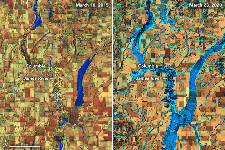
Image credit: USGS LANDSAT-8/OLI
March 10, 2015. Image credit: USGS LANDSAT-8/OLI
March 23, 2020. Image credit: USGS LANSAT-8/OLI
The National Oceanographic and Atmospheric Administration (NOAA) said widespread flooding is expected this spring, April 2020, but it will not be as severe or prolonged as the historic floods in 2019 in dozens of states along the rivers of Mississippi, Missouri, and Arkansas.
NOAA added that major to moderate flooding is possible in 23 states, from the Northern Plains to the Gulf Coast. The most significant flooding is likely in parts of the Dakotas and Minnesota, which were hit by last year's severe flooding.
Each March, NOAA issues its Spring Outlook. Started 30 years ago, the outlook helps agencies and the public prepare for spring hazards. Read more: https://t.co/0XLBuLOi3o #NWS150 pic.twitter.com/38Xa7m29hB
— National Weather Service (@NWS) March 20, 2020
James River (SD) is setting records for a number of locations & length of time above flood stage. #SDwx #SDflood @NWSAberdeen @NWSSiouxFalls pic.twitter.com/wl4ZRpqqMA
— NWS MBRFC (@NWSMBRFC) January 28, 2020
Commenting rules and guidelines
We value the thoughts and opinions of our readers and welcome healthy discussions on our website. In order to maintain a respectful and positive community, we ask that all commenters follow these rules.