
Extreme Heat Watches and Heat Advisories issued across Illinois, Missouri, Kansas, Iowa, Nebraska, and South Dakota
Heat Advisories and Extreme Heat Watches have been issued across parts of Illinois, Missouri, Kansas, Iowa, Nebraska and South Dakota ahead of intensifying heatwave beginning Sunday, June 28, 2026. Heat index values are forecast to exceed 38°C (100°F) across much of the region, with some areas expected to reach 41 to 43°C (105 to 110°F) through Tuesday or Thursday, depending on location.
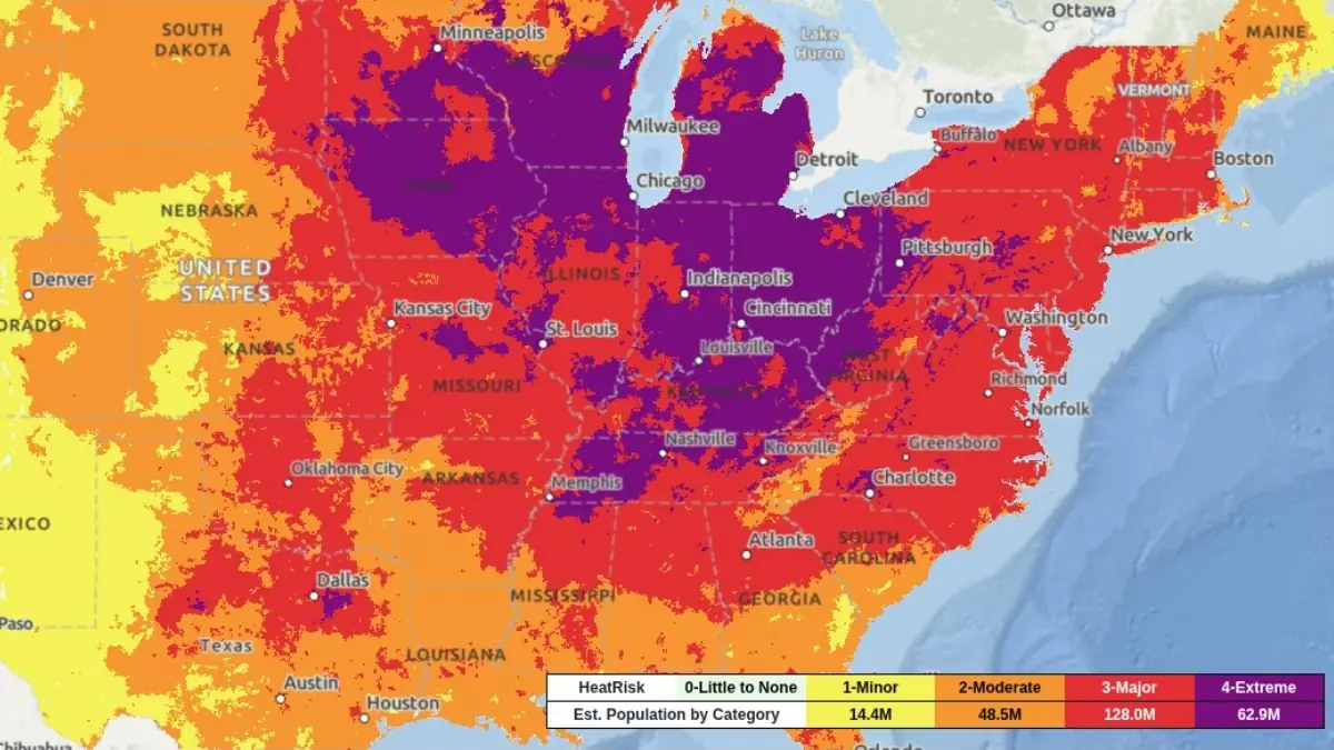
Heat Index for July 2, 2026. Credit: NWS/WPC
A widespread period of dangerous heat is expected to affect large portions of the central United States through next week into the July 4 weekend.
National Weather Service offices across the country have issued Heat Advisories and Extreme Heat Watches covering parts of Kansas, Missouri, Illinois, Iowa, Nebraska, and South Dakota.
Heat indices of over 38°C (100°F) across many locations, while several areas could experience peak values between 41 and 43°C (105 and 110°F).
Kansas
Heat Advisories are in effect from 13:00 CDT Sunday, June 28, until 21:00 CDT Wednesday, July 1, across central, east-central, south-central, and southeast Kansas, where heat index values of 38 to 41°C (100 to 105°F) are forecast.
An Extreme Heat Watch covers north-central, northeast, and east-central Kansas from Sunday afternoon through Tuesday evening, June 30, with peak heat index values potentially reaching 42°C (108°F). Eastern Kansas, including areas near the Missouri border, is also included in a broader Extreme Heat Watch covering adjacent portions of Missouri through Tuesday evening.
Illinois and Missouri
Heat Advisories cover broad areas of southern, central, and western Illinois together with central, eastern, northeastern, southeastern, and western Missouri from Sunday afternoon through Thursday night, where daily heat index values above 38°C (100°F) are expected. These advisories will be effective between 12:00 and 13:00 CDT on Sunday, June 28, and remain in effect until either 20:00 CDT or 00:00 CDT Friday, July 3, depending on the forecast area.
Meanwhile, an Extreme Heat Watch is in effect for the St. Louis metropolitan region—including Madison, Monroe, and St. Clair counties in Illinois and Jefferson, St. Charles, St. Louis County, and St. Louis City in Missouri—from Sunday afternoon, June 28, through Thursday evening, July 2, where heat index values of 41 to 43°C (105 to 110°F) are possible. Additional Extreme Heat Watches cover northeast Missouri and portions of western Illinois from Sunday afternoon through Tuesday evening, June 30.
Iowa
Heat Advisories begin at 13:00 CDT Sunday, June 28, across northwest, west-central, and southwest Iowa. Depending on location, the advisories remain in effect until either 21:00 CDT Monday, June 29, or 21:00 CDT Tuesday, June 30, with forecast heat index values generally ranging from 39 to 41°C (103 to 105°F).
Much of Iowa is also under an Extreme Heat Watch from Sunday afternoon through Tuesday evening, June 30, while southwest Iowa is included in a separate watch for the Omaha metropolitan area, where heat index values may approach 42°C (108°F).
Nebraska and South Dakota
Heat Advisories will start going into effect at 13:00 CDT Sunday, June 28, across Nebraska. Advisories for eastern and southeastern Nebraska remain in effect until 21:00 CDT Tuesday, June 30, while Cedar and Knox counties in northeast Nebraska are under a shorter-duration advisory until 21:00 CDT Sunday.
In southeast South Dakota, most advisories remain in effect from 13:00 CDT Sunday until 21:00 CDT Monday, although Bon Homme, Hanson, Hutchinson, and McCook counties are under a one-day advisory ending at 21:00 CDT Sunday.
Heat index values are expected to reach 39 to 41°C (103 to 105°F). Douglas and Sarpy counties in Nebraska, together with adjacent counties in southwest Iowa, are also under an Extreme Heat Watch from Sunday afternoon through Tuesday evening, June 30, where heat index values may reach 42°C (108°F).
The National Weather Service warns that prolonged exposure to these conditions can significantly increase the risk of heat-related illnesses, particularly during the afternoon and early evening when apparent temperatures are highest. Several forecast areas are also expected to experience unusually warm overnight conditions that will limit overnight cooling and increase cumulative heat stress over successive days.
Residents across affected areas are urged to remain hydrated, limit strenuous outdoor activity during the hottest part of the day, seek air-conditioned environments whenever possible, and continue monitoring official forecasts for additional advisories, watches, or warnings.
References:
1 Extreme Heat Watch – NWS – June 27, 2026
2 Heat Advisory – NWS – June 27, 2026

I am an Assistant Editor and Severe Weather & Science Journalist at The Watchers, specializing in real-time severe weather coverage, geophysical event reporting, and research-driven scientific analysis. You can reach me at rishav(at)watchers(.)news.
Commenting rules and guidelines
We value the thoughts and opinions of our readers and welcome healthy discussions on our website. In order to maintain a respectful and positive community, we ask that all commenters follow these rules.