
Ex-tropical Cyclone “Esther” dumps a month’s worth of rain on Melbourne– city’s highest March rainfall since 1929, Australia
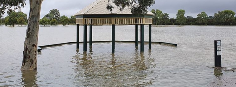
Image credit: Kimba Hodgetts
More than a month's worth of rain brought by the remnants of Ex-tropical Cyclone "Esther" soaked Melbourne overnight March 5, 2020, resulting in widespread flooding and major damage to buildings. The city recorded 54.6 mm (2.1 inches) of rain in a 24-hour period, which is higher than the city's usual total for the entire month of March. The amount was also the highest rainfall for the month since 1929.
The system produced flash flooding, toppled trees, and damaged buildings and properties. The state emergency service had to attend to more than 300 calls, mostly for ruined establishments and vehicles submerged in water.
According to state response controller Alistair Drayton, it took only 10 to 15 mm (0.4 to 0.6 inches) of water for smaller cars to float. Motorists were advised to take extreme caution and avoid driving through inundated roads.
Rail travel disruptions were also reported, including the Hurstbridge line which was temporarily suspended and Burnley Station which saw major inundations.
Elwood canal. #melbourneweather pic.twitter.com/eql021c2Dc
— Lauren Gannon (@postedbylg) March 4, 2020
The Yarra is looking fine on the commute home.
Darebin Ck absolutely pumping below Heidelberg Rd. #melbourneweather pic.twitter.com/PsBSqizHsa
— Christopher Watson (@Birds_Central) March 5, 2020
This is a creek near my place.#melbourneweather pic.twitter.com/AdKTqrN2vA
— Sarah Taylor (@SarahJMTaylor) March 5, 2020
WOW! No BBQ's here today! This shot was taken in Centre Road, Berwick by Kimba Hodgetts. @JaneBunn @abcmelbourne @3AW693 @StormHour #melbourneweather #melbweather #Melbourne pic.twitter.com/zqgzi3RsWy
— Vic Storm Chasers (@VicStormChasers) March 5, 2020
Seaford got hit hard with rain today pt2 #melbourneweather pic.twitter.com/vN1WGcsnJ2
— Corey | Kawrie (@zKawrie) March 5, 2020
The heavy downpour was dumped by the remnants of Ex-tropical Cyclone "Esther," which traveled from northern Australia to the southeast. Meteorologists said they did not expect it to reach as far as Melbourne.
"It is particularly unusual because usually, these sorts of troughs weaken out before they make it this far south," said Bureau of Meteorology (BOM) duty forecaster Miriam Bradbury.
"They generally move east or die off, but this one has moved down to the southeast, so that's why we're getting tropical moisture and humidity."
BOM meteorologist Peter Otto said the amount of rainfall that hit Melbourne was the highest rainfall for March since 1929. The average rainfall for Victoria in March is 50.1 mm (1.97 inches).
According to meteorologist Jane Bunn, there will be full sunshine for the weekend into Monday, March 9.
A mass of moisture from ex Tropical Cyclone Esther is heading our way, bringing rain to #Victoria North-eastern #Victoria is in for a drenching with possible flooding in some areas – see latest warnings: https://t.co/aLu2YSmGXo pic.twitter.com/DyODoBPnJ6
— Bureau of Meteorology, Victoria (@BOM_Vic) March 4, 2020
Why was #Melbourne wetter than forecast?
Yesterday's guidance (24hr rain to 11am today) pointed to peak rainfall totals to the northeast.
In fact, the moisture and rain tracked further west than expected, bringing heavier rainfall to central Vic as well as the NE. pic.twitter.com/iA6MfkM9HN— Bureau of Meteorology, Victoria (@BOM_Vic) March 4, 2020
Commenting rules and guidelines
We value the thoughts and opinions of our readers and welcome healthy discussions on our website. In order to maintain a respectful and positive community, we ask that all commenters follow these rules.