
Area along major river in Japan almost entirely submerged in flood following destructive Typhoon “Hagibis”
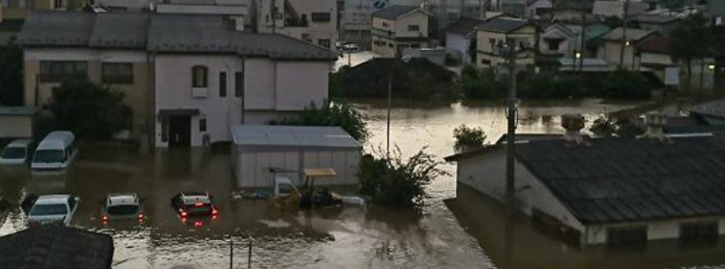
Image credit: @aizukeirin/Twitter
The area along the Abukuma River in northeastern Japan was almost totally submerged in floodwater as an aftermath of chaotic Typhoon "Hagibis," which made landfall in Shizuoka Prefecture on October 12, 2019. The storm dumped massive rains, in parts record-breaking, making the river swell.
Experts said it's very unusual for almost all areas along such a major river to be flooded.
Abukuma is designated as a class A river, which means it is deemed to be significant to the country's economy and conservation of nature. Floods from the said river contributed to the deadly damage in the area. 45 people were reportedly killed by the storm in the prefectures of Fukushima and Miyagi, accounting for 60% of all victims.
Prefectural and municipal governments manage the upper reaches of the Abukuma River, while the central government looks after the middle reaches.
Japanese news outlet The Mainichi Shimbun reported that an estimate of 12 600 ha (31 135 acres) along some parts of the river and its branches were flooded.
【Typhoon#19(13 oct 2019)】Large flood at Abukuma river in Fukushima city
13日午前、台風19号の影響で増水した阿武隈川=2019年10月13日午前、福島市 pic.twitter.com/zl4n6sVogo
— Orion's tale (@TaleOrion) October 14, 2019
住宅周り完璧冠水しました。
身動きが全く取れないので、しばらくぼーっとしてます#台風 #福島県 #郡山市 #阿武隈川 pic.twitter.com/EnJ5N4DS8X— こー (@www_blowin_) October 12, 2019
As predicted, the typhoon dumped exceptionally heavy rain, more than 1 m (39 inches) in places or 30 to 40% of average annual rainfall in just 24 and 48 hours.
The resort town of Hakone in Kanagawa Prefecture recorded 942.3 mm (37.1 inches) in 24 hours on October 12, setting a record for that location. 685.8 mm (27 inches) of rain was registered in heavily forested Shizuoka Prefecture southwest of Tokyo. Downtown Tokyo received unusually high 203.2 mm (8 inches) of rain in the same period. Higher elevations just west of downtown Tokyo registered record 599.4 mm (23.6 inches) of rain.
The Ministry of Land, Infrastructure, Transport and Tourism confirmed 48 landslides and mudflows in 12 prefectures and the collapse of levees at 10 locations on 9 rivers by 12:00 LT, October 13.
"It has been rare in recent years, when flood-control measures have been implemented, for areas extending from the upper to lower reaches of a river to be flooded," said Osamu Itagaki, head of the Flood Disaster Prevention Division of National Institute for Land and Infrastructure Management.
According to experts, the entire area was almost submerged in floodwaters due to the fact that the typhoon path was almost identical to that of the river stream. The Abukuma River flows from south to north, the same direction as Hagibis' direction.
The water level in the upper reaches typically rises first when heavy rains affect rivers, while the level downstream rises afterward. In the current disaster, the water level downstream remained high following the torrential rains. This and a large amount of water from the upper reaches seemingly lead to breaches in the dike in several areas. It burst at seven places in Fukushima Prefecture. Abukuma's swelling also caused its branches to burst. The dikes of 16 branches were not able to withstand the pressure and spread across 34 locations.
According to the Land, Infrastructure, Transport and Tourism Ministry, about 30% of collapsed dikes are located along the Abukuma River. The ministry also reported that after the storm, over 100 river embankments collapsed, leaving 33 000 homes flooded and 2 000 homes partially or totally damaged. More than 77 deaths have been recorded.
Commenting rules and guidelines
We value the thoughts and opinions of our readers and welcome healthy discussions on our website. In order to maintain a respectful and positive community, we ask that all commenters follow these rules.