
Earthquakes in the Kermadecs – another M6.3 hits the area, what you need to know, New Zealand
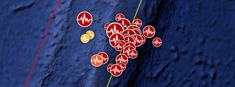
Image credit: Google, TW/SAM
Another strong and shallow earthquake registered by the USGS as M6.3 hit Kermadec Islands region at 11:04 UTC on June 27, 2019. The quake follows M7.2 on June 15, M6.3 on June 16, M6.0 on June 17, M6.4 on June 19, M6.2 on June 21 and dozens of moderately strong earthquakes.
Like the previous M6+ events, today's M6.3 was located about 120 km (75 miles) NNW of L'Esperance Rock at a depth of 10 km (6.2 miles).
There is no tsunami threat from this earthquake.
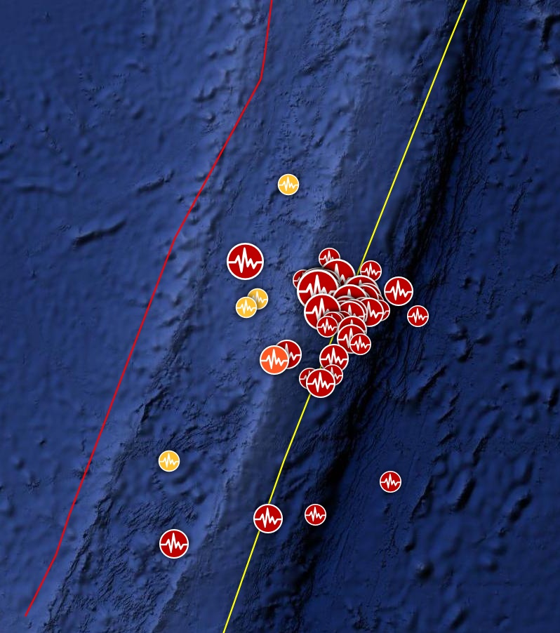
Kermadec Islands earthquakes by June 27, 2019. Credit: Google, TW/SAM
- 6.3
120km NNW of L'Esperance Rock, New Zealand
2019-06-27 11:04:57 (UTC)
- 5.3
159km ENE of L'Esperance Rock, New Zealand
2019-06-26 18:06:29 (UTC)
- 4.8
172km ENE of L'Esperance Rock, New Zealand
2019-06-25 22:35:41 (UTC)
- 5.9
159km ENE of L'Esperance Rock, New Zealand
2019-06-24 11:34:08 (UTC)
- 5.3
140km ENE of L'Esperance Rock, New Zealand
2019-06-23 06:52:12 (UTC)
- 4.9
177km ENE of L'Esperance Rock, New Zealand
2019-06-22 22:35:05 (UTC)
- 5.1
192km SSE of Raoul Island, New Zealand
2019-06-21 23:00:22 (UTC)
- 5.1
153km ENE of L'Esperance Rock, New Zealand
2019-06-21 22:49:25 (UTC)
- 5.0
146km ENE of L'Esperance Rock, New Zealand
2019-06-21 08:50:16 (UTC)
- 6.2
156km ENE of L'Esperance Rock, New Zealand
2019-06-21 08:37:20 (UTC)
- 5.3
130km ENE of L'Esperance Rock, New Zealand
2019-06-21 07:27:43 (UTC)
- 5.1
152km ENE of L'Esperance Rock, New Zealand
2019-06-20 21:45:06 (UTC)
- 5.0
256km S of L'Esperance Rock, New Zealand
2019-06-20 05:24:44 (UTC)
- 4.9
132km ENE of L'Esperance Rock, New Zealand
2019-06-19 23:05:45 (UTC)
- 4.6
107km ENE of L'Esperance Rock, New Zealand
2019-06-19 13:49:42 (UTC)
- 6.4
140km NE of L'Esperance Rock, New Zealand
2019-06-19 07:01:42 (UTC)
- 5.2
126km ENE of L'Esperance Rock, New Zealand
2019-06-18 23:59:09 (UTC)
- 5.2
126km E of L'Esperance Rock, New Zealand
2019-06-18 23:24:23 (UTC)
- 5.0
128km ENE of L'Esperance Rock, New Zealand
2019-06-18 23:04:38 (UTC)
- 5.2
124km NE of L'Esperance Rock, New Zealand
2019-06-18 18:12:08 (UTC)
- 5.4
128km E of L'Esperance Rock, New Zealand
2019-06-18 17:21:48 (UTC)
- 5.9
135km ENE of L'Esperance Rock, New Zealand
2019-06-18 16:05:17 (UTC)
- 4.9
255km SSE of L'Esperance Rock, New Zealand
2019-06-18 07:20:24 (UTC)
- 5.1
121km ENE of L'Esperance Rock, New Zealand
2019-06-18 04:23:54 (UTC)
- 5.1
165km ENE of L'Esperance Rock, New Zealand
2019-06-18 01:16:00 (UTC)
- 5.5
151km ENE of L'Esperance Rock, New Zealand
2019-06-17 16:53:04 (UTC)
- 4.4
130km ENE of L'Esperance Rock, New Zealand
2019-06-17 16:36:47 (UTC)
- 4.3
230km E of L'Esperance Rock, New Zealand
2019-06-17 14:36:04 (UTC)
- 4.9
140km SSE of Raoul Island, New Zealand
2019-06-17 12:10:07 (UTC)
- 4.7
150km ENE of L'Esperance Rock, New Zealand
2019-06-17 10:47:34 (UTC)
- 4.9
95km ENE of L'Esperance Rock, New Zealand
2019-06-17 09:57:23 (UTC)
- 6.0
135km ENE of L'Esperance Rock, New Zealand
2019-06-17 06:02:05 (UTC)
- 4.8
93km SE of L'Esperance Rock, New Zealand
2019-06-17 04:49:46 (UTC)
- 4.9
109km ENE of L'Esperance Rock, New Zealand
2019-06-17 02:05:43 (UTC)
- 4.4
108km NE of L'Esperance Rock, New Zealand
2019-06-17 01:54:29 (UTC)
- 4.9
128km ENE of L'Esperance Rock, New Zealand
2019-06-17 00:11:01 (UTC)
- 5.0
98km SE of L'Esperance Rock, New Zealand
2019-06-16 23:20:01 (UTC)
- 4.9
125km ENE of L'Esperance Rock, New Zealand
2019-06-16 22:28:24 (UTC)
- 4.9
119km ENE of L'Esperance Rock, New Zealand
2019-06-16 22:20:17 (UTC)
- 5.5
102km ESE of L'Esperance Rock, New Zealand
2019-06-16 20:58:26 (UTC)
- 4.6
160km ENE of L'Esperance Rock, New Zealand
2019-06-16 16:41:32 (UTC)
- 4.9
104km ENE of L'Esperance Rock, New Zealand
2019-06-16 15:23:38 (UTC)
- 6.3
93km ENE of L'Esperance Rock, New Zealand
2019-06-16 05:17:16 (UTC)
- 4.3
139km E of L'Esperance Rock, New Zealand
2019-06-16 04:39:12 (UTC)
- 4.7
127km NE of L'Esperance Rock, New Zealand
2019-06-16 03:10:31 (UTC)
- 5.5
119km NE of L'Esperance Rock, New Zealand
2019-06-16 03:02:39 (UTC)
- 5.0
119km NE of L'Esperance Rock, New Zealand
2019-06-16 01:29:42 (UTC)
- 4.6
130km NE of L'Esperance Rock, New Zealand
2019-06-16 00:53:59 (UTC)
- 4.5
106km ESE of L'Esperance Rock, New Zealand
2019-06-16 00:39:31 (UTC)
- 4.6
99km NE of L'Esperance Rock, New Zealand
2019-06-16 00:12:50 (UTC)
- 4.5
119km NE of L'Esperance Rock, New Zealand
2019-06-16 00:07:58 (UTC)
- 5.0
119km NE of L'Esperance Rock, New Zealand
2019-06-16 00:00:07 (UTC)
- 4.4
124km NE of L'Esperance Rock, New Zealand
2019-06-15 23:58:50 (UTC)
- 4.4
111km NE of L'Esperance Rock, New Zealand
2019-06-15 23:36:01 (UTC)
- 4.5
121km NE of L'Esperance Rock, New Zealand
2019-06-15 23:30:03 (UTC)
- 4.0
114km NNE of L'Esperance Rock, New Zealand
2019-06-15 23:13:38 (UTC)
- 5.3
121km NE of L'Esperance Rock, New Zealand
2019-06-15 23:07:24 (UTC)
- 5.3
115km NE of L'Esperance Rock, New Zealand
2019-06-15 23:04:06 (UTC)
- 7.2
103km NE of L'Esperance Rock, New Zealand
2019-06-15 22:55:02 (UTC)
Earthquakes in the Kermadecs
The Kermadec Trench extends from the Hikurangi Subduction Zone off the east coast about 1 300 km (807 miles) towards Tonga. Because it is almost continuous with the Tonga Subduction Zone, it is often referred to as the Tonga-Kermadec Subduction Zone. This trench is a subduction zone where the Pacific Plate is diving westwards under the Australian Plate, just like what is happening below the North Island, GNS scientists explained.
The region hit by M7.2 (USGS, M7.0 GeoNet) on June 16 is subducting faster than that of the Hikurangi Subduction Zone – about 60 mm (2.3 inches) each year, likely making the Kermadec Trench more active than the Hikurangi Subduction Zone.
It generated a very small tsunami at Raoul Island – about 0.1 m (0.3 feet) at the two tsunami gauges operated by GeoNet on the Island. This is not large enough to be regarded as a threat. An earthquake in a similar location would probably need to be in the high M7s, close to M8, to produce a tsunami large enough to be a land threat to New Zealand.
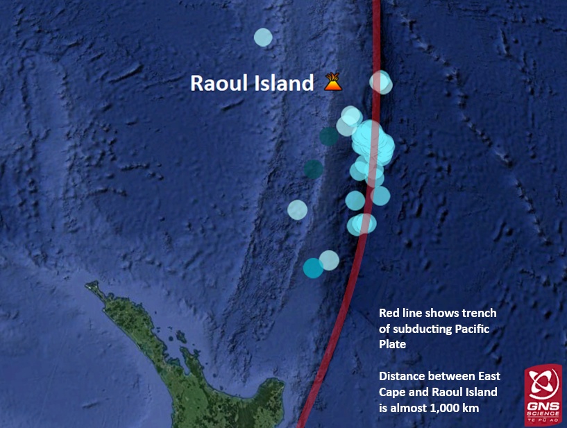
Location of Raoul Island in the Kermadec Islands and earthquakes over M5.0 in the last month (May 20 – June 20, 2019). The subduction zone north of New Zealand is visible in red. Credit: GNS Science
"Our magnitude for this quake is M7.0, however these events are outside the GeoNet network so our magnitude is less than the international agency estimates of around M7.2. We are planning to put out some information soon explaining what different magnitudes mean and why they often differ," GNS Science duty seismologist John Ristau said.
The most vulnerable parts of New Zealand would be the areas along the upper North Island nearest to the epicenter, i.e. parts of Northland/Auckland/Bay of Plenty/East Cape. If the earthquake is large enough, the entire coast of New Zealand would be variously affected by tsunami inundation.
Travel time would be affected by the location of the earthquake. At the southern end of the Kermadec region, it could be less than an hour. If the quake originated further north, it could take about two hours for the first waves to hit the New Zealand coast.
Staying safe – what should we be aware of?
It is important to remember that in seismically active zones, large earthquakes can occur at any time. It is well known that earthquakes occurring in the Kermadec region have the potential to generate tsunamis.
Kermadec earthquakes are not likely to be strongly felt at all of New Zealand’s tsunami-prone coastlines, so it’s important that people know the correct actions to take for a tsunami and how to stay informed – via radio, Emergency Mobile Alerts, social media, and the Ministry of Civil Defence & Emergency Management (MCDEM) website.
New Zealand’s entire coastline is at risk of tsunami inundation – it’s part of the risk of living on such an active plate boundary in the middle of the ocean. Make sure you follow all instructions in official warnings, and if an evacuation warning is issued, get to higher ground immediately.
You can check out Civil Defence’s website for tsunami safety tips – www.civildefence.govt.nz/get-ready/get-tsunami-ready/
How will you know to evacuate?
If you feel a long or strong earthquake, or receive a tsunami warning alert, get to higher ground immediately. Walking or biking is the best mode of transport following a tsunami warning to avoid road congestion.
I'm a dedicated researcher, journalist, and editor at The Watchers. With over 20 years of experience in the media industry, I specialize in hard science news, focusing on extreme weather, seismic and volcanic activity, space weather, and astronomy, including near-Earth objects and planetary defense strategies. You can reach me at teo /at/ watchers.news.
Commenting rules and guidelines
We value the thoughts and opinions of our readers and welcome healthy discussions on our website. In order to maintain a respectful and positive community, we ask that all commenters follow these rules.