
Violent thunderstorm hits Tamaulipas – Texas border region with 300 mm (11.8 inches) of rain in 4 hours
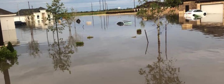
Image credit: Texas Game Warden
Violent thunderstorms hit Tamaulipas, Mexico – Texas, US border region on June 24, 2019, dumping more than 300 mm (12 inches) of rain in 4 hours.
One person died in the municipality of Reynosa, Mexico where floods damaged roads, homes and other buildings in over 50 neighborhoods.
A severe thunderstorm produced sporadic straight line wind damage from Monte Alto to portions of north Elsa during the evening of June 24 with estimated peak winds up to 120 km/h (75 mph), NWS Brownsville said.
Persistent rain bands dumped up to 300 mm (12 inches) of rainfall, with a large swath of 150 – 300 mm (6 – 12 inches) across Weslaco-Harlingen-Raymondville.
Around 50 people were evacuated from flooded homes in Harlingen, Cameron County, TX.
Unexpected rain event caused flash flooding in several areas of the City of Harlingen, Cameron County, city officials said.
"The heavy rainfall temporarily exceeded the five-year designed capacity of the City’s interior storm drainage system. Weather reports indicate more than 317.5 mm (12.5 inches) of rain pounded Harlingen within a 3-4 hour time period. This amount of rainfall is classified between a 100 – 500-year storm event."
Overnight, Texas Game Wardens stationed in Cameron/Hidalgo County assisted local officials of DDC 21 in the RGV in response to severe weather dropping 10+’’ of rain in areas.
Responded to dozens of calls resulting in evacuation of 67 people and 15 pets via TPWD airboats. @TDEM pic.twitter.com/pPMmFQLMDp
— Texas Game Warden (@TexasGameWarden) June 25, 2019
Here is a quick first-hand view of Game Wardens working in the local community during the Rio Grande Valley flooding. #Teamwork pic.twitter.com/gQR7NLz1cv
— Texas Game Warden (@TexasGameWarden) June 26, 2019
Personal de dependencias como @CEAT1, @PCTamaulipas, @Obras_TAM, @SedumaTam y @admon_tam, realiza trabajos de desagüe en colonias de #Reynosa. Más de 70 unidades y equipo, entre camiones, retroexcavadoras, pipas, generadores y bombas, son utilizados para atender las afectaciones. pic.twitter.com/KUSintjfb3
— Fco. Cabeza de Vaca (@fgcabezadevaca) June 25, 2019
El Plan DN-III fue activado desde anoche en #Reynosa para brindar auxilio a la población afectada por inundaciones. Agradezco a la @SEDENAmx, @SEMAR_mx y @PoliciaFedMx por sumarse a las tareas de apoyo. pic.twitter.com/uKkNIsAg5O
— Fco. Cabeza de Vaca (@fgcabezadevaca) June 25, 2019
A severe thunderstorm produced sporadic straight line wind damage from Monte Alto to portions of north Elsa during the evening of June 24th. Peak winds were estimated at 65 to 75 mph. #rgvwx #rgv #txwx #winddamage #winds
For additional information, visit https://t.co/aI9g4hyyDi pic.twitter.com/rETCH8q4TX
— NWS Brownsville (@NWSBrownsville) June 26, 2019
I'm a dedicated researcher, journalist, and editor at The Watchers. With over 20 years of experience in the media industry, I specialize in hard science news, focusing on extreme weather, seismic and volcanic activity, space weather, and astronomy, including near-Earth objects and planetary defense strategies. You can reach me at teo /at/ watchers.news.
Commenting rules and guidelines
We value the thoughts and opinions of our readers and welcome healthy discussions on our website. In order to maintain a respectful and positive community, we ask that all commenters follow these rules.