
8 missing as unusual TC Mekunu hits Socotra, Yemen, landfall expected close to Salalah, Oman
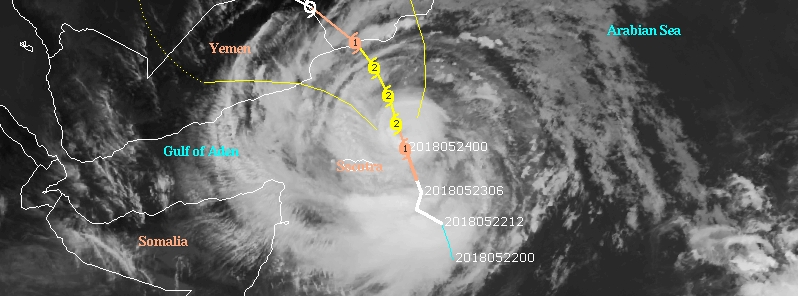
Featured image: Tropical Cyclone "Mekunu" at 05:00 UTC on May 24, 2018. Credit: UW-CIMSS
At least 8 people are missing and hundreds were evacuated as Very Severe Cyclonic Storm "Mekunu" ravaged Yemen's island of Socotra on Wednesday night, May 23, 2018. Mekunu is another unusual tropical cyclone to form in the Arabian Sea within 10 days. The storm is expected to make landfall over the Yemen – Oman border region, close to the southern Omani city of Salalah early May 26 as Category 2 or 3 hurricane equivalent. This will be the first such landfall in satellite era. The region could experience its yearly rainfall average in just one day.
Mekunu brought strong winds and thunderstorms, causing severe flooding and damage to houses across the small island of Socotra. Some of the homes have been completely destroyed as the center of Mekunu moved just east of the island.
"The situation is extremely critical," former governor of the island, Salem Abdullah Al Socotri, said. "The roads are flooded, and we cannot get out of the northern coastal town of Hadibu to see what is going on in other areas of the island. Also, the strong winds have intercepted telecommunications, so we are almost isolated."
Four of the 8 missing were crew on board a boat that sank in the Arabian Sea and are suspected to be dead. At least three vessels have gone off the radar, a source told The National.
Mekunu is the fourth hurricane-strength cyclone to hit southern Yemen in recent years.
Cyclone Sagar hit earlier this month, and in late 2015, Socotra was hit by Cyclone Chapala followed just days later by Cyclone Megh – which destroyed hundreds of homes and killed 18 people on the island.

According to RSMC New Delhi, authority for this part of the world, the Very Severe Cyclonic Storm ‘Mekunu’ over Westcentral & adjoining Southwest Arabian Sea moved further north-northwestwards with a speed of 11 km/h (7 mph) over the past 6 hours. At 05:30 UTC today, it was located about 180 km (112 miles) ENE of Socotra Islands and 440 km (274 miles) SSE of Salalah, Oman.
Gale winds speed was reaching 135 – 145 km/h (85 mph) with gusts to 160 km/h (100 mph).
Mekunu is expected to intensify further during next 24 hours and move nearly northwards during next 24 hours and then north-northwestwards and cross south Oman – southeast Yemen coasts as a Very Severe Cyclonic Storm with wind speed of 160 – 170 km/h (100 – 106 mph) and gust to 190 km/h (118 mph) close to Salalah early Saturday, May 26, 2018.
Salalah has a population of about 200 000, and typically receives just 127 – 203 mm (5 to 8 inches) of rain in an entire year. This means that Mekunu could bring that same amount in under a day, presenting the risk of life-threatening flash flooding, in addition to damage from high winds.

The flood threat will extend to northeastern Yemen and the desert of Saudi Arabia.
According to the National Oceanic and Atmospheric Administration's database, no Category 2 or stronger storm has made landfall in southwestern Oman, making this a unique threat.
The last tropical cyclone with a hurricane-equivalent intensity to track near southwestern Oman's Dhofar Governorate was in May 1959.
I'm a dedicated researcher, journalist, and editor at The Watchers. With over 20 years of experience in the media industry, I specialize in hard science news, focusing on extreme weather, seismic and volcanic activity, space weather, and astronomy, including near-Earth objects and planetary defense strategies. You can reach me at teo /at/ watchers.news.
Commenting rules and guidelines
We value the thoughts and opinions of our readers and welcome healthy discussions on our website. In order to maintain a respectful and positive community, we ask that all commenters follow these rules.