
Tropical Cyclone “Tej” to make landfall in Yemen, bringing extremely heavy rain and significant storm surge
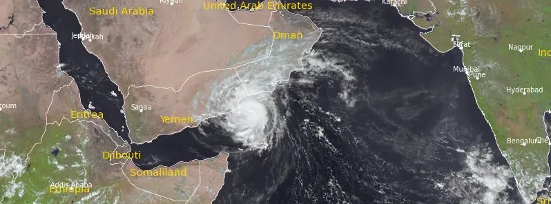
Featured image: Tropical Cyclone "Tej" at 08:45 UTC on October 23, 2023. Credit: EUMETSAT/Meteosat-9, RAMMB/CIRA, The Watchers
Tropical Cyclone “Tej” has slightly weakened but still poses a significant threat to the coasts of Yemen and Oman. Tej is expected to make landfall near Al Ghaidah, Yemen, between 18:00 and 21:00 UTC today, bringing extremely heavy rains, wind speeds of 125 – 135 km/h (79 – 84 mph), gusting to 150 km/h (93 mph), and significant storm surge.
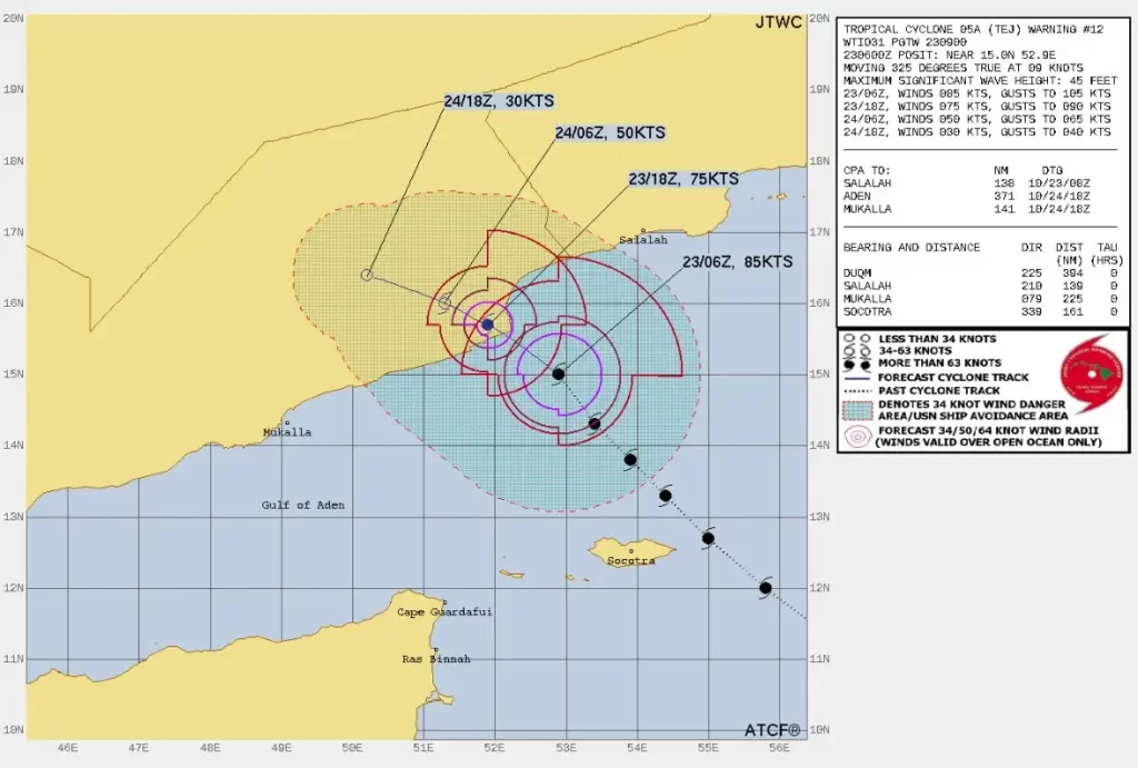
At 03:00 UTC on October 23, the center of Tropical Cyclone “Tej” (Very Severe Cyclonic Storm) was located about 230 km (142.9 miles) north-northwest of Socotra, Yemen, 280 km (173.9 miles) south-southwest of Salalah, Oman, and 200 km (124.3 miles) south-southeast of Al Ghaidah, Yemen, according to RSMC New Delhi.
The system had maximum sustained wind speeds of 155 – 165 km/h (95 – 100 mph), gusting to 180 km/h (112 mph).
Meteorological data indicated minimum cloud top temperatures at -82 °C and revealed dry air incursion reaching up to the core from the western sector. Multisatellite winds showed stronger winds in the northeastern sector of the storm. The estimated central pressure of the system stands at 972 hPa.
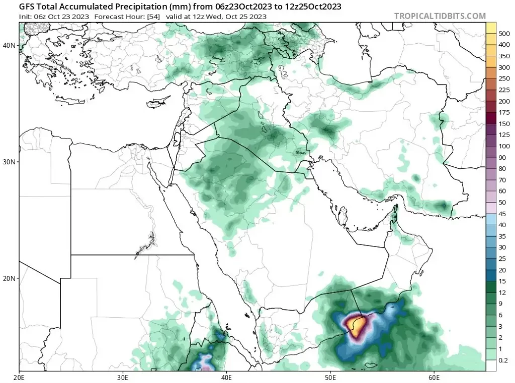
Residents in the path of the storm should be alert to very heavy rains, strong winds and a predicted storm surge of about 2 m (6.6 feet) above the astronomical tide, likely to inundate low-lying areas between Al Ghaydah and Al Faydami near the point of landfall.
Current sea conditions in the southwest Arabian Sea are described as very rough to rough but are expected to improve further from 12:00 UTC today. In contrast, the west-central Arabian Sea is experiencing phenomenal sea conditions, which will continue until 18:00 UTC today, improving gradually to high to very rough by 00:00 UTC of October 24 and rough to very rough by 12:00 UTC of October 24.
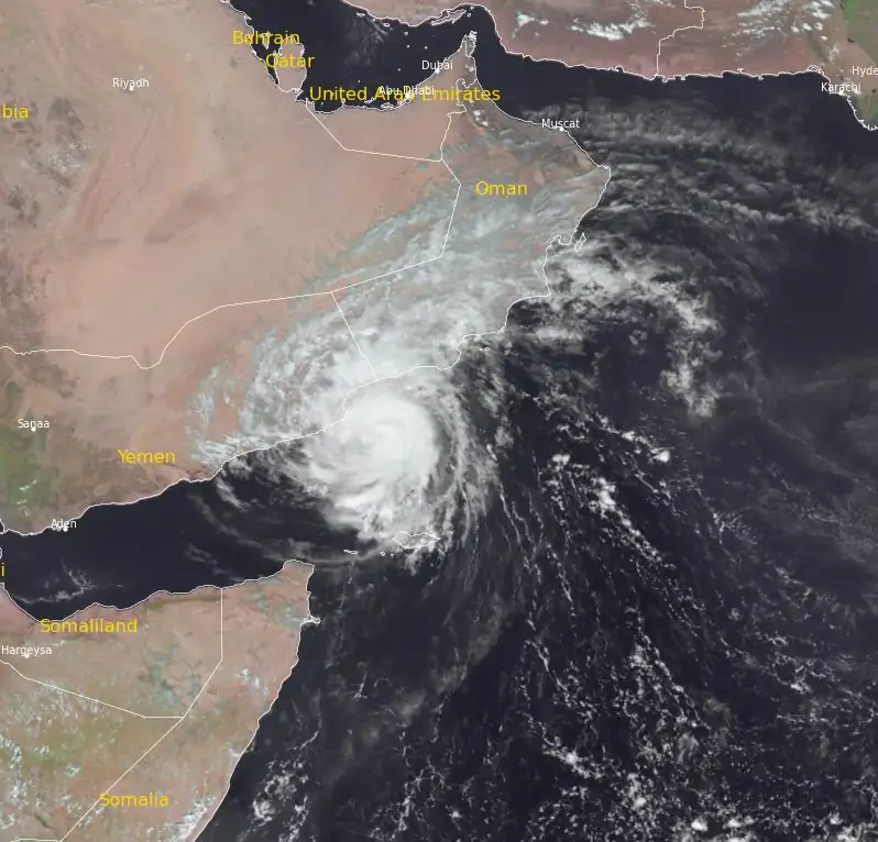
The outer spiral bands of the storm have already entered land, signaling the commencement of land interaction. The system also shows a central dense overcast pattern with well-defined spiral bands.
The storm is expected to cross the Yemen coast close to Al Ghaidah between 18:00 – 21:00 UTC today, with maximum sustained wind speeds of 125 – 135 km/h (79 – 84 mph), gusting to 150 km/h (93 mph).
People living in areas near landfall should be ready for as much as 400 mm (15.7 inches) of rainfall in just 2 days.
Update
Tropical cyclone “Tej’ made landfall on Yemen’s southern coast on October 23, 2023, resulting in at least one death and significant infrastructural damage in Al-Mahra Governorate. The cyclone is expected to weaken and dissipate by October 25.
References:
1 TROPICAL CYCLONE ADVISORY NO. 18 – DEMS-RSMC SPECIAL TROPICAL CYCLONES NEW DELHI – October 23, 2023
The Watchers team and our contributors bring the latest on extreme weather, earthquakes, volcanic eruptions, space weather, and all things science. We're all about making sense of the natural world and keeping you informed on what’s happening. Got a tip or a question? Hit us up using the form at newstips!
Commenting rules and guidelines
We value the thoughts and opinions of our readers and welcome healthy discussions on our website. In order to maintain a respectful and positive community, we ask that all commenters follow these rules.