
Early winter storm to impact West and Plains with heavy snowfall and frigid temperatures
Image credit: GFS/Tropical Tidbits
An early winter storm is set to impact the Northwest and Northern Rockies starting late Tuesday, October 24, 2023. The event, forecasted to bring heavy snowfall and strong winds, will extend into the Northern High Plains by Wednesday.
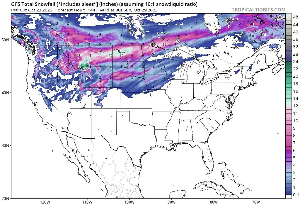
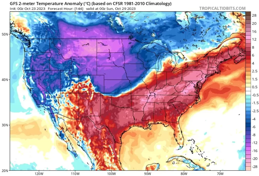
Following a week of near-record warmth, the Northwest and Northern Rockies are bracing for a significant shift in weather conditions. Starting late Tuesday, October 24, 2023, an early winter storm is expected to bring heavy snowfall, with accumulations ranging from 20 to 30 cm (8 to 12 inches) in specific regions. The storm will continue to affect the area beyond the current forecast period, extending into the Northern High Plains by Wednesday.
An upper-level system from the northeastern Pacific will enhance precipitation chances as it drops southward on Tuesday. This will introduce much colder air, lowering snow levels and transforming rain into snow in lower elevations. Accumulations of a few inches are expected through Wednesday.
The National Weather Service has issued winter storm watches for portions of the Cascades and Northern Rockies. NWS Forecaster Putnam warned that this system is part of a frontal boundary extending into the Northern Rockies as early as Monday, where it will initially bring some rain and higher-elevation snow. By late Tuesday, however, the system will mature into a full-fledged winter storm, affecting a broad area.
AccuWeather’s senior meteorologist Bill Deger added that this would be the first major winter weather event of the season. He highlighted the potential for travel disruptions due to locally more than 30.5 cm (1 foot) of snow and strong winds reducing visibility. Moreover, the storm could challenge long-standing record low temperatures, making conditions even more severe.
In anticipation of the storm, AccuWeather Meteorologist Joseph Bauer advised residents to prepare early by unpacking winter gear such as shovels, coats, hats, and gloves. He also recommended ensuring that snow removal equipment like snowblowers is functional.
The event is forecasted to unfold in waves from Monday through Friday, impacting more than a half-dozen states. The transition from dry, near-record warm conditions to a snow-laden and bitterly cold environment marks a significant shift in the region’s weather pattern.
References:
1 Short Range Forecast Discussion – NWS Weather Prediction Center College Park MD – 400 AM EDT Mon Oct 23 2023
2 Significant winter storm to bring near-blizzard conditions, bitter cold to West and Plains – AccuWeather – October 22, 2023
The Watchers team and our contributors bring the latest on extreme weather, earthquakes, volcanic eruptions, space weather, and all things science. We're all about making sense of the natural world and keeping you informed on what’s happening. Got a tip or a question? Hit us up using the form at newstips!
Commenting rules and guidelines
We value the thoughts and opinions of our readers and welcome healthy discussions on our website. In order to maintain a respectful and positive community, we ask that all commenters follow these rules.