
Record rainfall, strong winds and cold blast as extreme weather hits parts of Australia
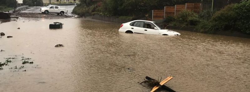
Image credit: ABC News / Georgie Burgess
Extreme weather events have broken historic rainfall records, bringing strong winds and unusually cold conditions across Australia on May 11, 2018.
Tasmania’s capital Hobart experienced a record-breaking rainfall, which caused road closures, schools to shut down, legal proceedings to halt and businesses to be evacuated.
In the 24 hours leading up to 23:00 UTC, May 10 (09:00 local time, May 11), Hobart got its wettest day since 1960 with the city center and surrounding areas receiving more than 120 mm (4.72 inches) of rain.
Meteorologist Sarah Sitton from the Bureau of Meteorology (BoM) said that by the morning of May 11, Mount Wellington had recorded 236 mm (9.29 inches) of rain.
"That was the second-highest-ever May rainfall in a single day for Tasmania. It was the highest rainfall that’s ever been recorded at Mount Wellington," Sitton said.
BoM said: "The multi-headed complex low lurking over and around Tasmania produced a swarm of storms in the southeast, producing high rainfalls." In addition to heavy rains, the storm brought strong winds and over 1 000 lightning strikes.
The Insurance Council of Australia has declared the resultant damage a catastrophe.
Extensive flash flooding caused more than 15 000 homes to lose power and cars to be swept down streets that had become raging streams, The New Daily said.
HOBART FLOODS: Cars have floated away with homes and businesses evacuated, as flash flooding raged through the streets of Tasmania's capital after near record-breaking rainfall. #TenNews pic.twitter.com/CtnlL2qLN0
— TEN Eyewitness News (@channeltennews) May 10, 2018
Video from Hobart’s CBD in Campbell Street just sent to me @togatus_ pic.twitter.com/elup7MEiUh
— Monte Bovill (@MonteBovill) May 10, 2018
State Emergency Services (SES) received more than 400 calls for assistance, in addition to 110 requests for help from the Tasmania Fire Service.
According to SES director Andrew Lea, the flooding was unprecedented.
"I have been in this job for 17 years and I haven’t seen an event of this scale in the Hobart area, so it is very significant," he said.
Hobart flooding declared 'catastrophe' as wild Tasmanian storm eases and tracks north https://t.co/D8yzEPxs0B pic.twitter.com/RvdSMtC1jF
— NewsUpdate24 (@NewsUpdate24Int) 11. toukokuuta 2018
Big clean up job! Riverlet at the front of University of Tasmania broke its banks flooding the streets nearby. #hobart pic.twitter.com/x9CC7HxO2q
— Andrea Rathjen (@aratty67) 11. toukokuuta 2018
The Supreme Court halted all proceedings, advising those affected to contact the court’s telephone advice line, according to The New Daily.
In Hobart, Graham Family Funerals postponed services, Wrest Point Casino closed its doors and education officials shut more than 30 state schools for the day.
Leaks and flooding at the Royal Hobart Hospital led to the closure of 15 beds, including in oncology intensive care and pediatrics. Seven of the beds remained out of action after the hospital lifted its emergency 'code yellow' on the afternoon of May 11.
The University of Tasmania’s also closed its southern campuses.
Two people were also rescued from a car at suburban New Town after they ignored warnings and attempted to drive through flood waters.
Heavy rainfall and damaging winds had cleared in the south of Tasmania, meteorologist Sitton said.
There remained a severe weather warning for central and the northern parts of the state on May 11.
"There will still be some showers around and some fairly blustery conditions but in terms of the heavy rainfall and damaging winds, that’s just today for Tasmania," she said.
Roads in Hobart CBD remain closed and littered with flood debris @abchobart pic.twitter.com/HqHfcW3waE
— Edith Bevin (@EdithBevin) May 10, 2018
Victoria and New South Wales:
Heavy rain affected parts of Melbourne, where roads were flooded and flights delayed on May 11.
With 19 mm (0.75 inches) of rain falling during the early hours of May 11, Melbourne has had more rain over the past 24 hours than the whole of April, BOM said. Mortlake, around 190 km (118 miles) to the west of Melbourne, recorded 44 mm (1.73 inches) in 24 hours. Another 8 to 25 mm (0.31 – 0.98 inches) of rain is expected in Melbourne on May 11 to May 12.
#Melbourne has had more rain over the past 24 hours than the whole of April. Sor far, the city has received 19mm – more to come today #MelbWeather. Severe Weather Warning for heavy rain and damaging winds is current: https://t.co/rX6pypBp6w pic.twitter.com/VClEEYPHmX
— Bureau of Meteorology, Victoria (@BOM_Vic) May 10, 2018
Low temperatures and snow were reported in some areas of New South Wales as cold front swept through the state.
A light dusting covered the Central Tablelands overnight on May 10, with higher mountain peaks receiving a few centimeters.
#NSWWeather #WinterIsComing and it's all happening in Southern and Eastern NSW, Winds, Hazardous Surf, Cold Temperatures and yes Snow. Forecasts at https://t.co/9bj3Jd2TrS pic.twitter.com/1J8seNNRIJ
— Bureau of Meteorology, New South Wales (@BOM_NSW) May 10, 2018
Parts of NSW awoke to snow on Friday morning, as a complex low-pressure system brings wind and cold weather to most of south-east Australia https://t.co/7XSoDBku3B Pics: @nampix pic.twitter.com/bRnQ1BJkdN
— Rachel Clun (@rachelclun) May 10, 2018
A Minus 6 start at #Hotham with 20cn of #snow. Heavy #snowfalls forecast today in the May #coldsnap. ☃ pic.twitter.com/qIo4wyPJd5
— Hotham (@_hotham) May 10, 2018
Commenting rules and guidelines
We value the thoughts and opinions of our readers and welcome healthy discussions on our website. In order to maintain a respectful and positive community, we ask that all commenters follow these rules.