
Numerous snowfall records shattered in Erie, Pennsylvania
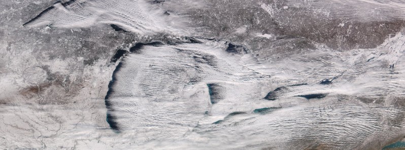
Featured image: Heavy lake-effect snow over the Great Lakes region, US on December 26, 2017. Credit: NASA/NOAA Suomi NPP/VIIRS, UW-CIMSS
A potent winter storm hit parts of the US Mid-West, Mid-Atlantic, and Northeast, dumping heavy snow and creating whiteout conditions in numerous locations over the past couple of days. In its wake, the storm left behind a perfect setup for intense and prolonged lake-effect snow. While many are still witnessing huge amounts, the worst-affected area is in and around Erie, Pennsylvania where numerous snowfall records were already broken and city officials declared a Snow Emergency.
An all-time daily snowfall record for the city of Erie was shattered on Monday, December 25, 2017, after a potent storm dumped 86.3 cm (34 inches) of snow at Erie Airport. This is more than four times its previous record for December 25 of 20.5 cm (8.1 inches). The amount also smashed the city's snowiest single day record of 50.8 cm (20 inches) recorded on December 11, 1956.
Another 62.2 cm (24.5 inches) fell by Tuesday night, bringing the total since December 23 to 159.7 cm (62.9 inches) and breaking the entire state of Pennsylvania 2-day total of 111.7 cm (44 inches), recorded in Morgantown on December 20 and 21, 1958.
It also beat the 13-day record snowfall for Erie of 134.1 cm (52.8 inches) recorded from December 31, 1998 to January 12, 1999.
Since the start of the month, the city of Erie saw 246.4 cm (97 inches) of snow, breaking its previous monthly record of 169.9 cm (66.9 inches) measured in December 1989.
On average, Erie receives 257 cm (101 inches) of snow per year and 70.6 cm (27.8 inches) from December 1 – 31.
The 159.7 cm (62.9 inches) of snow for the storm is the 4-day total (December 23 – 26) while the lake-effect storm total from December 24 to 26 is 153.6 cm (60.5 inches).
The prolonged lake-effect snow conditions forced the City of Erie officials to declare a Snow Emergency on Tuesday morning (December 26). Lake-effect warning continued into Wednesday, December 27 with additional 30 cm (12 inches) of snow likely.
"Roads are dangerous and impassable," the Erie Police Department said. "This is an incredible amount of snow that we're trying to move and appreciate resident cooperation. Residents should stay off of City of Erie streets until it stops snowing, and we can get the roads open."
The city was prepared for an onslaught of snow that hit the city beginning Sunday night, but not the magnitude of snow, Mayor Joe Sinnott said Tuesday morning.
The Pennsylvania Department of Transportation has restricted commercial vehicle and motorcycle traffic on parts of Interstate 86 and Interstate 90 because of the snowstorm shortly before 09:00 EST Tuesday on I-86 and I-90 from the New York line to the Interstate 79 interchange. Included in the restriction are lightly-loaded or empty tractor-trailers, recreational vehicles, non-commercial vehicles towing trailers and motorcycles, according to a release issued by PennDOT.
Speed limits have been reduced to 72 km/h (45 mph) on the interstates in Erie County and the agency is urging motorists to avoid unnecessary travel.
The Millcreek Township has joined Erie in declaring a snow emergency on Tuesday. "Because of the snow emergency, drivers are not permitted on township roads without snow tires or chains. Any person found driving without them may be subject to fines," they said in a press release and also suspended the eight-hour notice for vehicles parked on roads. "There is no on-street parking allowed during the snow emergency, and vehicles will be towed without notice."
Forecast
A stalled frontal boundary over the Great Lakes region will continue to provide a focus for snow generation, NWS forecaster Amy Campbell said 08:53 UTC today.
"With the persistent westerly winds and cold air traveling across the Great Lakes region, heavy lake effect snow will continue downwind of the lakes," she said.
This setup will become less favorable once the Arctic high pressure shifts toward the Great Lakes on Thursday, December 28. A vast area spanning from the High Plains to New England will continue to be affected by the Arctic airmass. Wind Chill Advisories, along with a handful of Wind Chill Warnings are in effect, she added.
In parts of the Pacific Northwest, a steady stream of onshore flow will continue to spread rain and snow to the higher elevations of the Northwest, Northern Rockies, and the adjacent High Plains.
There will be a significant uptick in the amount of moisture moving into the region as a strong Pacific front moves onshore. Precipitation amounts will increase…also, pockets of freezing rain will be possible in the lower elevations in western Washington and Oregon. However, the heaviest snow will occur beyond the short term period, Campbell said.
I'm a dedicated researcher, journalist, and editor at The Watchers. With over 20 years of experience in the media industry, I specialize in hard science news, focusing on extreme weather, seismic and volcanic activity, space weather, and astronomy, including near-Earth objects and planetary defense strategies. You can reach me at teo /at/ watchers.news.
Can somebody do me a favour and compare the data on snowfall with volcanic eruption events. I am pretty sure that such things go hand in hand. If I am wrong would someone kindlyput me out of my mystery?