
Winter weather impacts Appalachians and Mid-Atlantic while severe storm risk expands across parts of Oklahoma and Kansas
A lifting frontal boundary draped from the southern Plains to the Mid-Atlantic is producing a swath of mixed winter precipitation across the Ohio and Tennessee Valleys on March 2, 2026, while setting the stage for isolated severe thunderstorms in Oklahoma and Kansas on March 3. Winter weather advisories are in effect from Indiana to Pennsylvania, with ice accretion possible across the higher terrain of the Appalachians, according to the Weather Prediction Center.
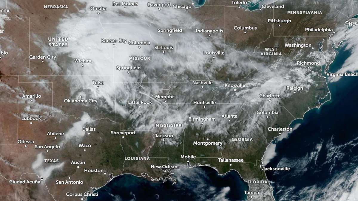
Satellite image of central and eastern U.S. at 01:40 UTC on March 2, 2026. Credit: NOAA/GOES-19, Zoom Earth, The Watchers
A broad frontal system extending from the southern Plains to the Mid-Atlantic is driving a complex pattern of mixed precipitation and convection across much of the central and eastern United States.
Rain, snow, and sleet are spreading through the Ohio and Tennessee Valleys. A mid-level disturbance is tracking along a stationary boundary over the southern states, enhancing lift and bringing widespread precipitation.
Winter Weather Advisories are in effect from Indiana to Pennsylvania, with snow and mixed sleet reported across much of the region.
Ice accretion will be the main hazard across the higher terrain of the Appalachians, with most areas being forecast to see 0.025–0.1 inch (0.6–2.5 mm) of ice, while the Virginia and West Virginia mountains could accumulate 0.1–0.3 inch (2.5–7.5 mm).
Areas west of I-95 for the Baltimore and Washington metros may see 2.5–5 cm (1–2 inches) of snow during the morning of March 2, into the afternoon, with a transition to freezing rain possible during the night.
Meanwhile, a cold front currently over northern Texas is forecast to stall and then lift northward as a warm front on March 3.
As warm, moist air from the Gulf of Mexico surges northward into Oklahoma and Kansas, the Storm Prediction Center (SPC) forecasts isolated severe thunderstorms in the region. A Marginal Risk is in effect for portions of the central Plains, with large hail as the main threat and gusty winds possible where convection organizes.
The Weather Prediction Center (WPC) has issued a Marginal Risk for Excessive Rainfall extending from Missouri to Ohio. Moisture pooling along the warm front is forecast to produce rainfall totals between 25 and 75 mm (1–3 inches) through March 4.
By midweek, the same frontal system will lift northeastward, allowing a surge of warm air to dominate most of the eastern United States.
Forecast highs will reach 27–29°C (80–85°F) across the South and 24–26°C (75–79°F) in the Ohio and Tennessee Valleys. These values are 10–15°C (18–27°F) above the early March climatological average, marking one of the first broad warm episodes of the 2026 spring transition.
Stormy weather will affect much of the central U.S. during the latter half of the week. “Multiple waves of thunderstorms could bring welcomed rain to the region, but some of it may be locally heavy to bring a flash flooding risk,” said the WPC.
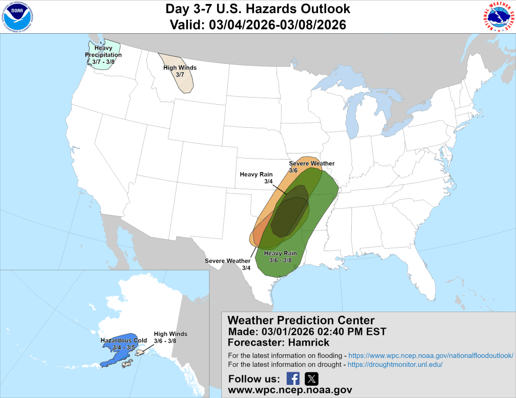
WPC’s 3-7 day hazard outlook shows potential for heavy rain between March 6 and 8, extending from southeastern Texas to southern Missouri. Meanwhile, a risk of Severe Weather extends from Kirksville, Missouri, to Abilene, Texas, through March 6.
References:
1 Short Range Forecast Discussion – NWS/WPC – March 2, 2026

I am an Assistant Editor and Severe Weather & Science Journalist at The Watchers, specializing in real-time severe weather coverage, geophysical event reporting, and research-driven scientific analysis. You can reach me at rishav(at)watchers(.)news.
Commenting rules and guidelines
We value the thoughts and opinions of our readers and welcome healthy discussions on our website. In order to maintain a respectful and positive community, we ask that all commenters follow these rules.