
Continuous eruption at Ambae sends ash to 4 300 m (14 000 feet), Alert Level 3 maintained, Vanuatu
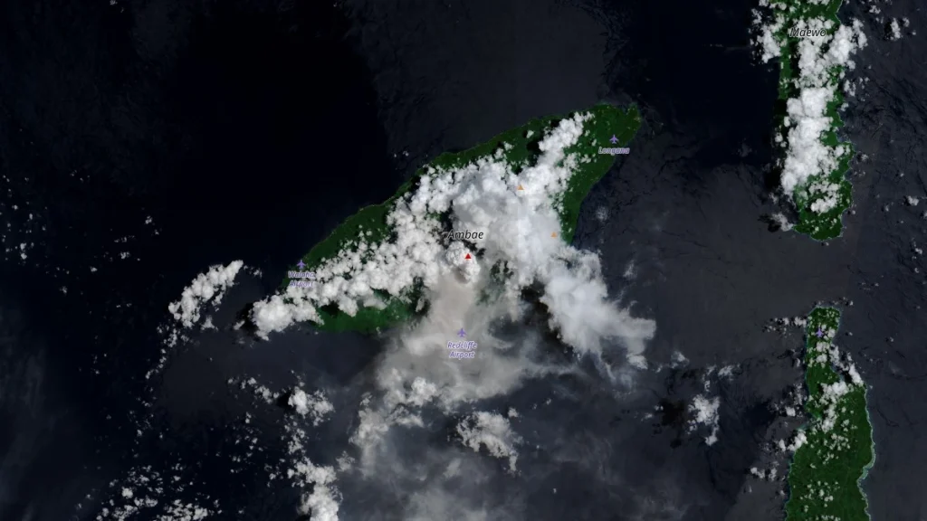
Volcanic ash from Ambae volcano, Vanuatu, was reported at 4 300 m (14 000 feet) above sea level on March 1, 2026. Authorities keep the volcano at Alert Level 3, with activity confined to the summit caldera and hazards limited to a 3 km (1.9 miles) exclusion zone. The ash cloud was observed moving southeast at approximately 28 km/h (17 mph).

Image credit: VMGD
The Wellington Volcanic Ash Advisory Center (VAAC) issued an advisory at 21:53 UTC on March 1, reporting volcanic ash extending from the surface approximately 4 300 m (14 000 feet) above sea level, drifting southeast at 28 km/h (17 mph).
The plume height was estimated using model soundings because the volcano was obscured by meteorological cloud, and ash was not discernible on satellite imagery, although local reports confirmed ashfall. Forecast dispersion modeling indicated continued ash presence within 4 300 m (14 000 feet) layer over the subsequent 6, 12, and 18 hours.
Observations on February 24 reported ash plumes reaching up to 4 900 m (16 000 feet) above sea level during intensified eruptive pulses, representing the highest plume heights documented during the current eruptive phase.
Vanuatu: Ambae Island on alert after volcanic eruption
— Volcaholic (@volcaholic1) February 24, 2026
The government’s Meteorological and Geo-Hazards Department has raised the alert level on Ambae Island to Level 3 out of 5.
Residents are being urged to stay alert.pic.twitter.com/J1gKwHxHRv
Volcanic activity at Ambae began increasing in late November 2025, with continued seismic unrest, gas emissions, and intermittent ash release through December 2025 while the volcano remained at Alert Level 2. Activity intensified during February 12–13, 2026, when strong crater incandescence, elevated sulfur dioxide emissions, and ashfall downwind were reported.
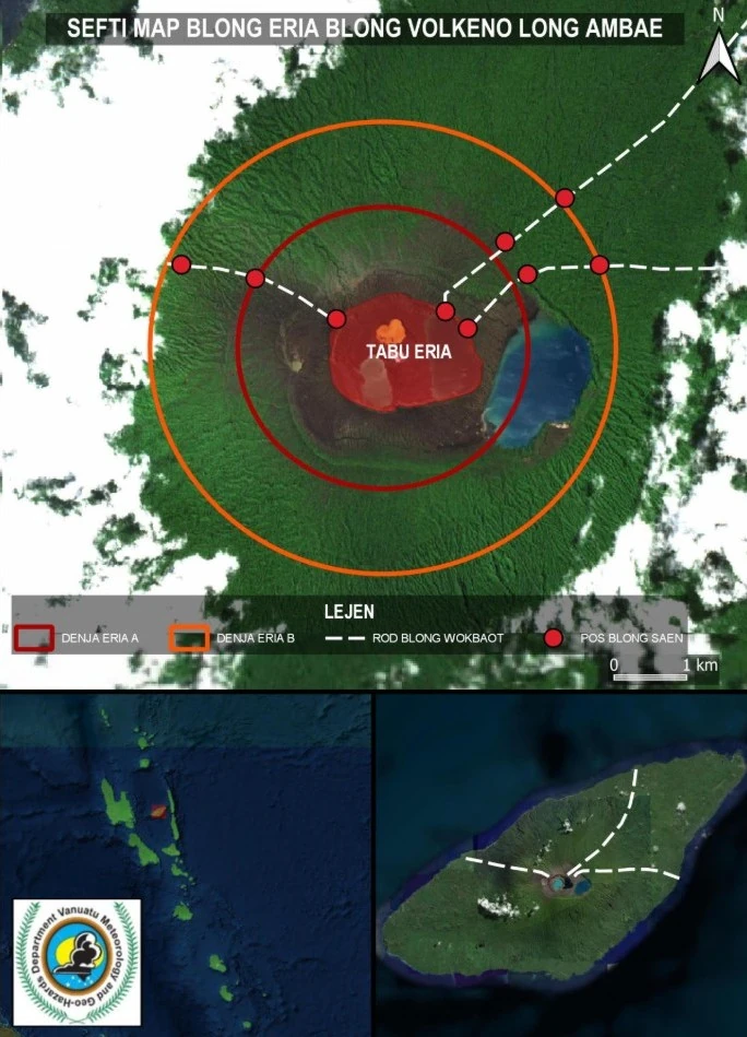
At that time, the designated hazard zone extended 2 km (1.2 miles) from the active vents.
On February 25, the Vanuatu Meteorology and Geo-Hazards Department (VMGD) raised the Ambae Volcanic Alert Level to Level 3, indicating a minor eruption state. The hazard area was expanded to 3 km (1.9 miles) around the active vent within Lake Voui, formally designated as Danger Zone B. Volcanic activity remains confined to the summit caldera.
Since approximately February 20, the volcano has entered a phase of sustained ash and volcanic sand emissions. Satellite instruments detected very high to extremely high sulfur dioxide concentrations during late February, indicating ongoing magma degassing beneath the crater lake system. Thermal monitoring recorded moderate to high anomalies at the summit during the escalation phase.
Ashfall has been reported primarily in the southern and southeastern parts of Ambae Island and may affect nearby Maewo Island depending on prevailing trade winds. Volcanic ash poses risks to respiratory health, infrastructure, agriculture, and water supply systems. Elevated sulfur dioxide emissions may also increase the likelihood of acid deposition in areas experiencing rainfall, particularly in summit and downwind communities.
Authorities have warned that heavy rainfall can remobilize accumulated ash into streams and drainages, increasing the risk of lahars and sudden changes in water flow. Entry into the 3 km (1.8 miles) hazard zone remains prohibited due to the risk of ballistic ejecta, high gas concentrations, dense ash emissions, and reduced visibility near the vent.
Ambae is a large basaltic shield volcano forming the island of the same name. Current plume heights of 4 300–4 900 m (14 000–16 000 feet) remain substantially lower than those recorded during the 2017–2018 eruption, when ash columns exceeded 10 km (6.2 miles) above sea level and prompted large-scale evacuations. No widespread evacuation has been reported during the present eruptive phase.
Monitoring continues using seismic networks, webcam observations, gas measurements, satellite imagery, and aviation advisory systems. Alert Level 3 remains in effect, with activity confined to Lake Voui and hazards limited to Danger Zone B.

I’m a science journalist and researcher at The Watchers, contributing to the Epicenter edition, where I cover peer-reviewed scientific research and emerging discoveries across Earth and space sciences. With a background in astronomy and a passion for environmental science, I’ve worked in shark and coral conservation in Fiji, conducting reef and shark-behavior research, contributing to mangrove restoration, and earning PADI Open Water and Coral Reef Certifications. I bring a blend of scientific rigor and storytelling to illuminate the discoveries shaping our planet and beyond.
Commenting rules and guidelines
We value the thoughts and opinions of our readers and welcome healthy discussions on our website. In order to maintain a respectful and positive community, we ask that all commenters follow these rules.