
Major winter storm brings blizzard conditions to Northern Plains and Great Lakes
A major winter storm is affecting the Northern Plains and the western Great Lakes in the United States on March 15–16, 2026, bringing heavy snowfall, strong winds, and widespread blizzard conditions. Snowfall rates of up to 7.5 cm (3 inches) per hour and wind gusts of up to 95 km/h (60 mph) are forecast across parts of eastern South Dakota, Wisconsin, and Michigan as a strengthening low-pressure system moves toward southeastern Canada. Travel conditions are expected to become extremely dangerous across the affected region.
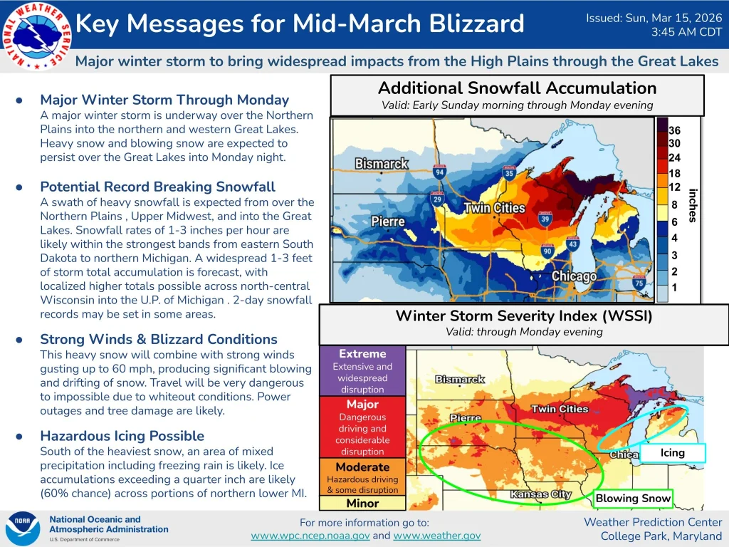
A rapidly intensifying low-pressure system over the central Plains is moving northeast toward Lower Michigan on March 15, producing heavy snow across the Northern Plains, the Upper Midwest, and the Great Lakes.
The system is drawing cold Arctic air into the region while transporting moisture northward, creating conditions favorable for widespread snowfall and blizzard conditions.
Blizzard Warnings are in effect from eastern South Dakota across the Upper Midwest and into the upper Great Lakes. The most severe conditions are forecast in northeastern Wisconsin and the Upper Peninsula of Michigan, where strong winds combined with heavy snowfall are expected to significantly reduce visibility.
Snowfall rates of 2.5–7.5 cm (1–3 inches) per hour are forecast from eastern South Dakota into northern Michigan as the storm intensifies and spreads eastward.
Snow accumulations of 30–90 cm (12–36 inches) are forecast across parts of the Northern Plains, the Upper Midwest, and the Great Lakes between March 15 and 16.
Locally higher accumulations are forecast from Wisconsin to the Upper Peninsula of Michigan, where snowfall totals may exceed 60 cm (24 inches) in some areas and potentially break two-day accumulation records.
Strong winds accompanying the storm are expected to reach up to 95 km/h (60 mph), producing widespread blowing and drifting snow. These conditions are likely to create blizzard and whiteout conditions across affected areas, making travel extremely hazardous.
South of the storm’s center, warmer air is expected to produce mixed precipitation, including freezing rain. Forecasters indicate a greater than 60 percent probability of ice accumulation reaching 6 mm (0.25 inches) in parts of northern and Lower Michigan.
Lake-effect snow is forecast to continue around portions of the Great Lakes through March 17 as cold air flows across the relatively warmer lake waters, prolonging snowfall across downwind areas.
References:
1Short Range Forecast Discussion – NWS – March 15, 2026
Featured image: Heavy snow creates dangerous driving conditions in the Twin Cities, MN – March 2026. Credit: Storm Chasing Video (stillshot)

I am an Assistant Editor and Severe Weather & Science Journalist at The Watchers, specializing in real-time severe weather coverage, geophysical event reporting, and research-driven scientific analysis. You can reach me at rishav(at)watchers(.)news.
Commenting rules and guidelines
We value the thoughts and opinions of our readers and welcome healthy discussions on our website. In order to maintain a respectful and positive community, we ask that all commenters follow these rules.