
Destructive Hurricane “Irma” moving through Florida, toward Georgia
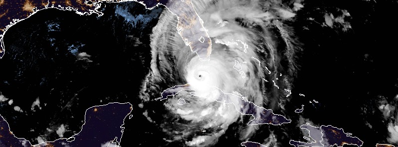
Featured image: Hurricane "Irma" at 05:00 UTC on September 10, 2017. Credit: NOAA/GOES-16 (preliminary and non-operational)
After striking northern Cuba on Saturday, September 9, 2017, Hurricane “Irma” turned toward Florida and regained Category 4 hurricane strength. This extremely dangerous hurricane made landfall at Cudjoe Key in lower Florida Keys at 13:10 UTC (09:10 EDT) on September 10, 2017, with maximum sustained winds of 215 km/h (130 mph).
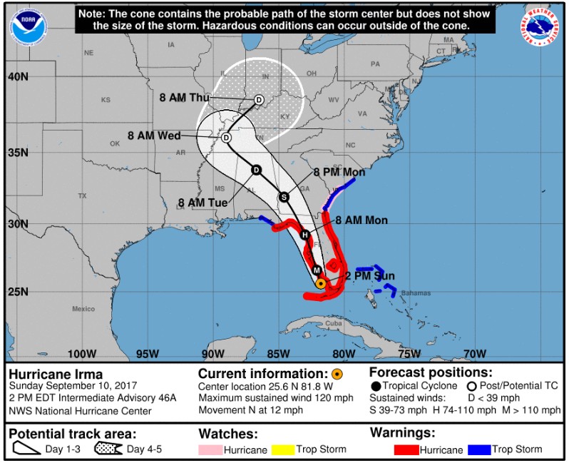
At 07:00 UTC (03:00 EDT) on September 10, 2017, the center of Hurricane “Irma” was located 105 km (65 miles) SE of Key West, Florida. The system has maximum sustained winds of 210 km/h (130 mph), making it a Category 4 hurricane on the Saffir-Simpson scale.
Irma’s minimum central pressure is now 930 hPa. This is the same pressure as Hurricane “Donna” of 1960 when it made landfall in southwest Florida 57 years ago today and the same as the pressure at landfall for the Great Miami Hurricane of 1926.
Irma is moving slowly northwestward toward the lower Florida Keys near 9 km/h (6 mph). A turn toward the north-northwest with an increase in forward speed expected through late Monday.
On the current forecast track, the center of Irma is expected to cross the Lower Florida Keys during the next several hours, and then move near or along the west coast of Florida this afternoon through Monday morning (local time). Irma should then move inland over the Florida panhandle and southwestern Georgia Monday afternoon.
Irma is forecast to restrengthen a little more while it moves through the Straits of Florida and remain a powerful hurricane as it approaches the Florida Keys and the west coast of Florida.
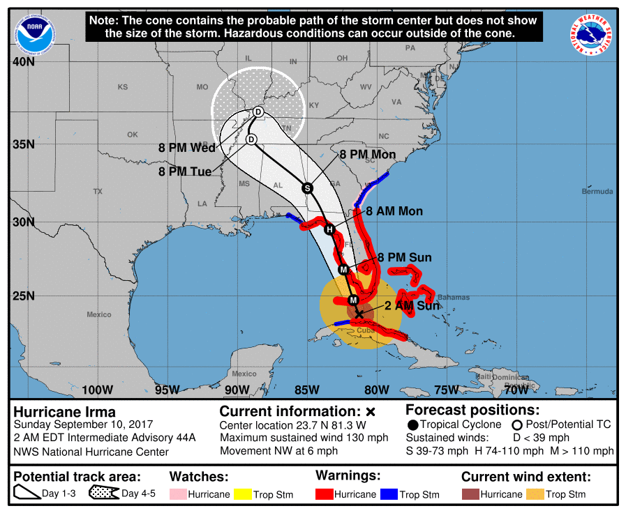
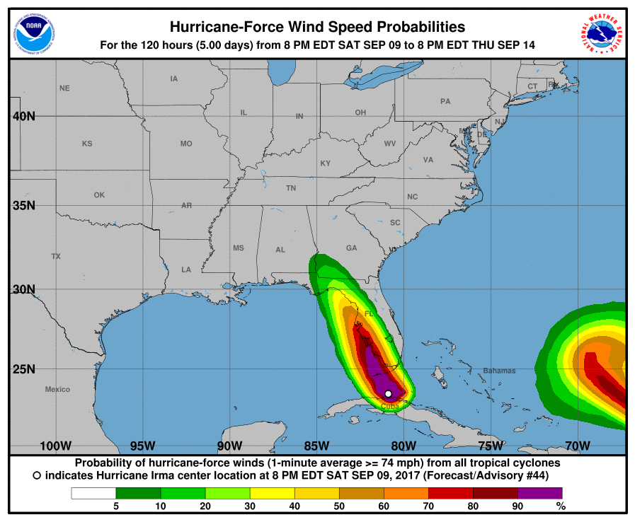
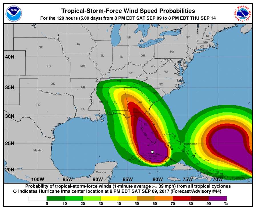
Hurricane-force winds extend outward up to 110 km (70 miles) from the center, and tropical-storm-force winds extend outward up to 335 km (205 miles). A private anemometer at Marathon Key, Florida, recently reported a wind gust of 141 km/h (88 mph).
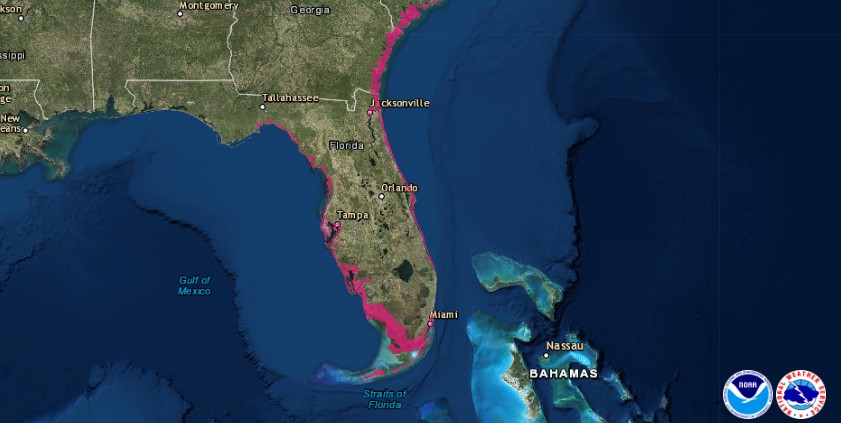
A Storm Surge Warning is in effect for:
- South Santee River southward to Jupiter Inlet
- North Miami Beach southward around the Florida peninsula to the Ochlockonee River
- Florida Keys
- Tampa Bay
A Storm Surge Warning means there is a danger of life-threatening inundation, from rising water moving inland from the coastline, during the next 36 hours in the indicated locations. This is a life-threatening situation. Persons located within these areas should take all necessary actions to protect life and property from rising water and the potential for other dangerous conditions. Promptly follow evacuation and other instructions from local officials.
A Hurricane Warning is in effect for:
- Fernandina Beach southward around the Florida peninsula to Indian Pass
- Florida Keys
- Lake Okeechobee
- Florida Bay
- Cuban provinces of Ciego de Avila, Sancti Spiritus, Villa Clara, Matanzas, and La Habana
- Andros Island, Bimini, and Grand Bahama
A Hurricane Warning means that hurricane conditions are expected somewhere within the warning area. Preparations to protect life and property should be rushed to completion.
A Hurricane Watch is in effect for:
- North of Fernandina Beach to Edisto Beach
A Hurricane Watch means that hurricane conditions are possible within the watch area. A watch is typically issued 48 hours before the anticipated first occurrence of tropical-storm-force winds, conditions that make outside preparations difficult or dangerous.
A Tropical Storm Warning is in effect for:
- West of Indian Pass to the Okaloosa/Walton County Line
- North of Fernandina Beach to South Santee River
A Tropical Storm Warning means that tropical storm conditions are expected somewhere within the warning area.
Hazards affecting land
Storm surge
The combination of a dangerous storm surge and the tide will cause normally dry areas near the coast to be flooded by rising waters moving inland from the shoreline. The water is expected to reach the following HEIGHTS ABOVE GROUND if the peak surge occurs at the time of high tide…
- Cape Sable to Captiva: 3 to 4.6 m (10 to 15 feet)
- Captiva to Ana Maria Island: 1.8 to 3 m (6 to 10 feet)
- Card Sound Bridge through Cape Sable, including the Florida Keys: 1.5 to 3 m (5 to 10 feet)
- Ana Maria Island to Clearwater Beach, including Tampa Bay: 1.5 to 2.4 (5 to 8 feet)
- North Miami Beach to Card Sound Bridge, including Biscayne Bay: 0.9 to 1.5 m (3 to 5 feet)
- South Santee River to Fernandina Beach: 1.2 to 1.8 m (4 to 6 feet)
- Clearwater Beach to Ochlockonee River: 1.2 to 1.8 m (4 to 6 feet)
- Fernandina Beach to Jupiter Inlet: 0.6 to 1.2 m (2 to 4 feet)
- North of North Miami Beach to Jupiter Inlet: 0.3 to 0.6 m (1 to 2 feet)
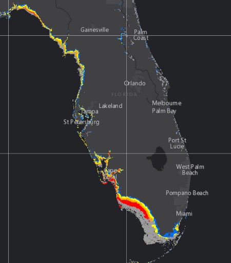
*Displayed flooding values indicate the water height that has about a 1-in-10 (10%) chance of being exceeded.
The deepest water will occur along the immediate coast in areas of onshore winds, where the surge will be accompanied by large and destructive waves. Surge-related flooding depends on the relative timing of the surge and the tidal cycle, and can vary greatly over short distances.
The combination of a life-threatening storm surge and large breaking waves will raise water levels ABOVE NORMAL TIDE LEVELS by the following amounts within the hurricane warning area near and to the north of the center of Irma. Near the coast, the surge will be accompanied by large and destructive waves.
- Northwestern Bahamas: 0.9 to 1.8 m (3 to 6 feet)
- Northern coast of Cuba in the warning area: 1.5 to 3 m (5 to 10 feet)
Wind
Hurricane conditions are expected to continue within the hurricane warning area along the north coast of Cuba through this morning. Hurricane conditions are expected in portions of the Florida peninsula and the Florida Keys beginning in the next several hours, and in the northwestern Bahamas for the next few hours. Tropical storm and hurricane conditions are expected to spread northward across the remainder of the warning areas through Monday.
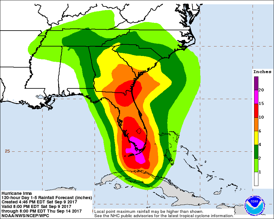
Rainfall
Irma is expected to produce the following rain accumulations through Wednesday:
- Northern Cuba: 254 to 381 mm (10 to 15 inches), isolated 508 mm (20 inches).
- Southern Cuba: 127 to 254 mm (5 to 10 inches), isolated 381 mm (15 inches).
- Western Bahamas: 76.2 to 152.4 mm (3 to 6 inches), isolated 254 mm (10 inches).
- The Florida Keys: 254 to 508 mm (10 to 20 inches), isolated 635 mm (25 inches).
- The Florida peninsula and southeast Georgia: 203.2 to 381 mm (8 to 15 inches), isolated 508 mm (20 inches).
- The eastern Florida Panhandle and southern South Carolina: 101.6 to 203.2 mm (4 to 8 inches), isolated 254 mm (10 inches).
- Rest of eastern Georgia, western South Carolina, and western North Carolina: 101.6 to 203.2 mm (4 to 8 inches).
- Western Georgia, eastern and northern Alabama, and southern Tennessee: 50.8 to 127 mm (2 to 5 inches).
In all areas this rainfall may cause life-threatening flash floods and, in some areas, mudslides.
A few tornadoes are possible through Sunday night, mainly across southern, central, and eastern portions of the Florida peninsula.
The eye
Do not venture outside when the calm eye of the hurricane passes over, as dangerous winds will return very quickly when the eye moves away.
Surf
Swells generated by Irma are affecting the southeast coast of the United States. These swells are likely to cause life-threatening surf and rip current conditions.
Updates
12:00 UTC
The eye of Hurricane “Irma” is 30 km (20 miles) ESE of Key West. Its maximum sustained winds are 215 km/h (130 mph).
More than 850 000 people in Florida are without power.
13:10 UTC
Irma made landfall at Cudjoe Key in Lower Florida Keys at 13:10 UTC (09:10 EDT), according to NHC.
At 13:10 UTC the center of Hurricane “Irma” was located 30 km (20 miles) ENE of Key West, Florida. Its maximum sustained winds were 215 km/h (130 mph).
Irma is moving NNW at 13 km/h (8 mph) with the minimum estimated central pressure of 929 hPa.
18:56 UTC
Irma is impacting all of South Florida for the past two hours.
At 18:00 UTC (14:00 EDT), its eye was located 55 km (35 miles) south of Naples and 115 km (70 miles) south of Ft. Myers. Its maximum sustained winds are currently 195 km/h (120 mph), making it a Category 3 hurricane on the Saffir-Simpson Scale. Irma is moving N at 19 km/h (12 mph) with the minimum estimated central pressure of 936 hPa.
On the forecast track, the center of Irma should move near or over the southwest and west coast of the Florida Peninsula later today (local time) through tonight. It should then move inland over northern Florida and southwestern Georgia Monday afternoon.
September 11
06:00 UTC
At least 3.5 million people across Florida are without power.
A historic warning – first-ever Tropical Storm Warning – was issued for Atlanta. Governor Nathan Deal has expanded an emergency declaration to include all 159 counties in Georgia.
The center of Hurricane “Irma” is located 30 km (20 miles) NW of Lakeland and 40 km (25 miles) NE of Tampa. Its maximum sustained winds, at 06:00 UTC, are 135 km/h (85 mph) and minimum central pressure 960 hPa.
Irma is moving NNW at 24 km/h (15 mph).
A turn toward the northwest at a faster forward speed is expected during the next day or so. On the forecast track, the center of Irma will continue to move over the western Florida peninsula through this morning and then into the southeastern United States late today and Tuesday.
Additional weakening is forecast, and Irma is expected to become a tropical storm over far northern Florida or southern Georgia later today.
Irma has a very large wind field. Hurricane-force winds extend outward up to 130 km (80 miles) from the center, and tropical-storm-force winds extend outward up to 665 km (415 miles).
12:00 UTC
Irma weakened to a tropical storm but is still producing some wind gusts to near hurricane force.
At 12:00 UTC, its center was located about 50 km (30 miles) NNE of Cedar Key and 170 km (105 miles) NNW of Tampa. Its maximum sustained winds are 110 km/h (70 mph) and minimum central pressure 970 hPa.
Irma is moving NNW at 30 km/h (18 mph).
21:00 UTC
The center of Tropical Storm “Irma” is moving through Georgia and is expected to continue moving through the state tonight (local time) and move into Alabama on Tuesday, September 12.
22:40 UTC
Irma is now blamed for the deaths of 7 people in the United States, 10 in Cuba, 11 in St Martin-St Maarten-St Barth, 1 in Anguilla and 4 in the British Virgin Islands.
Some 6.3 million people in Florida are without power and almost 1.3 million in Georgia.
September 12
Irma has degenerated into a remnant low.
It is now blamed for the deaths of 22 people in the United States.
I'm a dedicated researcher, journalist, and editor at The Watchers. With over 20 years of experience in the media industry, I specialize in hard science news, focusing on extreme weather, seismic and volcanic activity, space weather, and astronomy, including near-Earth objects and planetary defense strategies. You can reach me at teo /at/ watchers.news.
Commenting rules and guidelines
We value the thoughts and opinions of our readers and welcome healthy discussions on our website. In order to maintain a respectful and positive community, we ask that all commenters follow these rules.