
Myanmar braces for Tropical Cyclone “Maarutha”
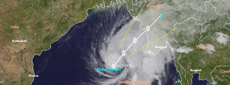
Featured image: Tropical Cyclone 01B (Maarutha), April 15, 2017. Credit: UW-CIMSS
A depression in the Bay of Bengal has intensified into a deep depression (01B) and is moving toward Myanmar at a speed of 28 km/h (17.4 mph). The system is expected to become the first named storm of the 2017 North Indian Ocean Cyclone Season, a full month earlier than the first storm of the past season. Landfall is expected on April 17.
At 09:00 UTC (14:30 IST) on April 15, 2017, the center of this system was located over east-central Bay of Bengal, about 350 km (217.5 miles) west-northwest of Maya Bandar, Andaman and Nicobar Islands and 740 km (460 miles) south-southwest of Kyaukpyu, Myanmar, according to RSMC New Delhi, WMO authority for this part of the world.
The center said it expects the system to intensify further into a cyclonic storm by 18:00 UTC (23:30 IST) today. When it does, it will be named Cyclone "Maarutha."
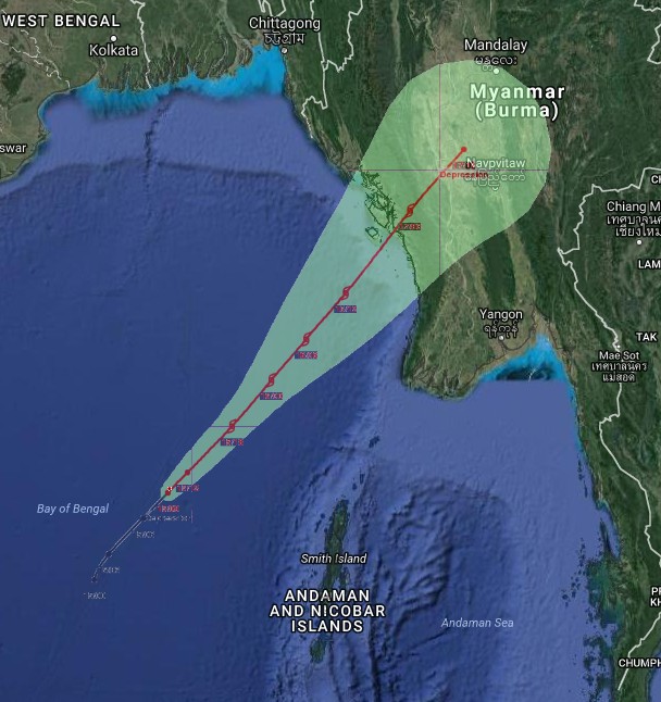
Credit: RSMC New Delhi/Google
Maarutha is most likely to move north-northeastwards, weaken back to deep depression and make landfall over Myanmar coast between Sittwe and Sandway by the morning of April 17 (local time).
The center has issued the following warnings:
- Heavy Rainfall Warning: Rainfall at most places with heavy rainfall at isolated places very likely to occur over Andaman Islands during next 24 hrs and isolated heavy rainfalls during subsequent 24 hours.
- Wind warning: Squally winds speed reaching 50 – 60 km/h (31 – 37 mph) gusting to 70 km/h (43 mph) would prevail over Andaman Islands and adjoining sea areas during next 48 hours.
- Sea condition: Sea condition would be very rough along and off Andaman Islands during next 36 hours.
- Fishermen Warning: Fishermen are advised not to venture into sea along and off Andaman Islands during next 48 hrs. Fishermen out at sea are advised to return to the coast
At 15:00 UTC on April 15, JTWC said the center of Tropical Cyclone 01B was located 1 044 km (650 miles) south of Dhaka, Bangladesh, and has tracked northeastward at 24 km/h (15 mph) over the past 6 hours.
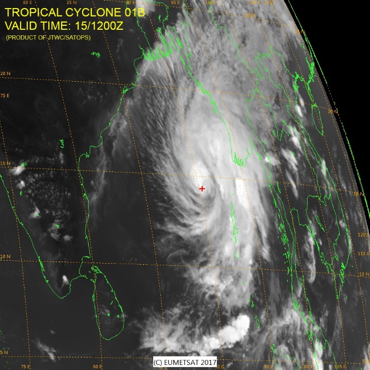
Credit: JTWC/SATOPS, EUMETSAT
Animated multispectral satellite imagery depicts a rapidly consolidating system with formative banding wrapping into the low level circulation center. Environmental analysis shows favorable conditions with an excellent poleward outflow channel feeding into the midlatitude trough and very warm sea surface temperatures.
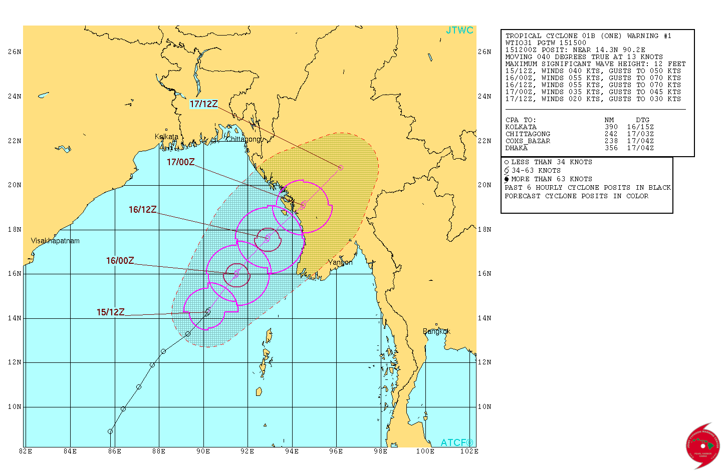
Tropical Cyclone 01B (Maarutha) JTWC forecast track on April 15, 2017
JTWC expects steady intensification over the next 24 hours as the system tracks to the northeast reaching a peak intensity of 101 km/h (63 mph). Landfall is expected just before 03:00 UTC on April 17.
I'm a dedicated researcher, journalist, and editor at The Watchers. With over 20 years of experience in the media industry, I specialize in hard science news, focusing on extreme weather, seismic and volcanic activity, space weather, and astronomy, including near-Earth objects and planetary defense strategies. You can reach me at teo /at/ watchers.news.
Commenting rules and guidelines
We value the thoughts and opinions of our readers and welcome healthy discussions on our website. In order to maintain a respectful and positive community, we ask that all commenters follow these rules.