
Seismologists analyze Myanmar’s devastating M7.7 earthquake
An M7.7 earthquake struck near Mandalay, Myanmar, on March 28, 2025, killing more than 5 000 people and injuring at least 11 400. The shallow, high-magnitude event ruptured a long section of the Sagaing Fault, prompting seismologists to investigate its complex rupture dynamics and evidence of supershear propagation.
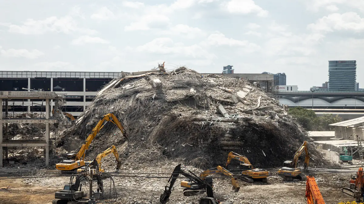
Collapse of New Headquarters of the State Audit Office (Thailand) after the 2025 Myanmar earthquake, pictured from JJ Mall, Bangkok. Image credit: Supanut Arunoprayote
A powerful M7.7 earthquake struck 16 km (10 miles) northwest of Sagaing, near Mandalay, Myanmar, on March 28, 2025, at 12:50 local time (06:20 UTC). The shallow strike-slip event occurred at a depth of approximately 10 km (6 miles) along the Sagaing Fault and was the strongest instrumentally recorded earthquake in Myanmar since 1912. It caused widespread damage across central Myanmar, northern Thailand, southern China, and parts of Vietnam.
The earthquake caused more than 5 000 fatalities in Myanmar, 51 in Thailand, and one in Vietnam, reportedly due to cardiac shock
At least 11 400 people were injured, and hundreds remain missing, including workers trapped at a construction site that collapsed in Bangkok. Extensive infrastructure damage was reported, particularly in Mandalay and Sagaing, where buildings, bridges, and dams sustained severe structural impacts.
Seismologists reported that the Sagaing fault, a major tectonic boundary, ruptured over 400 km (250 miles). This rupture, among the largest globally, exhibited a “supershear” speed, traveling faster than the speed of sound following an initial slow phase. Ground shaking extended over 100 km (62 miles), with Modified Mercalli Intensity levels exceeding VIII in multiple regions.
According to the U.S. Geological Survey (USGS), the earthquake’s shallow depth amplified ground shaking across the region, contributing to widespread structural damage. Liquefaction—where saturated soil temporarily loses strength and behaves like a liquid—was observed in multiple locations, further intensifying damage. An M6.4 aftershock struck 12 minutes later, and continued seismic activity in the following days has sustained concerns about regional stability and secondary hazards.
Researchers from Johns Hopkins University and the USGS used satellite imagery to map the surface rupture and assess structural damage in Mandalay. This rapid geospatial analysis supported emergency response teams by identifying the most severely affected areas and demonstrated the increasing role of satellite data in real-time assessment of earthquake damage.
For the first time during a large-magnitude earthquake, a submarine telecommunication cable network equipped with more than 100 seismic sensors detected ground motion in real time. According to Mikael Mazur of Nokia Bell Labs, the system provided continuous seismic data during the event, offering valuable insights into offshore ground motion.
This integration of seismic sensing into undersea infrastructure represents a step forward in expanding global earthquake monitoring capabilities, particularly in regions with limited land-based instrumentation.
At the Seismological Society of America’s Annual Meeting on April 15 in Baltimore, researchers presented preliminary analyses of the rupture. The earthquake occurred within a seismic gap that had remained inactive since 1839, located between the rupture zones of the 1929 Naypyidaw and 1956 southern Sagaing earthquakes. The spatial overlap with previous events highlights the structural complexity of the Sagaing Fault system.
Ground motion studies led by Hiroshi Kawase and colleagues since 2014 have provided detailed data on local site conditions in cities such as Sagaing and Yangon. Their findings help explain the amplified shaking observed in distant regions like Bangkok, where shallow sedimentary layers contributed to increased ground motion. This research supports more accurate seismic hazard assessments in urban areas across Southeast Asia.
In Thailand, the earthquake caused severe ground shaking, leading to substantial damage and casualties. A 33-story building under construction in Bangkok’s Chatuchak district collapsed, resulting in at least 47 fatalities and 53 individuals reported missing. The disaster prompted Thai authorities to declare a state of emergency in Bangkok and other affected regions.

In China’s Yunnan Province, the earthquake resulted in the damage of approximately 847 homes, affecting around 2,840 individuals. Two people sustained injuries in the border city of Ruili. Chinese authorities have deployed rescue teams and are providing assistance to those impacted by the disaster.
In Vietnam, the earthquake’s tremors were felt in Ho Chi Minh City, causing damage to over 400 apartments. One person died from shock during evacuation efforts.
Myanmar’s ongoing humanitarian crisis—affecting more than 20 million people and displacing 3.5 million—is complicating emergency response operations. Following the earthquake, the military government declared central Myanmar a disaster zone and formally requested international assistance.
References:
1 Seismologists Share Early Analyses of Myanmar Earthquake – Seismological Society of America – April 15, 2025
2 Over 4 400 dead after deadliest earthquake in 95 years strikes Myanmar – The Watchers – March 29, 2025
3 Violent M7.7 earthquake hits Sagaing, Myanmar, leaving over 4 400 fatalities, 5 400 injured and many missing – The Watchers – March 28, 2025

I’m a science journalist and researcher at The Watchers, contributing to the Epicenter edition, where I cover peer-reviewed scientific research and emerging discoveries across Earth and space sciences. With a background in astronomy and a passion for environmental science, I’ve worked in shark and coral conservation in Fiji, conducting reef and shark-behavior research, contributing to mangrove restoration, and earning PADI Open Water and Coral Reef Certifications. I bring a blend of scientific rigor and storytelling to illuminate the discoveries shaping our planet and beyond.
Satellites should be able to give good estimates of how many buildings collapsed, because many countries like to “launder information” to present a palatable view to global viewers or locals. Data like this should not be held ransom.