
Category 4 Typhoon Neoguri aims Okinawa and Japan
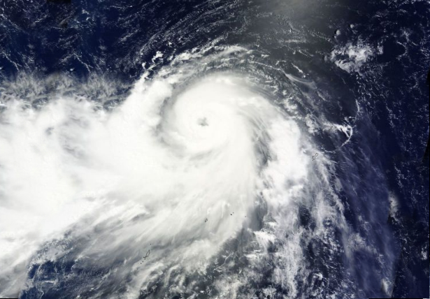
Featured image: Typhoon Neoguri captured by Terra/MODIS satellite on July 5, 2014. (Credit: LANCE Rapid Response/MODIS/WorldView)
Typhoon Neoguri (Florita), the second typhoon of the 2014 Western Pacific season, is on the way to become an extremely dangerous cyclone as it moves northwest over the warm open waters of the western Pacific. Category 4 Typhoon Neoguri is rapidly intensifying and will likely become a super typhoon. Neoguri is the strongest tropical cyclone this year in the Western Pacific basin.
Tropical Storm Neoguri (TW 08W) became Typhoon Neoguri on July 4, 2014. By July 5, the system rapidly intensified into a Category 4 typhoon, reaching wind speed of 210 km/h (130 mph). Currently, Category 4 Typhoon is tracking toward Okinawa and parts of Japan and East Asia. Maximum recorded wind speed on July 5, 2014 was 265 km/h (165 mph).
.jpg)
MTSAT IR satellite image of Typhoon Neoguri taken at 22:30 UTC on July 5, 2014. (Credit: NOAA/UW-CIMS)
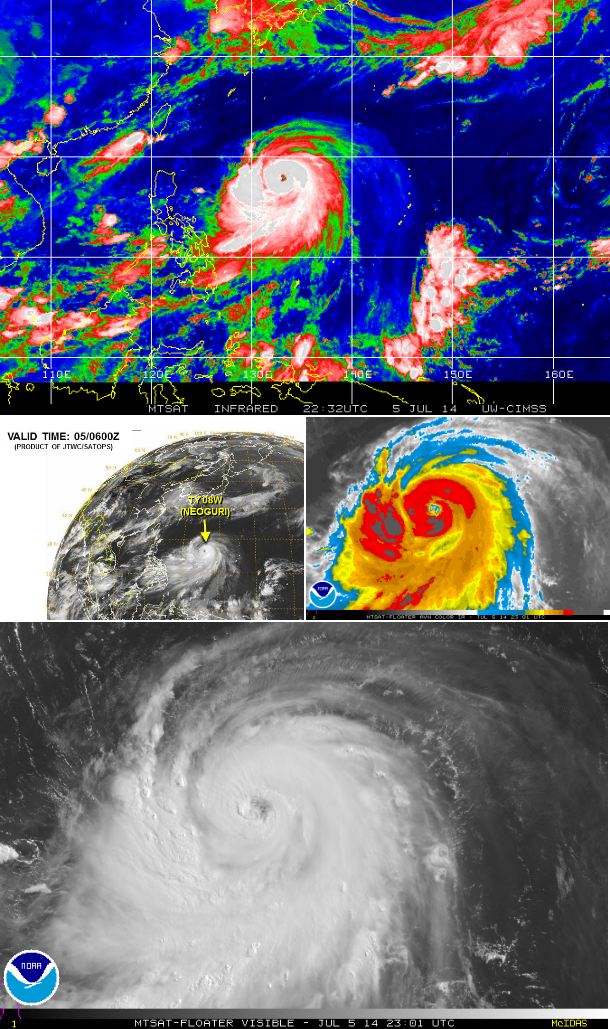
Composite satellite images of Typhoon Neoguri late on July 5, 2014. (Credit: NOAA/JTWC/UW-CIMSS)
Strengthening will continue into early next week as the cyclone progresses through an area of very warm ocean waters and low vertical wind shear. The cyclone is expected to take a more northward direction early next week as it approaches the Ryukyu Islands and then slowly turn toward the northeast and approach southern Japan by July 8, 2014. Neoguri could make landfall in Kyushu with strong winds, high waves and heavy rains across the region. The Japan Meteorological Agency has already issued Typhoon Warnings for the southern Japanese islands and expects damaging winds.
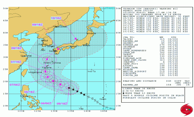
Typhoon Neoguri forecast track (Credit: JTWC)
Neoguri could also influenced southwest monsoon across the Philippines with flooding rainfall possible in west-central and northwest parts of the country. Large storm surge is possible over the southern islands with some locations near the center of the storm seeing a threat for storm surge of over 6 meters (20 feet).
Satellite Animations
- Storm-Centered Infrared (MTSAT2; NOAA/SSD)
- Storm-Centered Infrared (Aviation Color Enhancement) (MTSAT2; NOAA/SSD)
- Storm-Centered Water Vapor (MTSAT2; NOAA/SSD)
- Storm-Centered Visible (MTSAT2; NOAA/SSD)
- Storm-Centered Visible (Colorized) (MTSAT2; NOAA/SSD)
- Storm-Centered Infrared (MTSAT2; CIMSS)
- Storm-Centered Enhanced Infrared (MTSAT2; CIMSS)
- Storm-Centered Water Vapor (MTSAT2; CIMSS)
- Storm-Centered Visible (MTSAT2; CIMSS)
- Tropical West Pacific Infrared (MTSAT2; NOAA)
- Tropical West Pacific Enhanced Infrared (MTSAT2; NOAA)
- Tropical West Pacific Water Vapor (MTSAT2; NOAA)
- Tropical West Pacific Visible (MTSAT2; NOAA)
Commenting rules and guidelines
We value the thoughts and opinions of our readers and welcome healthy discussions on our website. In order to maintain a respectful and positive community, we ask that all commenters follow these rules.