
Arthur becomes post-tropical system

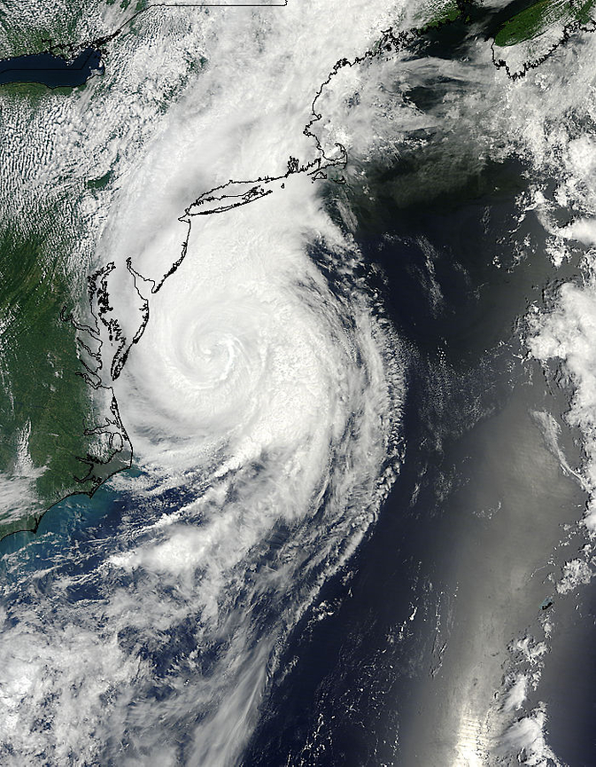
Featured image: Terra/MODIS satellite image of extratropical storm Arthur on July 5, 2014. (Credit: LANCE Rapid Response/MODIS)
Arthur made landfall in Nova Scotia as tropical storm early on July 5, 2014, reaching wind speed of 105 km/h (65 mph). Tropical storm force winds with heavy rainfall were reported across Nantucket and portions of Massachusetts and eastern Maine. Flooding in southeast Massachusetts subsided overnight as Arthur's rainbands moved out.
Severe winds are currently affecting Nova Scotia where wind gusts near 120 km/h (75 mph) have been reported and widespread tree damage has been reported throughout the regions affected. The number of power outages has increased significantly.
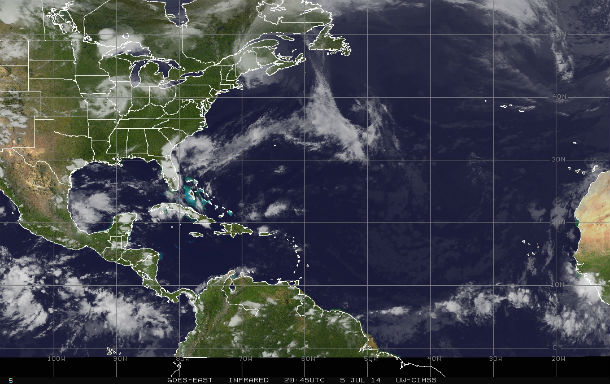
GOES-East IR satellite image of extratropical storm Arthur captured at 20:45 UTC on July 5, 2014. (Credit: NOAA/UW-CIMSS)
According to Canadian Hurricane Centre, large offshore waves of up to 9 meters were reported earlier this morning south of Nova Scotia. Closer to shore 4 to 6 meter waves have been recorded. These large waves will give heavy pounding surf along the Atlantic coast of Nova Scotia and Newfoundland. Rough and pounding surf and rip currents are probable along much of the coast with these waves.
A trough of low pressure and cold front over Canadian Maritimes absorbed Arthur's circulation an weaken the system just before landfall. Twelve hours prior when Arthur was a hurricane, it had a minimum central pressure of 936 millibars.
Risk of rip current and high surf still remain high as the system moves rapidly into the Canadian Maritimes. Strong winds and heavy rain are expected in New Brunswick, Prince Edward Island, and parts of Nova Scotia as Arthur transitions to a strong post-tropical low and moves through.
.png)
Terra/MODIS satellite image of extratropical storm Arthur on July 5, 2014. (Credit: LANCE Rapid Response/MODIS)
Arthur is moving northeastward at speed of 24 mph (40 km/h).
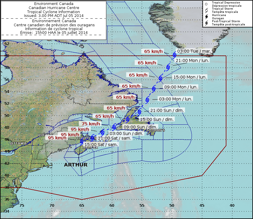
Arthur's forecast track by Canadian Hurricane Centre (Credit: CHC/Environment Canada)
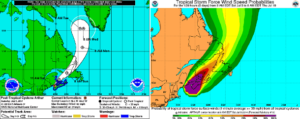
5-day forecast track and tropical storm force wind speed probability maps (Credit: NOAA/NHC)
Hurricane Arthur has become the first hurricane to make landfall in the continental U.S. since Hurricane Isaac in August, 2012. Sandy, in October 2012, became post-tropical shortly before landfall. Arthur is also the first Category 2 hurricane or greater strength to make landfall in the Lower states since Ike, which struck Texas in September, 2008.
Hurricane Arthur made its first landfall over the Shackleford Banks, between Cape Lookout and Beaufort, North Carolina, on July 3, 2014. During July 4, the center of Arthur crossed over the northern Outer Banks of North Carolina near Nags Head. A 4.65 foot storm surge was reported in Oregon Inlet, North Carolina. By evening July 4, 2014 Arthur made its closest approach to New England, near Nantucket and Cape Cod.
MODIS instrument aboard NASA's Terra satellite captured this visible image of Hurricane Arthur on July 4 at 15:20 UTC. Arthur's center was off the coast of Delaware and Maryland. (Credit: NASA Goddard MODIS Rapid Response Team)
Satellite Animations
- Storm-Centered Infrared (GOES 13; NOAA/SSD)
- Storm-Centered Infrared (Aviation Color Enhancement) (GOES 13; NOAA/SSD)
- Storm-Centered Water Vapor (GOES 13; NOAA/SSD)
- Storm-Centered Visible (GOES 13; NOAA/SSD)
- Storm-Centered Visible (Colorized) (GOES 13; NOAA/SSD)
- Storm-Centered Infrared (GOES 13; CIMSS)
- Storm-Centered Enhanced Infrared (GOES 13; CIMSS)
- Storm-Centered Water Vapor (GOES 13; CIMSS)
- Storm-Centered Visible (GOES 13; CIMSS)
- Eastern U.S./West Atlantic Infrared (GOES 13; NOAA/SSD)
- Eastern U.S./West Atlantic Infrared (Aviation Color Enhancement) (GOES 13; NOAA/SSD)
- Eastern U.S./West Atlantic Water Vapor (GOES 13; NOAA/SSD)
- Eastern U.S./West Atlantic Visible (GOES 13; NOAA/SSD)
- Eastern U.S./West Atlantic Visible (Colorized) (GOES 13; NOAA/SSD)
Commenting rules and guidelines
We value the thoughts and opinions of our readers and welcome healthy discussions on our website. In order to maintain a respectful and positive community, we ask that all commenters follow these rules.