
Hurricane “Teddy” forecast to become a strong post-tropical cyclone before reaching Nova Scotia, Canada
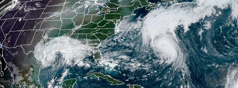
Featured image: Hurricane "Teddy" and Tropical Storm "Beta" at 13:40 UTC on September 21, 2020. Credit: NOAA/GOES-16, RAMMB/CIRA
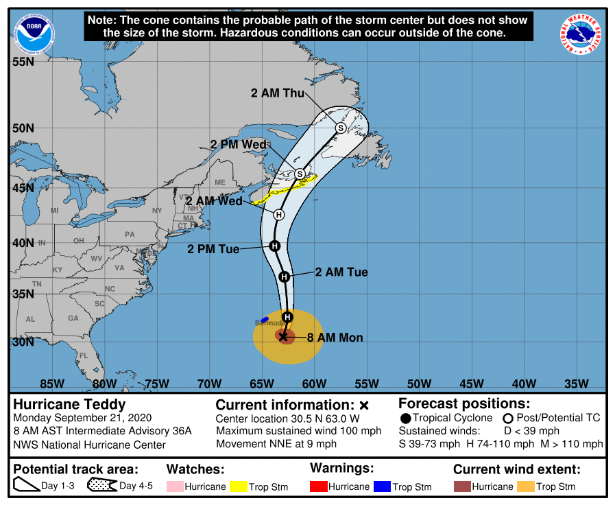
The center of Hurricane "Teddy" is moving east of Bermuda on September 21, 2020, bringing tropical-storm-force wind gusts. Teddy is forecast to become a strong post-tropical cyclone before reaching Nova Scotia, Canada on September 23.
- A Tropical Storm Warning is in effect for Bermuda and Watch for Lower East Pubnico to Main-a-Dieu, Nova Scotia, Canada.
- Gradual weakening is forecast to begin mid-week, but the cyclone is expected to remain a large and powerful hurricane Tuesday, then become a strong post-tropical cyclone when it nears Nova Scotia by Wednesday morning (LT), September 23.
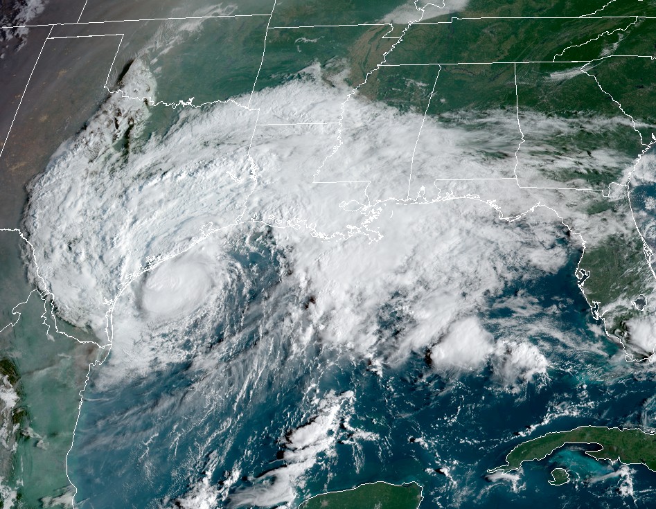
- Meanwhile, the center of Tropical Storm "Beta" will continue to move toward the central coast of Texas and will likely move inland by tonight. Beta is forecast to remain close to the coast of southeastern Texas on Tuesday.
Hurricane "Teddy" is expected to transition to a powerful post-tropical cyclone as it moves near or over portions of Atlantic Canada late Tuesday, September 22 through Thursday, September 24. There is an increasing risk of direct impacts from wind, heavy rain, and storm surge.
At 12:00 UTC on September 21, Teddy's center was located about 260 km (160 miles) SE of Bermuda. The system had maximum sustained winds of 155 km/h (100 mph), making it a Category 2 hurricane on the Saffir-Simpson Hurricane Wind Scale.
Teddy had minimum central pressure of 960 hPa and was moving NNE at 15 km/h (9 mph). Little change in strength is expected during the next day or so, NHC forecasters said.
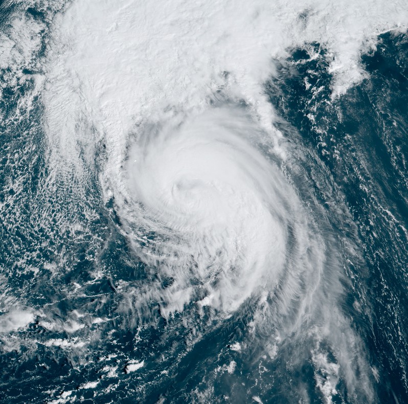
Hurricane "Teddy" at 13:40 UTC on September 21, 2020. Credit: NOAA/GOES-16, RAMMB/CIRA
Gradual weakening is forecast to begin mid-week, but the cyclone is expected to remain a large and powerful hurricane Tuesday, then become a strong post-tropical cyclone when it nears Nova Scotia by Wednesday morning.
Tropical storm conditions could begin over Nova Scotia on Tuesday afternoon (LT).
Large swells generated by Teddy are affecting Bermuda, the Lesser Antilles, the Greater Antilles, the Bahamas, the east coast of the United States, and Atlantic Canada. These swells are likely to cause life-threatening surf and rip current conditions.
From Tuesday through Thursday, Teddy is expected to produce rainfall accumulations of 50 to 100 mm (2 to 4 inches) with isolated totals of 150 mm (6 inches) across sections of Atlantic Canada.
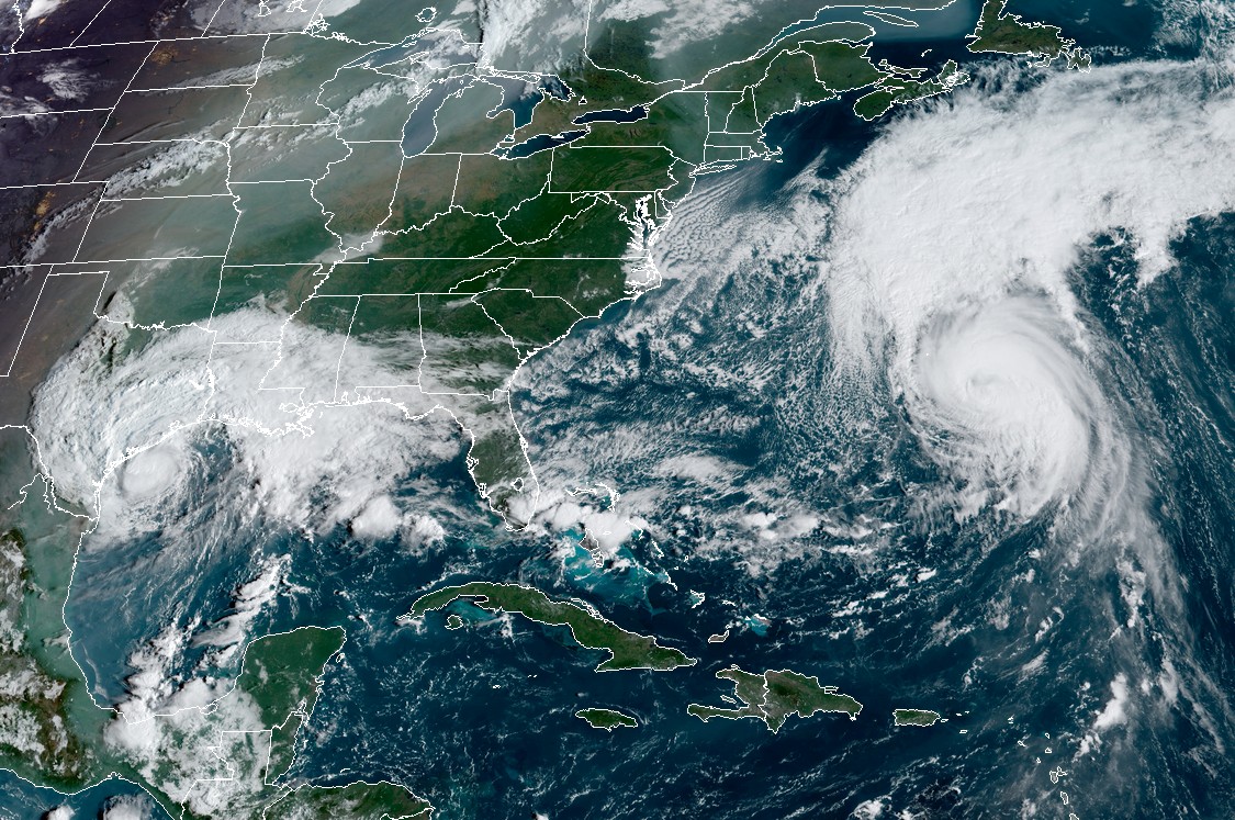
Hurricane "Teddy" and Tropical Storm "Beta" at 13:40 UTC on September 21, 2020. Credit: NOAA/GOES-16, RAMMB/CIRA
Meanwhile, Tropical Storm "Beta" is moving toward the central coast of Texas, with landfall expected by tonight, September 21.
At 12:00 UTC today, Beta's center was located about 110 km (70 miles) SW of Port O'Connor, and 190 km (120 miles) SSW of Galveston, Texas. The storm had maximum sustained winds of 85 km/h (50 mph) and was moving W at 9 km/h (6 mph). It had minimum central pressure of 996 hPa.
A Storm Surge Warning is in effect for Port Aransas, Texas to Rockefeller Wildlife Refuge, Louisiana, including Copano Bay, Aransas Bay, San Antonio Bay, Matagorda Bay, Galveston Bay, Sabine Lake, and Lake Calcasieu.
A Tropical Storm Warning is in effect for Port Aransas Texas to Morgan City Louisiana A Tropical Storm Watch is in effect for Baffin Bay to Port Aransas, Texas.

Tropical Storm "Beta" at 13:40 UTC on September 21, 2020. Credit: NOAA/GOES-16, RAMMB/CIRA
Forecast models
I'm a dedicated researcher, journalist, and editor at The Watchers. With over 20 years of experience in the media industry, I specialize in hard science news, focusing on extreme weather, seismic and volcanic activity, space weather, and astronomy, including near-Earth objects and planetary defense strategies. You can reach me at teo /at/ watchers.news.
Commenting rules and guidelines
We value the thoughts and opinions of our readers and welcome healthy discussions on our website. In order to maintain a respectful and positive community, we ask that all commenters follow these rules.