
Lee forecast to start impacting New England today

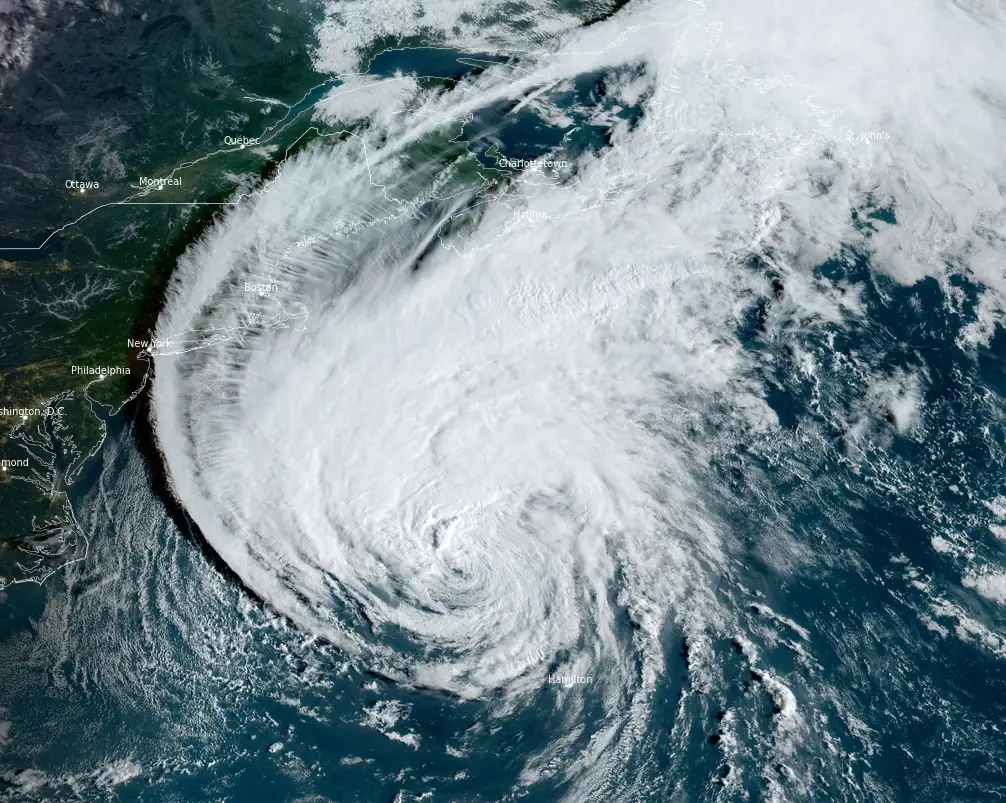
Featured image: Hurricane "Lee" at 12:00 UTC on September 15, 2023. Credit: NOAA/GOES-East, RAMMB/CIRA, The Watchers
As per the National Hurricane Center’s latest advisory at 12:00 UTC (8:00 AM AST) on September 15, 2023, Hurricane Lee, currently over the western Atlantic Ocean, is anticipated to bring tropical storm conditions across parts of coastal New England by this afternoon.
At the time, the center of Lee was located about 740 km (460 miles) SSE of Nantucket, Massachusetts. The system had maximum sustained winds of 140 km/h (85 mph) and was moving N at 26 km/h (16 mph). Its minimum central pressure was 962 hPa.
Alerts and Warnings:
- Hurricane Watch: From Petit Manan Point, Maine to the U.S./Canada border, parts of New Brunswick, and portions of Nova Scotia.
- Tropical Storm Warning: In effect for Bermuda, from Westport Massachusetts extending north to the U.S./Canada border, including Martha’s Vineyard, Nantucket, and parts of New Brunswick and Nova Scotia.
Residents are advised that hurricane conditions could be possible within the next 48 hours in the Hurricane Watch zones, while tropical storm conditions are expected in the Tropical Storm Warning areas within 36 hours.
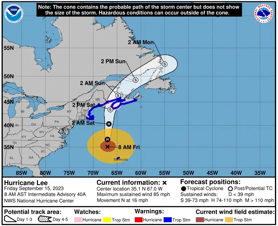
Lee is expected to approach the coast of New England and Atlantic Canada today and tomorrow. By Saturday night and Sunday, the hurricane is predicted to sweep across Atlantic Canada, shifting in a north-northeast and then northeast direction.
Despite the forecast indicating that Lee will turn post-tropical and start weakening by Saturday, it is likely to remain a substantial threat when it hits eastern New England and Atlantic Canada.
Potential hazards:
- Winds: Tropical storm conditions will continue on Bermuda through this morning, and hurricane conditions are a potential threat in Maine and Atlantic Canada by Saturday.
- Surf: Lee-generated swells could pose life-threatening surf and rip current conditions in areas ranging from the Lesser Antilles to Atlantic Canada.
- Rainfall: Expected to range between 25 to 100 mm (1 – 4 inches) across parts of eastern New England, New Brunswick, and Nova Scotia, potentially leading to localized flooding.
- Storm surge: Coastal areas from Flushing, NY to the U.S./Canada border could witness a surge of 1-3 feet, with accompanying large, destructive waves.
References:
1 Hurricane Lee – Intermediate Advisory Number 40A – NWS National Hurricane Center Miami FL – 800 AM AST Fri Sep 15 2023
The Watchers team and our contributors bring the latest on extreme weather, earthquakes, volcanic eruptions, space weather, and all things science. We're all about making sense of the natural world and keeping you informed on what’s happening. Got a tip or a question? Hit us up using the form at newstips!
Commenting rules and guidelines
We value the thoughts and opinions of our readers and welcome healthy discussions on our website. In order to maintain a respectful and positive community, we ask that all commenters follow these rules.