
Tropical storm developing off the SE coast of USA, landfall forecast in North Carolina
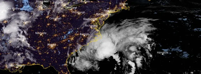
Image credit: NOAA GOES-East, RAMMB/CIRA, The Watchers. Acquired at 08:10 UTC on September 22, 2023
Meteorologists are closely monitoring a low-pressure system currently situated off the southeastern coast of the United States. Currently known as Potential Tropical Cyclone Sixteen, the system is expected to strengthen into a full-fledged tropical storm by the time it makes landfall in North Carolina on Saturday, September 23, 2023.
- Heavy rainfall from this system could produce localized urban and small stream flooding impacts across the eastern mid-Atlantic states from North Carolina to New Jersey Friday through Sunday.
- Swells generated by this system will affect much of the U.S. east coast through the weekend, likely causing life-threatening surf and rip currents.
According to the National Weather Service (NWS), Tropical Storm Warnings are in effect along a stretch of coast ranging from Cape Fear, North Carolina, to Fenwick Island, Delaware. In addition, Storm Surge Warnings have been issued for specific areas including Pamlico and Albemarle Sounds, as well as the lower Chesapeake Bay.
At 09:00 UTC on September 22, the center of Potential Tropical Cyclone Sixteen was located about 530 km (330 miles) ESE of Charleston, South Carolina and 525 km (325 miles) S of Cape Hatteras, North Carolina.
The system had maximum sustained winds of 85 km/h (50 mph), minimum central pressure of 1 000 hPa (29.53 inches), and was moving N at 22 km/h (14 mph).
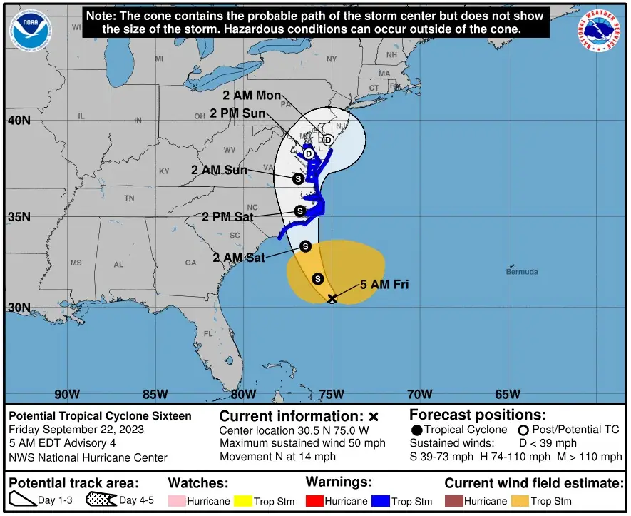
Additional strengthening is forecast during the next day or so, and the low is expected to become a tropical storm before it reaches the coast of North Carolina. Regardless of whether it becomes a tropical storm, the system is expected to bring tropical-storm conditions to portions of the southeast and mid-Atlantic coasts.
The combination of a dangerous storm surge and the tide will cause normally dry areas near the coast to be flooded by rising waters moving inland from the shoreline, the National Hurricane Center (NHC) warns.
The water could reach the following heights above ground somewhere in the indicated areas if the peak surge occurs at the time of high tide:
- Neuse and Bay Rivers: 0.9 – 1.5 m (3 – 5 feet)
- Pamlico and Pungo Rivers: 0.9 – 1.5 m (3 – 5 feet)
- Chesapeake Bay south of Colonial Beach: 0.6 – 1.2 m (2 – 4 feet)
- Surf City NC, NC to Chincoteague, VA: 0.6 – 1.2 m (2 – 4 feet)
- Albemarle Sound: 0.6 – 1.2 m (2 – 4 feet)
- South Santee River, SC to Surf City NC, NC: 0.3 – 0.9 m (1 – 3 feet)
- Chincoteague, VA to Manasquan Inlet, NJ: 0.3 – 0.9 m (1 – 3 feet)
- Upper Chesapeake Bay: 0.3 – 0.9 m (1 – 3 feet)
- Delaware Bay: 0.3 – 0.9 m (1 – 3 feet)
The deepest water will occur along the immediate coast in areas of onshore winds, where the surge will be accompanied by dangerous waves. Surge-related flooding depends on the relative timing of the surge and the tidal cycle, and can vary greatly over short distances. For information specific to your area, please see products issued by your local National Weather Service forecast office.
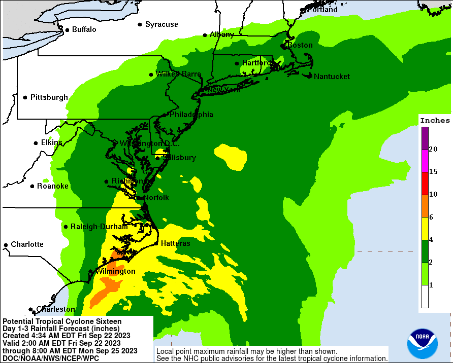
The system is forecast to produce 76 mm (3 inches) to 127 mm (5 inches) of rainfall, with localized amounts of 178 mm (7 inches), across eastern North Carolina into southeast Virginia into Saturday. Across remaining portions of the Mid-Atlantic into southern New England, 51 mm (2 inches) to 102 mm (4 inches) of rainfall are forecast from late today into Sunday. This rainfall may produce isolated urban and small stream flooding impacts.
Swells generated by this system will be affecting much of the east coast of the United States through this weekend. These swells are likely to cause life-threatening surf and rip current conditions.
A few tornadoes are possible beginning tonight through Saturday for portions of the Mid-Atlantic Coast.
References:
1 Potential Tropical Cyclone Sixteen – Advisory Number 4 – NWS National Hurricane Center Miami FL AL162023 – 500 AM EDT Fri Sep 22 2023
I'm a dedicated researcher, journalist, and editor at The Watchers. With over 20 years of experience in the media industry, I specialize in hard science news, focusing on extreme weather, seismic and volcanic activity, space weather, and astronomy, including near-Earth objects and planetary defense strategies. You can reach me at teo /at/ watchers.news.
Commenting rules and guidelines
We value the thoughts and opinions of our readers and welcome healthy discussions on our website. In order to maintain a respectful and positive community, we ask that all commenters follow these rules.