
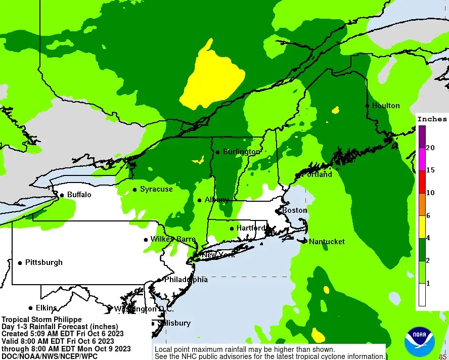
Strong winds and heavy rain to impact New England as Philippe approaches and moves across the region, U.S.
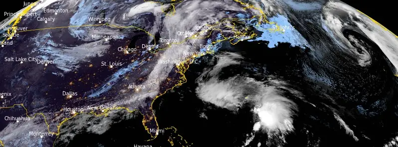
Featured image: Tropical Storm "Philippe" at 08:30 UTC on October 6, 2023. Credit: NOAA/GOES-East, RAMMB/CIRA, The Watchers
Over the next couple of days, the focus of impactful weather in the United States will shift into the northeastern region where a deepening upper-level trough is forecast to interact with the circulation associated with Tropical Storm “Philippe” currently moving northward across the western Atlantic toward Bermuda.
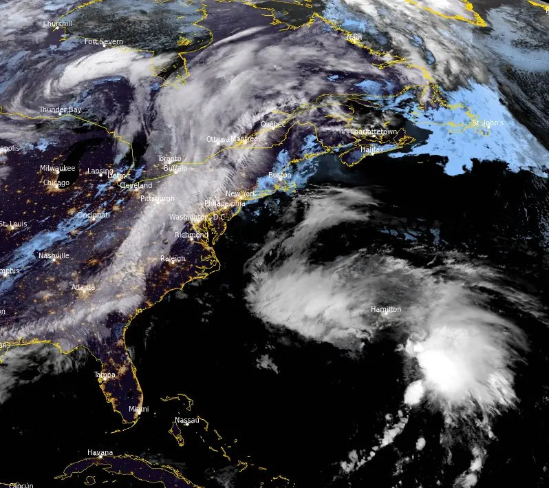
A period of strong winds and heavy rain is expected to impact New England late Saturday, October 7, 2023, to Sunday as the circulation of Philippe approaches and moves across the region.
“Philippe’s structure this morning is consistent of a cyclone in the initial stages of extratropical transition,” NWS forecaster Papin noted at 09:00 UTC today, October 6.
While the low-level circulation center appears better defined than yesterday at this time, most of the deep convection remains displaced well east of the center. There is another cloud band of linear convection to the northwest of the center, but this appears more related to synoptic forcing caused by an upper-level cutoff low triggering non-tropical surface cyclogenesis west of Philippe. The interaction of this low with Philippe will likely dictate how quickly its completion of extratropical transition is.
The storm is caught in the flow between the aforementioned cutoff low to its west, and an amplified mid-level ridge to its east. An additional complication is the non-tropical surface cyclone forming to the west of Philippe that may also interact with it over the next day or so.
The end result of this interaction is that there might be a short-term north-northeastward deviation in Philippe’s motion, but then pivots back north-northwest as the two systems undergo some binary interaction with each other.
While environmental conditions are becoming increasingly hostile for intensification as a tropical cyclone, Philippe’s winds may still increase slightly over the next 24 – 36 hours as it gets some baroclinic enhancement from the aforementioned upper-level trough interaction with the system. This trough interaction is also likely responsible for initiating its extratropical transition, and the latest forecast now shows Philippe completing this process and becoming a post-tropical cyclone in 36 hours.
Given the current structure, this could occur sooner after passing by north of Bermuda. Another even more amplified trough should fully capture this post-tropical cyclone, and weakening is expected after Philippe moves inland over New England and Atlantic Canada on Sunday, October 8.

What’s left of Philippe will be absorbed by a much larger mid-latitude cyclone that is expected to occlude over Quebec.
Based on the forecast for Philippe to become post-tropical on Saturday, and after coordination with National Weather Service offices in New England and the Canadian Hurricane Centre, the current plan is for hazards in New England and Atlantic Canada to be handled via local non-tropical statements and not issue tropical watches or warnings.
At 09:00 UTC on October 6, the center of Tropical Storm “Philippe” was located about 315 km (195 miles) S of Bermuda. The system had maximum sustained winds of 85 km/h (50 mph), minimum central pressure of 1 003 hPa, and was heading NNE at 30 km/h (18 mph).
On the forecast track, the center of Philippe will pass near Bermuda later today, and then reach the coast of Nova Scotia, New Brunswick, or eastern Maine Saturday night into Sunday.
Tropical storm conditions are beginning in Bermuda and are expected to continue today, where a Tropical Storm Warning remains in effect. Heavy rainfall is expected to affect the island into early Friday. This could produce flash flooding.
Philippe is expected to move over portions of Atlantic Canada and New England as a post-tropical cyclone this weekend. Regardless of Philippe’s intensity or structure, interests in those areas should be prepared for the possibility of strong winds and heavy rainfall and monitor statements from their local weather office. The rainfall may produce isolated to scattered instances of urban and flash flooding.
References:
1 Tropical Storm Philippe Discussion Number 52 – NWS National Hurricane Center Miami FL AL172023 – 500 AM AST Fri Oct 06 2023
2 Tropical Storm Philippe Advisory Number 52 – NWS National Hurricane Center Miami FL AL172023 500 AM AST Fri Oct 06 2023
The Watchers team and our contributors bring the latest on extreme weather, earthquakes, volcanic eruptions, space weather, and all things science. We're all about making sense of the natural world and keeping you informed on what’s happening. Got a tip or a question? Hit us up using the form at newstips!
Commenting rules and guidelines
We value the thoughts and opinions of our readers and welcome healthy discussions on our website. In order to maintain a respectful and positive community, we ask that all commenters follow these rules.